Los Naranjos Esquipulas elevation
Los Naranjos Esquipulas (Oaxaca, San Pedro el Alto), Mexico elevation is 1377 meters and Los Naranjos Esquipulas elevation in feet is 4518 ft above sea level [src 1]. Los Naranjos Esquipulas is a populated place (feature code) with elevation that is 63 meters (207 ft) bigger than average city elevation in Mexico.
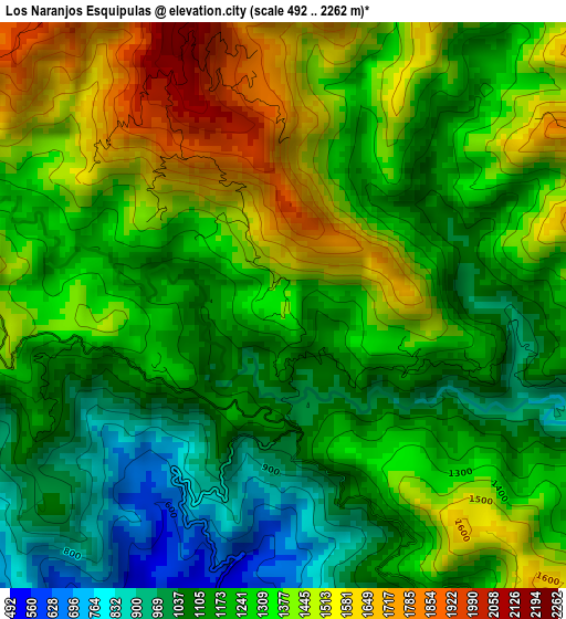
Below is the Elevation map of Los Naranjos Esquipulas, which displays elevation range with different colors. Scale of the first map is from 492 to 2262 m (1614 to 7421 ft) with average elevation of 1275.1 meters (=4183 ft) [note 1]
These maps also provides idea of topography and contour of this city, they are displayed at different zoom levels. More info about maps, scale and edge coordinates you can find below images.
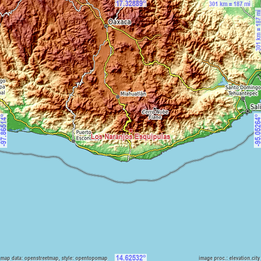
| \ | Map #1 | Topo.Map |
| Scale [m] | 492..2262 m | × |
| Scale [ft] | 1614..7421 ft | × |
| Average | 1275.1 m = 4183 ft | × |
| Width | 9.39 km = 5.8 mi | 300.6 km = 186.8 mi |
| Height | 9.39 km = 5.8 mi | 300.6 km = 186.8 mi |
| ↑Max Latitude | 16.023912° | 17.32889° |
| Latitude at center | 15.98167° | 15.98167° |
| ↓Min Latitude | 15.939419° | 14.62532° |
| ← Min Longitude | -96.502835° | -97.86514° |
| Longitude center | -96.45889° | -96.45889° |
| →Max Longitude | -96.414945° | -95.05264° |
Nearby cities:
Cities around Los Naranjos Esquipulas sort by population:
• San Agustín Loxicha elevation 1836 m
17.3 km,  283°
283°
• Candelaria Loxicha 452 m
7.1 km,  210°
210°
• San José Chacalapa 231 m
16.9 km,  181°
181°
• San Miguel Suchixtepec 2613 m
12.5 km,  355°
355°
• Benito Juárez 339 m
18.2 km,  127°
127°
• Santa Cruz Ozolotepec 1465 m
19.4 km,  59°
59°
• La Erradura 216 m
21.1 km,  141°
141°
• San Marcial Ozolotepec 2360 m
13.2 km,  25°
25°
• El Camalote 329 m
21.4 km,  235°
235°
• San Francisco Loxicha 497 m
18.5 km, 243°
• Pluma Hidalgo 1322 m
7.4 km, 144°
• San Mateo Piñas 1051 m
13.5 km,  81°
81°
Multilingual:
 En español:
Los Naranjos Esquipulas elevación 1377 m.
 En France:
Los Naranjos Esquipulas élévation 1377 m.
 Auf Deutsch:
Los Naranjos Esquipulas höhe über dem Meeresspiegel ist 1377 m.
 На русском:
Los Naranjos Esquipulas высота над уровнем моря 1377 м
Sources and notes:
- [note 1] Map square and city borders are not equal. Map elevation data is calculated only from area inside that square.
- [src 1] Elevation data from geonames database provided with same terms of usage.
- [src 2] The elevation map of Los Naranjos Esquipulas is generated using elevation data from NASA's 3 arcsec (90m) resolution SRTM data.
- [src 3] Base (background) map © OpenStreetMap contributors tiles are generated by Geofabrik and OpenTopoMap.
Copyright & License:
This Los Naranjos Esquipulas Elevation Map is licensed under CC BY-SA. You may reuse any part from this page, if you give a proper credit by linking to this URL:
 More info on terms of use page.