El Arador elevation
El Arador (Oaxaca, San Lorenzo Texmelúcan), Mexico elevation is 1352 meters and El Arador elevation in feet is 4436 ft above sea level [src 1]. El Arador is a populated place (feature code) with elevation that is 38 meters (125 ft) bigger than average city elevation in Mexico.
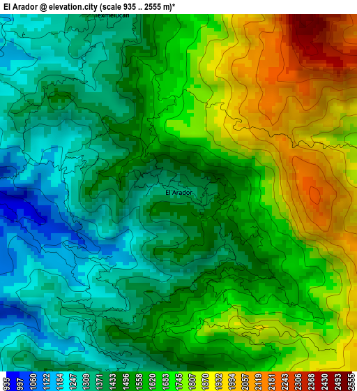
Below is the Elevation map of El Arador, which displays elevation range with different colors. Scale of the first map is from 935 to 2555 m (3068 to 8383 ft) with average elevation of 1567 meters (=5141 ft) [note 1]
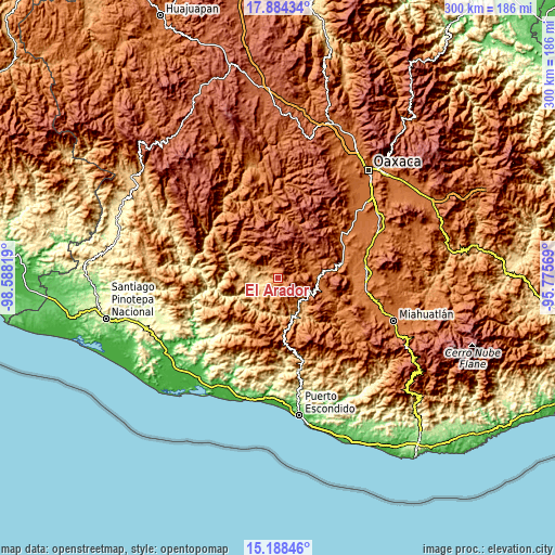
These maps also provides idea of topography and contour of this city, they are displayed at different zoom levels. More info about maps, scale and edge coordinates you can find below images.
| \ | Map #1 | Topo.Map |
| Scale [m] | 935..2555 m | × |
| Scale [ft] | 3068..8383 ft | × |
| Average | 1567 m = 5141 ft | × |
| Width | 9.37 km = 5.8 mi | 299.8 km = 186.3 mi |
| Height | 9.37 km = 5.8 mi | 299.8 km = 186.3 mi |
| ↑Max Latitude | 16.583232° | 17.88434° |
| Latitude at center | 16.54111° | 16.54111° |
| ↓Min Latitude | 16.498979° | 15.18846° |
| ← Min Longitude | -97.225885° | -98.58819° |
| Longitude center | -97.18194° | -97.18194° |
| →Max Longitude | -97.137995° | -95.77569° |
Nearby cities:
Cities around El Arador sort by population:
• Teojomulco elevation 1266 m
7.1 km,  320°
320°
• Villa Sola de Vega 1443 m
21.9 km,  96°
96°
• San Pedro Juchaltengo 854 m
23.9 km,  155°
155°
• Santa María Zaniza 1311 m
20.9 km,  307°
307°
• Cieneguilla 1620 m
28.2 km,  210°
210°
• San Vicente Lachixío 2203 m
25.2 km,  43°
43°
• Santa María Lachixío 2251 m
27 km, 40°
• San Cristóbal Honduras 1090 m
28.3 km,  147°
147°
• San Francisco Sola 1419 m
22.2 km, 97°
• Santiago Textitlán 1734 m
18.7 km,  334°
334°
• Santa María Sola 1450 m
18.2 km,  81°
81°
• Texmelucan 1407 m
5.2 km,  339°
339°
Multilingual:
 En español:
El Arador elevación 1352 m.
 En France:
El Arador élévation 1352 m.
 Auf Deutsch:
El Arador höhe über dem Meeresspiegel ist 1352 m.

Sources and notes:
- [note 1] Map square and city borders are not equal. Map elevation data is calculated only from area inside that square.
- [src 1] Elevation data from geonames database provided with same terms of usage.
- [src 2] The elevation map of El Arador is generated using elevation data from NASA's 3 arcsec (90m) resolution SRTM data.
- [src 3] Base (background) map © OpenStreetMap contributors tiles are generated by Geofabrik and OpenTopoMap.
Copyright & License:
This El Arador Elevation Map is licensed under CC BY-SA. You may reuse any part from this page, if you give a proper credit by linking to this URL:
 More info on terms of use page.