San Pedro Juchaltengo elevation
San Pedro Juchaltengo (Oaxaca, San Pedro Juchatengo), Mexico elevation is 854 meters and San Pedro Juchaltengo elevation in feet is 2802 ft above sea level [src 1]. San Pedro Juchaltengo is a populated place (feature code) with elevation that is 460 meters (1509 ft) smaller than average city elevation in Mexico.
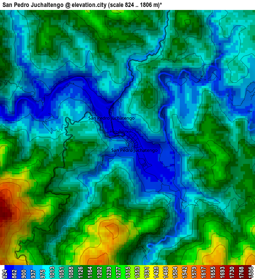
Below is the Elevation map of San Pedro Juchaltengo, which displays elevation range with different colors. Scale of the first map is from 824 to 1806 m (2703 to 5925 ft) with average elevation of 1085.5 meters (=3561 ft) [note 1]
These maps also provides idea of topography and contour of this city, they are displayed at different zoom levels. More info about maps, scale and edge coordinates you can find below images.
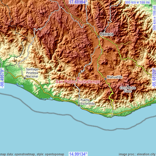
| \ | Map #1 | Topo.Map |
| Scale [m] | 824..1806 m | × |
| Scale [ft] | 2703..5925 ft | × |
| Average | 1085.5 m = 3561 ft | × |
| Width | 9.38 km = 5.8 mi | 300.1 km = 186.5 mi |
| Height | 9.38 km = 5.8 mi | 300.1 km = 186.5 mi |
| ↑Max Latitude | 16.387465° | 17.68994° |
| Latitude at center | 16.3453° | 16.3453° |
| ↓Min Latitude | 16.303126° | 14.99134° |
| ← Min Longitude | -97.133485° | -98.49579° |
| Longitude center | -97.08954° | -97.08954° |
| →Max Longitude | -97.045595° | -95.68329° |
Nearby cities:
Cities around San Pedro Juchaltengo sort by population:
• Santa Catarina Juquila elevation 1441 m
24.6 km,  241°
241°
• Santiago Yaitepec 1783 m
23.3 km, 235°
• San Juan Quiahue 1939 m
24.8 km,  258°
258°
• Villa Sola de Vega 1443 m
22.6 km,  31°
31°
• Santa Lucía Teotepec 1195 m
25.9 km,  209°
209°
• El Arador 1352 m
23.9 km,  335°
335°
• Santa María Temaxcaltepec 1324 m
23.1 km, 209°
• Cieneguilla 1620 m
24.5 km, 264°
• San Juan Lachao 597 m
21.1 km,  190°
190°
• San Cristóbal Honduras 1090 m
5.6 km,  113°
113°
• San Francisco Sola 1419 m
22.6 km, 32°
• Santa María Sola 1450 m
25.9 km,  18°
18°
Multilingual:
 En español:
San Pedro Juchaltengo elevación 854 m.
 En France:
San Pedro Juchaltengo élévation 854 m.
 Auf Deutsch:
San Pedro Juchaltengo höhe über dem Meeresspiegel ist 854 m.
 На русском:
San Pedro Juchaltengo высота над уровнем моря 854 м
Sources and notes:
- [note 1] Map square and city borders are not equal. Map elevation data is calculated only from area inside that square.
- [src 1] Elevation data from geonames database provided with same terms of usage.
- [src 2] The elevation map of San Pedro Juchaltengo is generated using elevation data from NASA's 3 arcsec (90m) resolution SRTM data.
- [src 3] Base (background) map © OpenStreetMap contributors tiles are generated by Geofabrik and OpenTopoMap.
Copyright & License:
This San Pedro Juchaltengo Elevation Map is licensed under CC BY-SA. You may reuse any part from this page, if you give a proper credit by linking to this URL:
 More info on terms of use page.