Miraflores elevation
Miraflores (State of Mexico, Chalco), Mexico elevation is 2326 meters and Miraflores elevation in feet is 7631 ft above sea level [src 1]. Miraflores is a populated place (feature code) with elevation that is 1012 meters (3320 ft) bigger than average city elevation in Mexico.
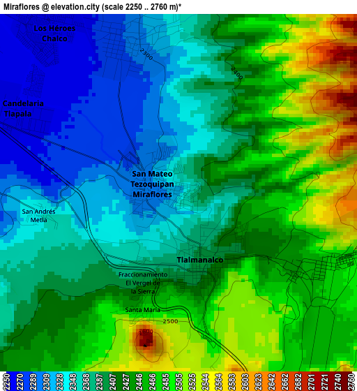
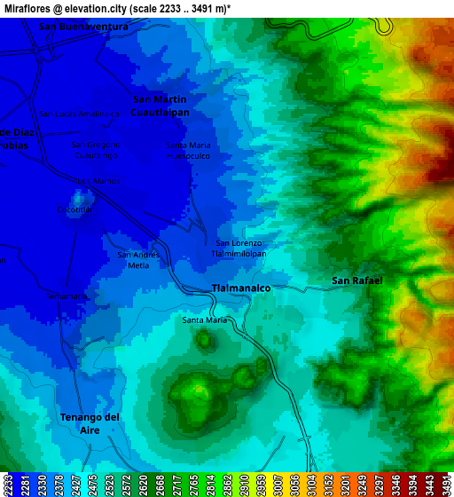
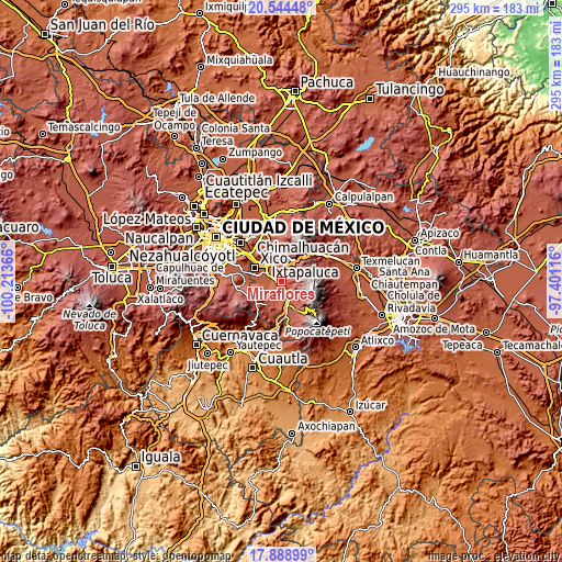
Below is the Elevation map of Miraflores, which displays elevation range with different colors. Scale of the first map is from 2250 to 2760 m (7382 to 9055 ft) with average elevation of 2410.4 meters (=7908 ft) [note 1]
These maps also provides idea of topography and contour of this city, they are displayed at different zoom levels. More info about maps, scale and edge coordinates you can find below images.
| \ | Map #1 | Map #2 | Topo.Map |
| Scale [m] | 2250..2760 m | 2233..3491 m | × |
| Scale [ft] | 7382..9055 ft | 7326..11453 ft | × |
| Average | 2410.4 m = 7908 ft | 2520.1 m = 8268 ft | × |
| Width | 9.23 km = 5.7 mi | 18.46 km = 11.5 mi | 295.3 km = 183.5 mi |
| Height | 9.23 km = 5.7 mi | 18.46 km = 11.5 mi | 295.3 km = 183.5 mi |
| ↑Max Latitude | 19.26359° | 19.30507° | 20.54448° |
| Latitude at center | 19.2221° | 19.2221° | 19.2221° |
| ↓Min Latitude | 19.180599° | 19.139088° | 17.88899° |
| ← Min Longitude | -98.851355° | -98.895301° | -100.21366° |
| Longitude center | -98.80741° | -98.80741° | -98.80741° |
| →Max Longitude | -98.763465° | -98.719519° | -97.40116° |
Nearby cities:
Cities around Miraflores sort by population:
• San Martín Cuautlalpan elevation 2279 m
6.5 km,  337°
337°
• San Rafael 2552 m
5.5 km,  104°
104°
• Tlalmanalco 2404 m
2 km,  160°
160°
• San Gregorio Cuautzingo 2252 m
6.7 km,  308°
308°
• Santa María Huexoculco 2293 m
4.2 km, 341°
• Cocotitlán 2313 m
6.3 km,  281°
281°
• Temamatla 2278 m
6.8 km,  251°
251°
• La Candelaria Tlapala 2260 m
4.7 km,  295°
295°
• San Lorenzo Tlalmimilolpan 2375 m
0.3 km,  110°
110°
• Santo Tomás Atzingo 2491 m
6.3 km,  151°
151°
• San Andrés Metla 2345 m
3.6 km,  260°
260°
• El Cabi 2362 m
6 km,  233°
233°
Multilingual:
 En español:
Miraflores elevación 2326 m.
 En France:
Miraflores élévation 2326 m.
 Auf Deutsch:
Miraflores höhe über dem Meeresspiegel ist 2326 m.

Sources and notes:
- [note 1] Map square and city borders are not equal. Map elevation data is calculated only from area inside that square.
- [src 1] Elevation data from geonames database provided with same terms of usage.
- [src 2] The elevation map of Miraflores is generated using elevation data from NASA's 3 arcsec (90m) resolution SRTM data.
- [src 3] Base (background) map © OpenStreetMap contributors tiles are generated by Geofabrik and OpenTopoMap.
Copyright & License:
This Miraflores Elevation Map is licensed under CC BY-SA. You may reuse any part from this page, if you give a proper credit by linking to this URL:
 More info on terms of use page.