San Rafael elevation
San Rafael (State of Mexico, Tlalmanalco), Mexico elevation is 2552 meters and San Rafael elevation in feet is 8373 ft above sea level [src 1]. San Rafael is a populated place (feature code) with elevation that is 1238 meters (4062 ft) bigger than average city elevation in Mexico.
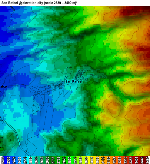
Below is the Elevation map of San Rafael, which displays elevation range with different colors. Scale of the first map is from 2339 to 3490 m (7674 to 11450 ft) with average elevation of 2739.5 meters (=8988 ft) [note 1]
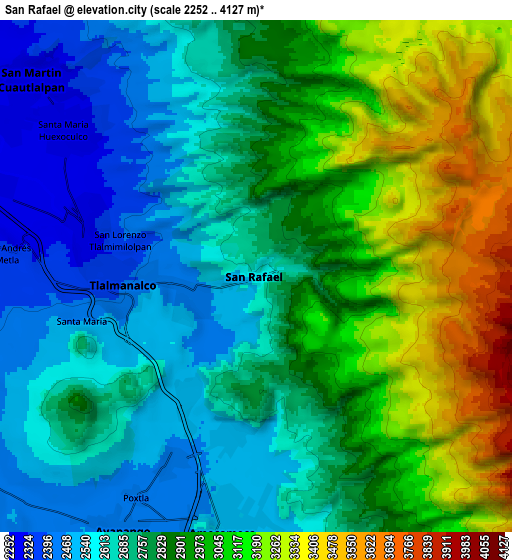
These maps also provides idea of topography and contour of this city, they are displayed at different zoom levels. More info about maps, scale and edge coordinates you can find below images.
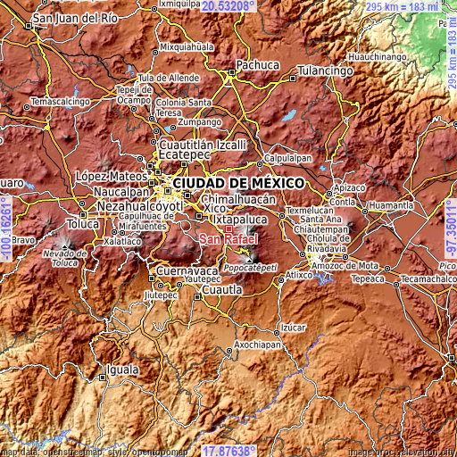
| \ | Map #1 | Map #2 | Topo.Map |
| Scale [m] | 2339..3490 m | 2252..4127 m | × |
| Scale [ft] | 7674..11450 ft | 7388..13540 ft | × |
| Average | 2739.5 m = 8988 ft | 2841.2 m = 9322 ft | × |
| Width | 9.23 km = 5.7 mi | 18.46 km = 11.5 mi | 295.3 km = 183.5 mi |
| Height | 9.23 km = 5.7 mi | 18.46 km = 11.5 mi | 295.3 km = 183.5 mi |
| ↑Max Latitude | 19.251083° | 19.292566° | 20.53208° |
| Latitude at center | 19.20959° | 19.20959° | 19.20959° |
| ↓Min Latitude | 19.168086° | 19.126572° | 17.87638° |
| ← Min Longitude | -98.800305° | -98.844251° | -100.16261° |
| Longitude center | -98.75636° | -98.75636° | -98.75636° |
| →Max Longitude | -98.712415° | -98.668469° | -97.35011° |
Nearby cities:
Cities around San Rafael sort by population:
• Amecameca elevation 2480 m
9.6 km,  186°
186°
• Tlalmanalco 2404 m
4.7 km,  264°
264°
• Santa María Huexoculco 2293 m
8.6 km,  308°
308°
• Miraflores 2326 m
5.5 km,  284°
284°
• San Lorenzo Tlalmimilolpan 2375 m
5.3 km, 284°
• Santa Isabel Chalma 2483 m
5.9 km, 189°
• Santo Tomás Atzingo 2491 m
4.7 km,  209°
209°
• Zentlalpan 2460 m
7.3 km,  204°
204°
• San Antonio Tlaltecahuacán 2478 m
5.9 km, 192°
• San Andrés Metla 2345 m
9 km, 275°
• Santiago Cuautenco 2520 m
6.9 km,  171°
171°
• La Colonia 2457 m
7.9 km, 203°
Multilingual:
 En español:
San Rafael elevación 2552 m.
 En France:
San Rafael élévation 2552 m.
 Auf Deutsch:
San Rafael höhe über dem Meeresspiegel ist 2552 m.

Sources and notes:
- [note 1] Map square and city borders are not equal. Map elevation data is calculated only from area inside that square.
- [src 1] Elevation data from geonames database provided with same terms of usage.
- [src 2] The elevation map of San Rafael is generated using elevation data from NASA's 3 arcsec (90m) resolution SRTM data.
- [src 3] Base (background) map © OpenStreetMap contributors tiles are generated by Geofabrik and OpenTopoMap.
Copyright & License:
This San Rafael Elevation Map is licensed under CC BY-SA. You may reuse any part from this page, if you give a proper credit by linking to this URL:
 More info on terms of use page.