Amecameca elevation
Amecameca (State of Mexico), Mexico elevation is 2480 meters and Amecameca elevation in feet is 8136 ft above sea level [src 1]. Amecameca is a populated place (feature code) with elevation that is 1166 meters (3825 ft) bigger than average city elevation in Mexico.
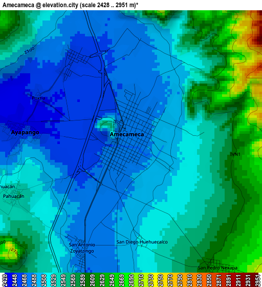
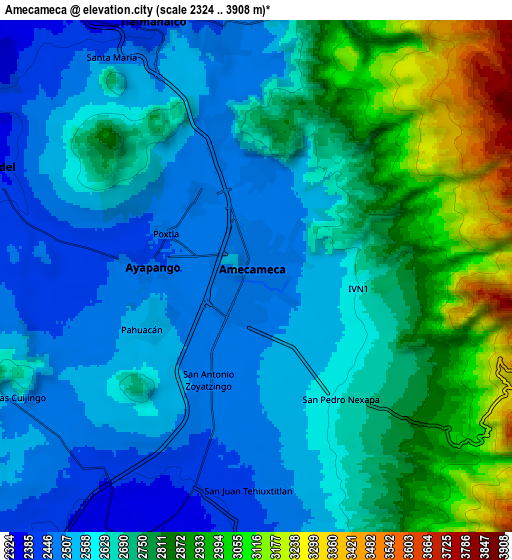
Below is the Elevation map of Amecameca, which displays elevation range with different colors. Scale of the first map is from 2428 to 2951 m (7966 to 9682 ft) with average elevation of 2530.6 meters (=8302 ft) [note 1]
These maps also provides idea of topography and contour of this city, they are displayed at different zoom levels. More info about maps, scale and edge coordinates you can find below images.
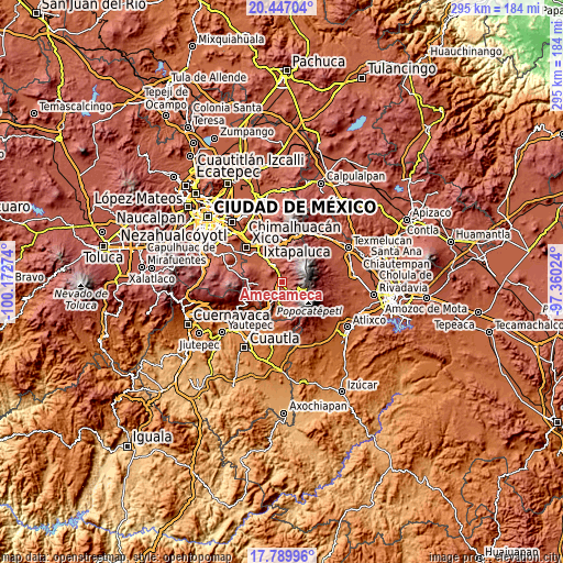
| \ | Map #1 | Map #2 | Topo.Map |
| Scale [m] | 2428..2951 m | 2324..3908 m | × |
| Scale [ft] | 7966..9682 ft | 7625..12822 ft | × |
| Average | 2530.6 m = 8302 ft | 2688.5 m = 8821 ft | × |
| Width | 9.23 km = 5.7 mi | 18.47 km = 11.5 mi | 295.4 km = 183.6 mi |
| Height | 9.23 km = 5.7 mi | 18.47 km = 11.5 mi | 295.5 km = 183.6 mi |
| ↑Max Latitude | 19.165355° | 19.206859° | 20.44704° |
| Latitude at center | 19.12384° | 19.12384° | 19.12384° |
| ↓Min Latitude | 19.082315° | 19.040779° | 17.78996° |
| ← Min Longitude | -98.810435° | -98.854381° | -100.17274° |
| Longitude center | -98.76649° | -98.76649° | -98.76649° |
| →Max Longitude | -98.722545° | -98.678599° | -97.36024° |
Nearby cities:
Cities around Amecameca sort by population:
• San Juan Tehuixtitlán elevation 2446 m
7.7 km,  180°
180°
• Ayapango 2447 m
3.5 km,  275°
275°
• San Pedro Nexapa 2629 m
5.4 km,  145°
145°
• Zoyatzingo 2479 m
4.1 km,  205°
205°
• Santa Isabel Chalma 2483 m
3.7 km,  1°
1°
• Santo Tomás Atzingo 2491 m
5.6 km,  346°
346°
• San Diego Huehuecalco 2513 m
3.5 km,  174°
174°
• Zentlalpan 2460 m
3.5 km,  326°
326°
• San Antonio Tlaltecahuacán 2478 m
3.8 km,  356°
356°
• Santiago Cuautenco 2520 m
3.4 km,  37°
37°
• Popo Park 2433 m
6.7 km,  193°
193°
• La Colonia 2457 m
3.1 km,  317°
317°
Multilingual:
 En español:
Amecameca elevación 2480 m.
 En France:
Amecameca élévation 2480 m.
 Auf Deutsch:
Amecameca höhe über dem Meeresspiegel ist 2480 m.

Sources and notes:
- [note 1] Map square and city borders are not equal. Map elevation data is calculated only from area inside that square.
- [src 1] Elevation data from geonames database provided with same terms of usage.
- [src 2] The elevation map of Amecameca is generated using elevation data from NASA's 3 arcsec (90m) resolution SRTM data.
- [src 3] Base (background) map © OpenStreetMap contributors tiles are generated by Geofabrik and OpenTopoMap.
Copyright & License:
This Amecameca Elevation Map is licensed under CC BY-SA. You may reuse any part from this page, if you give a proper credit by linking to this URL:
 More info on terms of use page.