San Pedro Nexapa elevation
San Pedro Nexapa (State of Mexico, Amecameca), Mexico elevation is 2629 meters and San Pedro Nexapa elevation in feet is 8625 ft above sea level [src 1]. San Pedro Nexapa is a populated place (feature code) with elevation that is 1315 meters (4314 ft) bigger than average city elevation in Mexico.
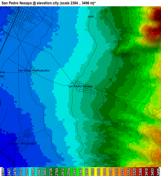
Below is the Elevation map of San Pedro Nexapa, which displays elevation range with different colors. Scale of the first map is from 2384 to 3496 m (7822 to 11470 ft) with average elevation of 2660 meters (=8727 ft) [note 1]
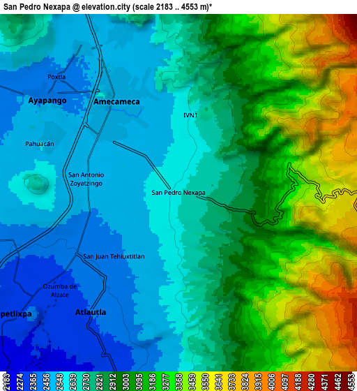
These maps also provides idea of topography and contour of this city, they are displayed at different zoom levels. More info about maps, scale and edge coordinates you can find below images.
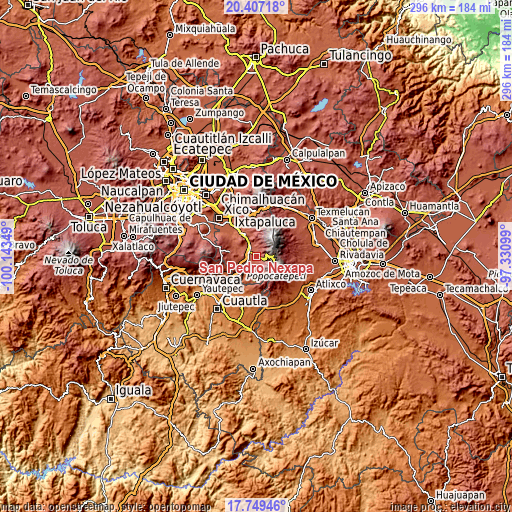
| \ | Map #1 | Map #2 | Topo.Map |
| Scale [m] | 2384..3496 m | 2183..4553 m | × |
| Scale [ft] | 7822..11470 ft | 7162..14938 ft | × |
| Average | 2660 m = 8727 ft | 2856 m = 9370 ft | × |
| Width | 9.24 km = 5.7 mi | 18.47 km = 11.5 mi | 295.5 km = 183.6 mi |
| Height | 9.24 km = 5.7 mi | 18.47 km = 11.5 mi | 295.5 km = 183.6 mi |
| ↑Max Latitude | 19.125175° | 19.166689° | 20.40718° |
| Latitude at center | 19.08365° | 19.08365° | 19.08365° |
| ↓Min Latitude | 19.042115° | 19.000569° | 17.74946° |
| ← Min Longitude | -98.781185° | -98.825131° | -100.14349° |
| Longitude center | -98.73724° | -98.73724° | -98.73724° |
| →Max Longitude | -98.693295° | -98.649349° | -97.33099° |
Nearby cities:
Cities around San Pedro Nexapa sort by population:
• Amecameca elevation 2480 m
5.4 km,  325°
325°
• Ozumba de Alzate 2342 m
8 km,  229°
229°
• Atlautla 2365 m
8.1 km,  212°
212°
• San Juan Tehuixtitlán 2446 m
4.5 km,  223°
223°
• Ayapango 2447 m
8.2 km,  306°
306°
• San Mateo Tecalco 2374 m
7 km,  241°
241°
• Zoyatzingo 2479 m
4.9 km,  278°
278°
• Santa Isabel Chalma 2483 m
8.7 km,  340°
340°
• San Diego Huehuecalco 2513 m
2.9 km,  290°
290°
• Santiago Cuautenco 2520 m
7.2 km,  351°
351°
• Popo Park 2433 m
5 km,  245°
245°
• La Colonia 2457 m
8.5 km,  322°
322°
Multilingual:
 En español:
San Pedro Nexapa elevación 2629 m.
 En France:
San Pedro Nexapa élévation 2629 m.
 Auf Deutsch:
San Pedro Nexapa höhe über dem Meeresspiegel ist 2629 m.

Sources and notes:
- [note 1] Map square and city borders are not equal. Map elevation data is calculated only from area inside that square.
- [src 1] Elevation data from geonames database provided with same terms of usage.
- [src 2] The elevation map of San Pedro Nexapa is generated using elevation data from NASA's 3 arcsec (90m) resolution SRTM data.
- [src 3] Base (background) map © OpenStreetMap contributors tiles are generated by Geofabrik and OpenTopoMap.
Copyright & License:
This San Pedro Nexapa Elevation Map is licensed under CC BY-SA. You may reuse any part from this page, if you give a proper credit by linking to this URL:
 More info on terms of use page.