Aljojuca elevation
Aljojuca (Puebla), Mexico elevation is 2485 meters and Aljojuca elevation in feet is 8153 ft above sea level [src 1]. Aljojuca is a populated place (feature code) with elevation that is 1171 meters (3842 ft) bigger than average city elevation in Mexico.
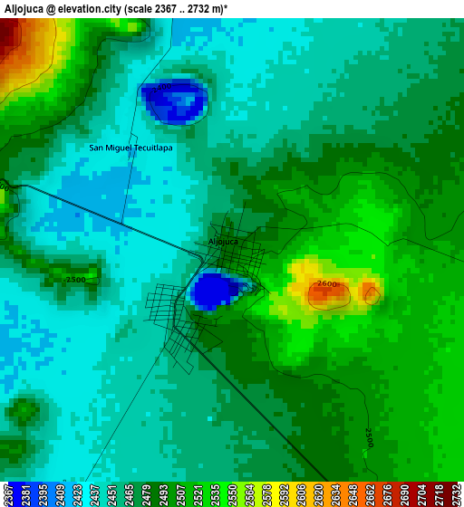
Below is the Elevation map of Aljojuca, which displays elevation range with different colors. Scale of the first map is from 2367 to 2732 m (7766 to 8963 ft) with average elevation of 2475.1 meters (=8120 ft) [note 1]
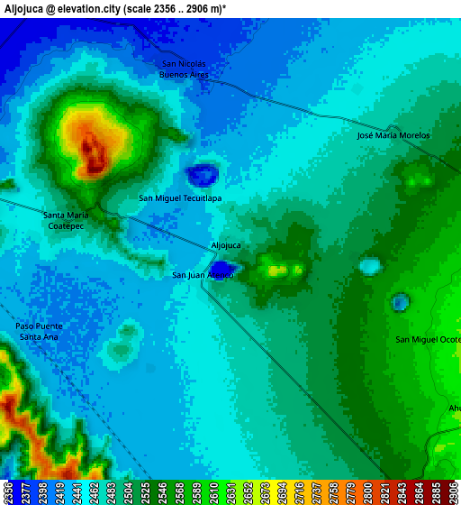
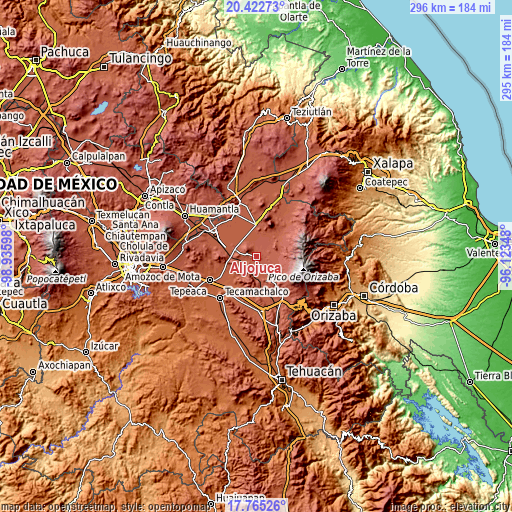
These maps also provides idea of topography and contour of this city, they are displayed at different zoom levels. More info about maps, scale and edge coordinates you can find below images.
| \ | Map #1 | Map #2 | Topo.Map |
| Scale [m] | 2367..2732 m | 2356..2906 m | × |
| Scale [ft] | 7766..8963 ft | 7730..9534 ft | × |
| Average | 2475.1 m = 8120 ft | 2485.6 m = 8155 ft | × |
| Width | 9.23 km = 5.7 mi | 18.47 km = 11.5 mi | 295.5 km = 183.6 mi |
| Height | 9.23 km = 5.7 mi | 18.47 km = 11.5 mi | 295.5 km = 183.6 mi |
| ↑Max Latitude | 19.140851° | 19.182362° | 20.42273° |
| Latitude at center | 19.09933° | 19.09933° | 19.09933° |
| ↓Min Latitude | 19.057799° | 19.016257° | 17.76526° |
| ← Min Longitude | -97.573675° | -97.617621° | -98.93598° |
| Longitude center | -97.52973° | -97.52973° | -97.52973° |
| →Max Longitude | -97.485785° | -97.441839° | -96.12348° |
Nearby cities:
Cities around Aljojuca sort by population:
• San Salvador El Seco elevation 2437 m
12.4 km,  287°
287°
• Tlachichuca 2616 m
11.7 km,  81°
81°
• Santa Maria Coatepec 2504 m
6.7 km,  279°
279°
• San Nicolas Buenos Aires 2388 m
7.6 km,  342°
342°
• San Francisco Independencia (Santa María Aserradero) 2666 m
11 km,  107°
107°
• Santa Catarina Villanueva 2359 m
14.3 km,  218°
218°
• San Juan Atenco 2453 m
1.8 km, 219°
• San Miguel Ocotenco 2609 m
8.9 km, 114°
• San Miguel Tecuitlapa 2430 m
3 km,  323°
323°
• Ahuatepec de Camino 2664 m
11.9 km,  123°
123°
• José María Morelos 2483 m
8 km,  54°
54°
• Guadalupe Victoria 2443 m
8 km,  274°
274°
Multilingual:
 En español:
Aljojuca elevación 2485 m.
 En France:
Aljojuca élévation 2485 m.
 Auf Deutsch:
Aljojuca höhe über dem Meeresspiegel ist 2485 m.

Sources and notes:
- [note 1] Map square and city borders are not equal. Map elevation data is calculated only from area inside that square.
- [src 1] Elevation data from geonames database provided with same terms of usage.
- [src 2] The elevation map of Aljojuca is generated using elevation data from NASA's 3 arcsec (90m) resolution SRTM data.
- [src 3] Base (background) map © OpenStreetMap contributors tiles are generated by Geofabrik and OpenTopoMap.
Copyright & License:
This Aljojuca Elevation Map is licensed under CC BY-SA. You may reuse any part from this page, if you give a proper credit by linking to this URL:
 More info on terms of use page.