Ahuatepec de Camino elevation
Ahuatepec de Camino (Puebla, Chalchicomula de Sesma), Mexico elevation is 2664 meters and Ahuatepec de Camino elevation in feet is 8740 ft above sea level [src 1]. Ahuatepec de Camino is a populated place (feature code) with elevation that is 1350 meters (4429 ft) bigger than average city elevation in Mexico.
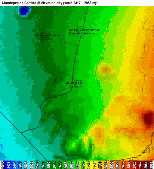
Below is the Elevation map of Ahuatepec de Camino, which displays elevation range with different colors. Scale of the first map is from 2417 to 2986 m (7930 to 9797 ft) with average elevation of 2661.9 meters (=8733 ft) [note 1]
These maps also provides idea of topography and contour of this city, they are displayed at different zoom levels. More info about maps, scale and edge coordinates you can find below images.
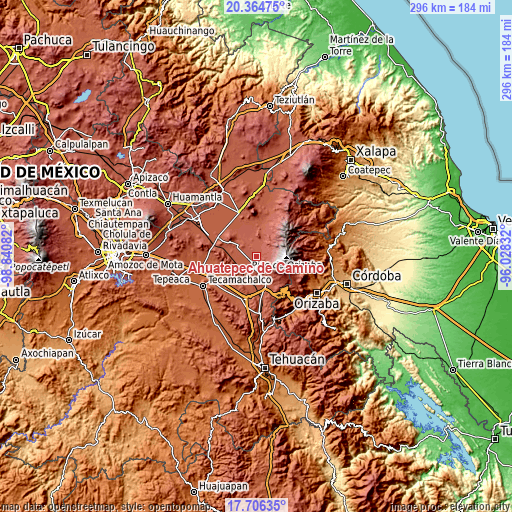
| \ | Map #1 | Topo.Map |
| Scale [m] | 2417..2986 m | × |
| Scale [ft] | 7930..9797 ft | × |
| Average | 2661.9 m = 8733 ft | × |
| Width | 9.24 km = 5.7 mi | 295.6 km = 183.7 mi |
| Height | 9.24 km = 5.7 mi | 295.6 km = 183.7 mi |
| ↑Max Latitude | 19.082406° | 20.36475° |
| Latitude at center | 19.04087° | 19.04087° |
| ↓Min Latitude | 18.999324° | 17.70635° |
| ← Min Longitude | -97.478515° | -98.84082° |
| Longitude center | -97.43457° | -97.43457° |
| →Max Longitude | -97.390625° | -96.02832° |
Nearby cities:
Cities around Ahuatepec de Camino sort by population:
• Ciudad Serdán elevation 2548 m
5.9 km,  192°
192°
• Tlachichuca 2616 m
8.4 km,  11°
11°
• San Francisco Cuautlancingo 2736 m
5.3 km,  157°
157°
• San Francisco Independencia (Santa María Aserradero) 2666 m
3.1 km, 8°
• San Miguel Ocotenco 2609 m
3.4 km,  326°
326°
• José María Morelos 2483 m
11.7 km,  342°
342°
• Santa María Techachalco 2536 m
10.4 km,  201°
201°
• Lázaro Cárdenas 2581 m
11.9 km,  17°
17°
• El Veladero 2485 m
9.9 km,  210°
210°
• San Miguel Zoapan 3003 m
9.8 km,  60°
60°
• Manuel Edgardo Ávalos (San Isidro) 2811 m
5.4 km, 56°
• San Martín Ojo de Agua 2845 m
5.5 km,  125°
125°
Multilingual:
 En español:
Ahuatepec de Camino elevación 2664 m.
 En France:
Ahuatepec de Camino élévation 2664 m.
 Auf Deutsch:
Ahuatepec de Camino höhe über dem Meeresspiegel ist 2664 m.
 На русском:
Ahuatepec de Camino высота над уровнем моря 2664 м
Sources and notes:
- [note 1] Map square and city borders are not equal. Map elevation data is calculated only from area inside that square.
- [src 1] Elevation data from geonames database provided with same terms of usage.
- [src 2] The elevation map of Ahuatepec de Camino is generated using elevation data from NASA's 3 arcsec (90m) resolution SRTM data.
- [src 3] Base (background) map © OpenStreetMap contributors tiles are generated by Geofabrik and OpenTopoMap.
Copyright & License:
This Ahuatepec de Camino Elevation Map is licensed under CC BY-SA. You may reuse any part from this page, if you give a proper credit by linking to this URL:
 More info on terms of use page.