Tlachichuca elevation
Tlachichuca (Puebla), Mexico elevation is 2616 meters and Tlachichuca elevation in feet is 8583 ft above sea level [src 1]. Tlachichuca is a populated place (feature code) with elevation that is 1302 meters (4272 ft) bigger than average city elevation in Mexico.
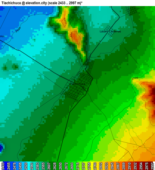
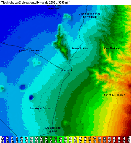
Below is the Elevation map of Tlachichuca, which displays elevation range with different colors. Scale of the first map is from 2433 to 2997 m (7982 to 9833 ft) with average elevation of 2627.9 meters (=8622 ft) [note 1]
These maps also provides idea of topography and contour of this city, they are displayed at different zoom levels. More info about maps, scale and edge coordinates you can find below images.
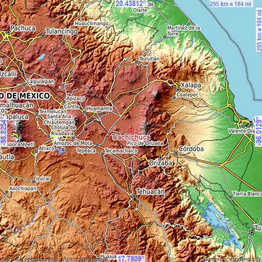
| \ | Map #1 | Map #2 | Topo.Map |
| Scale [m] | 2433..2997 m | 2398..3380 m | × |
| Scale [ft] | 7982..9833 ft | 7867..11089 ft | × |
| Average | 2627.9 m = 8622 ft | 2664.8 m = 8743 ft | × |
| Width | 9.23 km = 5.7 mi | 18.47 km = 11.5 mi | 295.5 km = 183.6 mi |
| Height | 9.23 km = 5.7 mi | 18.47 km = 11.5 mi | 295.5 km = 183.6 mi |
| ↑Max Latitude | 19.156367° | 19.197874° | 20.43812° |
| Latitude at center | 19.11485° | 19.11485° | 19.11485° |
| ↓Min Latitude | 19.073322° | 19.031784° | 17.7809° |
| ← Min Longitude | -97.463095° | -97.507041° | -98.8254° |
| Longitude center | -97.41915° | -97.41915° | -97.41915° |
| →Max Longitude | -97.375205° | -97.331259° | -96.0129° |
Nearby cities:
Cities around Tlachichuca sort by population:
• San Francisco Independencia (Santa María Aserradero) elevation 2666 m
5.2 km,  192°
192°
• Santa Cecilia Tepetitlán 2432 m
8.8 km,  349°
349°
• San Miguel Ocotenco 2609 m
6.4 km,  213°
213°
• Guadalupe Libertad 2518 m
8.8 km,  22°
22°
• Ahuatepec de Camino 2664 m
8.4 km, 191°
• José María Morelos 2483 m
5.9 km,  299°
299°
• Lázaro Cárdenas 2581 m
3.7 km,  31°
31°
• Paso Nacional 2755 m
7.2 km,  63°
63°
• San Miguel Zoapan 3003 m
7.7 km,  116°
116°
• Santa Inés Varela la Luz 2618 m
5.5 km,  35°
35°
• Manuel Edgardo Ávalos (San Isidro) 2811 m
6 km,  151°
151°
• Emancipación Quetzalapa 2551 m
7.1 km, 23°
Multilingual:
 En español:
Tlachichuca elevación 2616 m.
 En France:
Tlachichuca élévation 2616 m.
 Auf Deutsch:
Tlachichuca höhe über dem Meeresspiegel ist 2616 m.

Sources and notes:
- [note 1] Map square and city borders are not equal. Map elevation data is calculated only from area inside that square.
- [src 1] Elevation data from geonames database provided with same terms of usage.
- [src 2] The elevation map of Tlachichuca is generated using elevation data from NASA's 3 arcsec (90m) resolution SRTM data.
- [src 3] Base (background) map © OpenStreetMap contributors tiles are generated by Geofabrik and OpenTopoMap.
Copyright & License:
This Tlachichuca Elevation Map is licensed under CC BY-SA. You may reuse any part from this page, if you give a proper credit by linking to this URL:
 More info on terms of use page.