Ayotla elevation
Ayotla (Puebla, Xochiltepec), Mexico elevation is 1383 meters and Ayotla elevation in feet is 4537 ft above sea level [src 1]. Ayotla is a populated place (feature code) with elevation that is 69 meters (226 ft) bigger than average city elevation in Mexico.
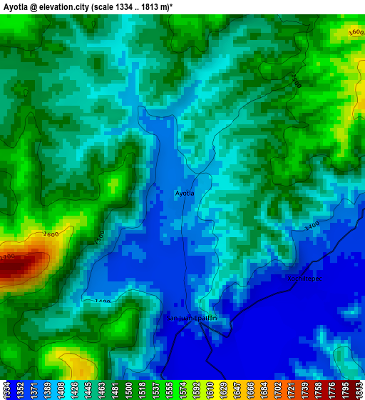
Below is the Elevation map of Ayotla, which displays elevation range with different colors. Scale of the first map is from 1334 to 1813 m (4377 to 5948 ft) with average elevation of 1451.9 meters (=4763 ft) [note 1]
These maps also provides idea of topography and contour of this city, they are displayed at different zoom levels. More info about maps, scale and edge coordinates you can find below images.
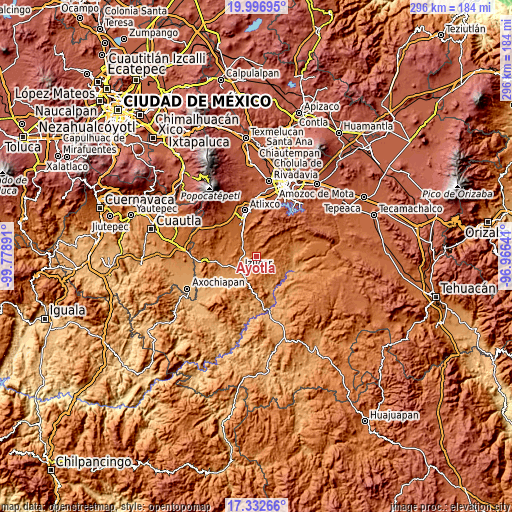
| \ | Map #1 | Topo.Map |
| Scale [m] | 1334..1813 m | × |
| Scale [ft] | 4377..5948 ft | × |
| Average | 1451.9 m = 4763 ft | × |
| Width | 9.26 km = 5.8 mi | 296.2 km = 184 mi |
| Height | 9.26 km = 5.8 mi | 296.3 km = 184.1 mi |
| ↑Max Latitude | 18.711668° | 19.99695° |
| Latitude at center | 18.67004° | 18.67004° |
| ↓Min Latitude | 18.628402° | 17.33266° |
| ← Min Longitude | -98.416605° | -99.77891° |
| Longitude center | -98.37266° | -98.37266° |
| →Max Longitude | -98.328715° | -96.96641° |
Nearby cities:
Cities around Ayotla sort by population:
• Izúcar de Matamoros elevation 1292 m
12.1 km,  230°
230°
• Tepeojuma 1494 m
9.9 km,  308°
308°
• La Galarza 1396 m
8.7 km,  268°
268°
• San Juan Raboso 1272 m
13 km,  212°
212°
• Teopantlán 1427 m
12.4 km,  67°
67°
• Tezonteopan de Bonilla 1548 m
15.2 km,  304°
304°
• San Juan Epatlán 1353 m
3 km,  179°
179°
• Xochiltepec 1346 m
3.6 km,  125°
125°
• San Juan Huiluco 1614 m
15.5 km,  328°
328°
• Santa Ana Necoxtla 1326 m
6.4 km,  189°
189°
• Tejaluca 1367 m
13.4 km,  106°
106°
• Totoltepec 1359 m
3.3 km, 125°
Multilingual:
 En español:
Ayotla elevación 1383 m.
 En France:
Ayotla élévation 1383 m.


Sources and notes:
- [note 1] Map square and city borders are not equal. Map elevation data is calculated only from area inside that square.
- [src 1] Elevation data from geonames database provided with same terms of usage.
- [src 2] The elevation map of Ayotla is generated using elevation data from NASA's 3 arcsec (90m) resolution SRTM data.
- [src 3] Base (background) map © OpenStreetMap contributors tiles are generated by Geofabrik and OpenTopoMap.
Copyright & License:
This Ayotla Elevation Map is licensed under CC BY-SA. You may reuse any part from this page, if you give a proper credit by linking to this URL:
 More info on terms of use page.