Tepeojuma elevation
Tepeojuma (Puebla), Mexico elevation is 1494 meters and Tepeojuma elevation in feet is 4902 ft above sea level [src 1]. Tepeojuma is a seat of a second-order administrative division (feature code) with elevation that is 180 meters (591 ft) bigger than average city elevation in Mexico.
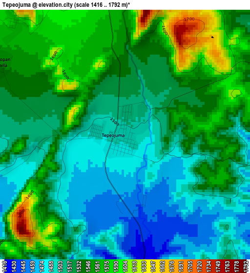
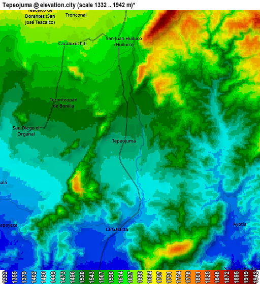
Below is the Elevation map of Tepeojuma, which displays elevation range with different colors. Scale of the first map is from 1416 to 1792 m (4646 to 5879 ft) with average elevation of 1529.7 meters (=5019 ft) [note 1]
These maps also provides idea of topography and contour of this city, they are displayed at different zoom levels. More info about maps, scale and edge coordinates you can find below images.
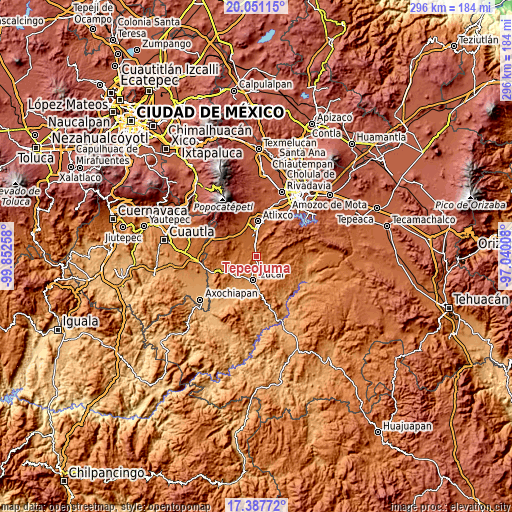
| \ | Map #1 | Map #2 | Topo.Map |
| Scale [m] | 1416..1792 m | 1332..1942 m | × |
| Scale [ft] | 4646..5879 ft | 4370..6371 ft | × |
| Average | 1529.7 m = 5019 ft | 1529.8 m = 5019 ft | × |
| Width | 9.26 km = 5.8 mi | 18.51 km = 11.5 mi | 296.1 km = 184 mi |
| Height | 9.26 km = 5.8 mi | 18.51 km = 11.5 mi | 296.2 km = 184 mi |
| ↑Max Latitude | 18.766294° | 18.807898° | 20.05115° |
| Latitude at center | 18.72468° | 18.72468° | 18.72468° |
| ↓Min Latitude | 18.683056° | 18.641421° | 17.38772° |
| ← Min Longitude | -98.490275° | -98.534221° | -99.85258° |
| Longitude center | -98.44633° | -98.44633° | -98.44633° |
| →Max Longitude | -98.402385° | -98.358439° | -97.04008° |
Nearby cities:
Cities around Tepeojuma sort by population:
• La Galarza elevation 1396 m
6.4 km,  188°
188°
• Cacaloxúchitl 1641 m
8.1 km,  329°
329°
• Huaquechula 1597 m
11.6 km,  296°
296°
• Tlapanalá 1414 m
9.9 km,  251°
251°
• Tezonteopan de Bonilla 1548 m
5.4 km, 298°
• San Juan Epatlán 1353 m
12 km,  139°
139°
• San Diego el Organal 1494 m
7.4 km,  275°
275°
• Teacalco de Dorantes (San José Teacalco) 1684 m
10.9 km,  324°
324°
• Ayotla 1383 m
9.9 km,  128°
128°
• Tronconal 1682 m
9.8 km,  336°
336°
• San Juan Huiluco 1614 m
7.2 km,  357°
357°
• Tepapayeca 1372 m
10.6 km,  235°
235°
Multilingual:
 En español:
San Cristóbal Tepeojuma elevación 1494 m.
 En France:
Tepeojuma élévation 1494 m.
 Auf Deutsch:
Tepeojuma höhe über dem Meeresspiegel ist 1494 m.

Sources and notes:
- [note 1] Map square and city borders are not equal. Map elevation data is calculated only from area inside that square.
- [src 1] Elevation data from geonames database provided with same terms of usage.
- [src 2] The elevation map of Tepeojuma is generated using elevation data from NASA's 3 arcsec (90m) resolution SRTM data.
- [src 3] Base (background) map © OpenStreetMap contributors tiles are generated by Geofabrik and OpenTopoMap.
Copyright & License:
This Tepeojuma Elevation Map is licensed under CC BY-SA. You may reuse any part from this page, if you give a proper credit by linking to this URL:
 More info on terms of use page.