Ayotuxtla elevation
Ayotuxtla (Veracruz, Texcatepec), Mexico elevation is 924 meters and Ayotuxtla elevation in feet is 3031 ft above sea level [src 1]. Ayotuxtla is a populated place (feature code) with elevation that is 390 meters (1280 ft) smaller than average city elevation in Mexico.
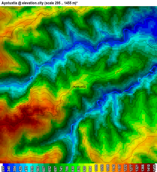
Below is the Elevation map of Ayotuxtla, which displays elevation range with different colors. Scale of the first map is from 295 to 1455 m (968 to 4774 ft) with average elevation of 759.5 meters (=2492 ft) [note 1]
These maps also provides idea of topography and contour of this city, they are displayed at different zoom levels. More info about maps, scale and edge coordinates you can find below images.
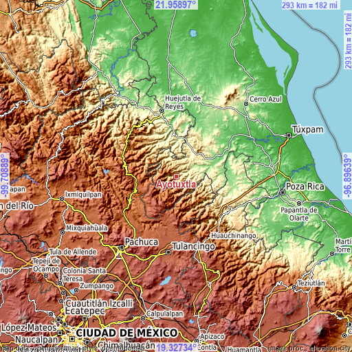
| \ | Map #1 | Topo.Map |
| Scale [m] | 295..1455 m | × |
| Scale [ft] | 968..4774 ft | × |
| Average | 759.5 m = 2492 ft | × |
| Width | 9.14 km = 5.7 mi | 292.6 km = 181.8 mi |
| Height | 9.14 km = 5.7 mi | 292.6 km = 181.8 mi |
| ↑Max Latitude | 20.689967° | 21.95897° |
| Latitude at center | 20.64885° | 20.64885° |
| ↓Min Latitude | 20.607722° | 19.32734° |
| ← Min Longitude | -98.346585° | -99.70889° |
| Longitude center | -98.30264° | -98.30264° |
| →Max Longitude | -98.258695° | -96.89639° |
Nearby cities:
Cities around Ayotuxtla sort by population:
• Huayacocotla elevation 2169 m
22.3 km,  236°
236°
• Otatitlán 549 m
17 km,  95°
95°
• Xochiatipan de Castillo 661 m
20.8 km,  4°
4°
• Tlachichilco 812 m
11.2 km,  105°
105°
• Tenantitla 326 m
21.3 km,  50°
50°
• Pachiquita 692 m
22.2 km,  351°
351°
• Tzicatlán 311 m
7.5 km,  68°
68°
• Texcatepec 1859 m
9.6 km,  222°
222°
• Xococapa 317 m
18.5 km,  344°
344°
• Tetzacual 419 m
14.3 km,  14°
14°
• Ilamatlán 1162 m
20.7 km,  315°
315°
• Zontecomatlán de López y Fuentes 509 m
13.3 km, 341°
Multilingual:
 En español:
Ayotuxtla elevación 924 m.
 En France:
Ayotuxtla élévation 924 m.
 Auf Deutsch:
Ayotuxtla höhe über dem Meeresspiegel ist 924 m.

Sources and notes:
- [note 1] Map square and city borders are not equal. Map elevation data is calculated only from area inside that square.
- [src 1] Elevation data from geonames database provided with same terms of usage.
- [src 2] The elevation map of Ayotuxtla is generated using elevation data from NASA's 3 arcsec (90m) resolution SRTM data.
- [src 3] Base (background) map © OpenStreetMap contributors tiles are generated by Geofabrik and OpenTopoMap.
Copyright & License:
This Ayotuxtla Elevation Map is licensed under CC BY-SA. You may reuse any part from this page, if you give a proper credit by linking to this URL:
 More info on terms of use page.