Huayacocotla elevation
Huayacocotla (Veracruz), Mexico elevation is 2169 meters and Huayacocotla elevation in feet is 7116 ft above sea level [src 1]. Huayacocotla is a seat of a second-order administrative division (feature code) with elevation that is 855 meters (2805 ft) bigger than average city elevation in Mexico.
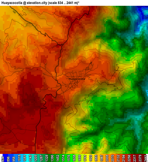
Below is the Elevation map of Huayacocotla, which displays elevation range with different colors. Scale of the first map is from 834 to 2441 m (2736 to 8009 ft) with average elevation of 1898.8 meters (=6230 ft) [note 1]
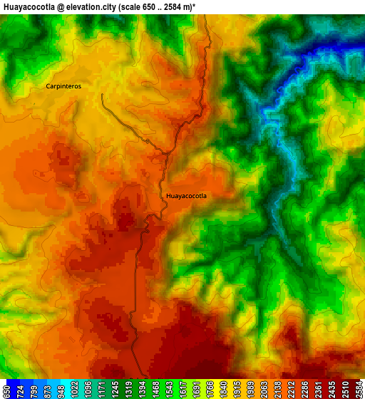
These maps also provides idea of topography and contour of this city, they are displayed at different zoom levels. More info about maps, scale and edge coordinates you can find below images.
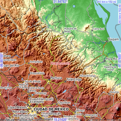
| \ | Map #1 | Map #2 | Topo.Map |
| Scale [m] | 834..2441 m | 650..2584 m | × |
| Scale [ft] | 2736..8009 ft | 2133..8478 ft | × |
| Average | 1898.8 m = 6230 ft | 1835.9 m = 6023 ft | × |
| Width | 9.15 km = 5.7 mi | 18.3 km = 11.4 mi | 292.8 km = 181.9 mi |
| Height | 9.15 km = 5.7 mi | 18.3 km = 11.4 mi | 292.8 km = 181.9 mi |
| ↑Max Latitude | 20.577857° | 20.618993° | 21.84782° |
| Latitude at center | 20.53671° | 20.53671° | 20.53671° |
| ↓Min Latitude | 20.495552° | 20.454383° | 19.21426° |
| ← Min Longitude | -98.524745° | -98.568691° | -99.88705° |
| Longitude center | -98.4808° | -98.4808° | -98.4808° |
| →Max Longitude | -98.436855° | -98.392909° | -97.07455° |
Nearby cities:
Cities around Huayacocotla sort by population:
• Zacualtipán elevation 1990 m
22.2 km,  304°
304°
• Ayotuxtla 924 m
22.3 km,  56°
56°
• Mezquititlán 1376 m
16.3 km,  268°
268°
• Tianguistengo 1645 m
26.5 km,  323°
323°
• Carpinteros 1939 m
8.2 km,  311°
311°
• Palo Bendito 2342 m
9.1 km,  192°
192°
• Tzicatlán 311 m
29.7 km, 59°
• Texcatepec 1859 m
13.2 km,  65°
65°
• Tlahuelompa (San Francisco Tlahuelompa) 1674 m
16 km, 322°
• Ilamatlán 1162 m
27.4 km,  8°
8°
• Zontecomatlán de López y Fuentes 509 m
28.9 km,  29°
29°
• Zacualpan 1691 m
18 km,  129°
129°
Multilingual:
 En español:
Huayacocotla elevación 2169 m.
 En France:
Huayacocotla élévation 2169 m.
 Auf Deutsch:
Huayacocotla höhe über dem Meeresspiegel ist 2169 m.

Sources and notes:
- [note 1] Map square and city borders are not equal. Map elevation data is calculated only from area inside that square.
- [src 1] Elevation data from geonames database provided with same terms of usage.
- [src 2] The elevation map of Huayacocotla is generated using elevation data from NASA's 3 arcsec (90m) resolution SRTM data.
- [src 3] Base (background) map © OpenStreetMap contributors tiles are generated by Geofabrik and OpenTopoMap.
Copyright & License:
This Huayacocotla Elevation Map is licensed under CC BY-SA. You may reuse any part from this page, if you give a proper credit by linking to this URL:
 More info on terms of use page.