Palo Bendito elevation
Palo Bendito (Veracruz, Huayacocotla), Mexico elevation is 2342 meters and Palo Bendito elevation in feet is 7684 ft above sea level [src 1]. Palo Bendito is a populated place (feature code) with elevation that is 1028 meters (3373 ft) bigger than average city elevation in Mexico.
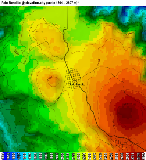
Below is the Elevation map of Palo Bendito, which displays elevation range with different colors. Scale of the first map is from 1564 to 2807 m (5131 to 9209 ft) with average elevation of 2273.7 meters (=7460 ft) [note 1]
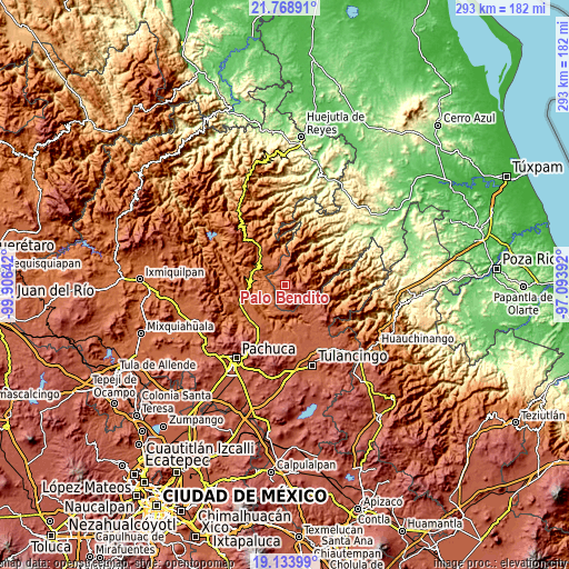
These maps also provides idea of topography and contour of this city, they are displayed at different zoom levels. More info about maps, scale and edge coordinates you can find below images.
| \ | Map #1 | Topo.Map |
| Scale [m] | 1564..2807 m | × |
| Scale [ft] | 5131..9209 ft | × |
| Average | 2273.7 m = 7460 ft | × |
| Width | 9.16 km = 5.7 mi | 293 km = 182.1 mi |
| Height | 9.16 km = 5.7 mi | 293 km = 182.1 mi |
| ↑Max Latitude | 20.498268° | 21.76891° |
| Latitude at center | 20.4571° | 20.4571° |
| ↓Min Latitude | 20.415921° | 19.13399° |
| ← Min Longitude | -98.544115° | -99.90642° |
| Longitude center | -98.50017° | -98.50017° |
| →Max Longitude | -98.456225° | -97.09392° |
Nearby cities:
Cities around Palo Bendito sort by population:
• Atotonilco el Grande elevation 2099 m
25.9 km,  222°
222°
• Huayacocotla 2169 m
9.1 km,  12°
12°
• Mezquititlán 1376 m
16.6 km,  300°
300°
• La Estancia 2030 m
26.4 km,  228°
228°
• Estación de Apulco 2192 m
24.8 km,  140°
140°
• Carpinteros 1939 m
14.9 km,  344°
344°
• Los Sabinos 1985 m
22.1 km, 224°
• Tiltepec 2019 m
24.8 km, 230°
• Tlaxocoyucan 2095 m
25.4 km,  177°
177°
• Texcatepec 1859 m
20 km,  44°
44°
• Tlahuelompa (San Francisco Tlahuelompa) 1674 m
22.9 km, 340°
• Zacualpan 1691 m
16 km,  99°
99°
Multilingual:
 En español:
Palo Bendito elevación 2342 m.
 En France:
Palo Bendito élévation 2342 m.
 Auf Deutsch:
Palo Bendito höhe über dem Meeresspiegel ist 2342 m.

Sources and notes:
- [note 1] Map square and city borders are not equal. Map elevation data is calculated only from area inside that square.
- [src 1] Elevation data from geonames database provided with same terms of usage.
- [src 2] The elevation map of Palo Bendito is generated using elevation data from NASA's 3 arcsec (90m) resolution SRTM data.
- [src 3] Base (background) map © OpenStreetMap contributors tiles are generated by Geofabrik and OpenTopoMap.
Copyright & License:
This Palo Bendito Elevation Map is licensed under CC BY-SA. You may reuse any part from this page, if you give a proper credit by linking to this URL:
 More info on terms of use page.