Tlachichilco elevation
Tlachichilco (Veracruz), Mexico elevation is 812 meters and Tlachichilco elevation in feet is 2664 ft above sea level [src 1]. Tlachichilco is a seat of a second-order administrative division (feature code) with elevation that is 502 meters (1647 ft) smaller than average city elevation in Mexico.
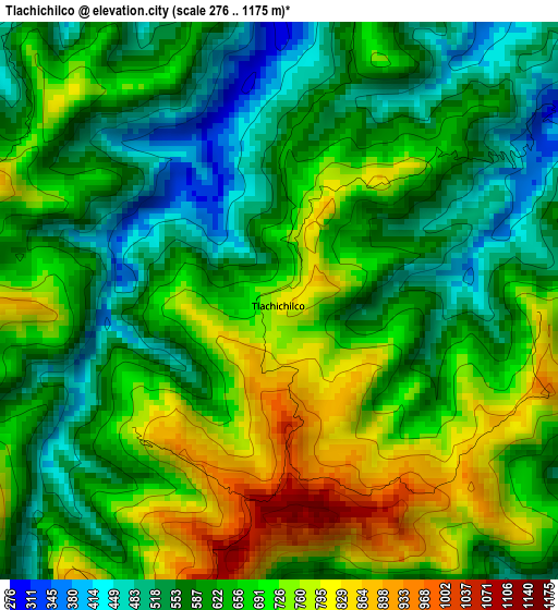
Below is the Elevation map of Tlachichilco, which displays elevation range with different colors. Scale of the first map is from 276 to 1175 m (906 to 3855 ft) with average elevation of 644.5 meters (=2115 ft) [note 1]
These maps also provides idea of topography and contour of this city, they are displayed at different zoom levels. More info about maps, scale and edge coordinates you can find below images.
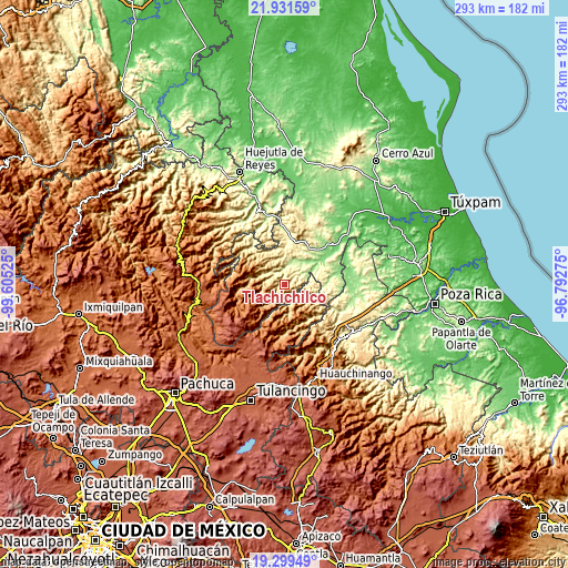
| \ | Map #1 | Topo.Map |
| Scale [m] | 276..1175 m | × |
| Scale [ft] | 906..3855 ft | × |
| Average | 644.5 m = 2115 ft | × |
| Width | 9.15 km = 5.7 mi | 292.7 km = 181.9 mi |
| Height | 9.15 km = 5.7 mi | 292.7 km = 181.9 mi |
| ↑Max Latitude | 20.662354° | 21.93159° |
| Latitude at center | 20.62123° | 20.62123° |
| ↓Min Latitude | 20.580095° | 19.29949° |
| ← Min Longitude | -98.242945° | -99.60525° |
| Longitude center | -98.199° | -98.199° |
| →Max Longitude | -98.155055° | -96.79275° |
Nearby cities:
Cities around Tlachichilco sort by population:
• San Esteban elevation 761 m
16.8 km,  120°
120°
• Ayotuxtla 924 m
11.2 km,  285°
285°
• San Lorenzo Achiotepec 542 m
13.8 km,  101°
101°
• Otatitlán 549 m
6.4 km,  75°
75°
• Ixhuatlán de Madero 260 m
20.9 km,  68°
68°
• Tenantitla 326 m
17.5 km,  18°
18°
• San Andrés 1241 m
17 km,  140°
140°
• Tzicatlán 311 m
7 km,  326°
326°
• Texcatepec 1859 m
17.8 km,  256°
256°
• Huexotitla 227 m
20.1 km,  34°
34°
• Tetzacual 419 m
18.4 km,  336°
336°
• Barrio Aztlán 506 m
21 km,  145°
145°
Multilingual:
 En español:
Tlachichilco elevación 812 m.
 En France:
Tlachichilco élévation 812 m.
 Auf Deutsch:
Tlachichilco höhe über dem Meeresspiegel ist 812 m.

Sources and notes:
- [note 1] Map square and city borders are not equal. Map elevation data is calculated only from area inside that square.
- [src 1] Elevation data from geonames database provided with same terms of usage.
- [src 2] The elevation map of Tlachichilco is generated using elevation data from NASA's 3 arcsec (90m) resolution SRTM data.
- [src 3] Base (background) map © OpenStreetMap contributors tiles are generated by Geofabrik and OpenTopoMap.
Copyright & License:
This Tlachichilco Elevation Map is licensed under CC BY-SA. You may reuse any part from this page, if you give a proper credit by linking to this URL:
 More info on terms of use page.