Bienvenido elevation
Bienvenido (Puebla, Hermenegildo Galeana), Mexico elevation is 783 meters and Bienvenido elevation in feet is 2569 ft above sea level [src 1]. Bienvenido is a populated place (feature code) with elevation that is 531 meters (1742 ft) smaller than average city elevation in Mexico.
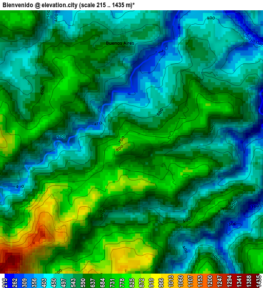
Below is the Elevation map of Bienvenido, which displays elevation range with different colors. Scale of the first map is from 215 to 1435 m (705 to 4708 ft) with average elevation of 597.5 meters (=1960 ft) [note 1]
These maps also provides idea of topography and contour of this city, they are displayed at different zoom levels. More info about maps, scale and edge coordinates you can find below images.
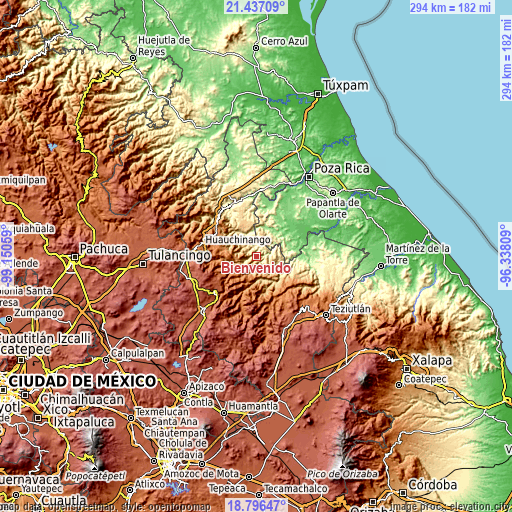
| \ | Map #1 | Topo.Map |
| Scale [m] | 215..1435 m | × |
| Scale [ft] | 705..4708 ft | × |
| Average | 597.5 m = 1960 ft | × |
| Width | 9.18 km = 5.7 mi | 293.6 km = 182.4 mi |
| Height | 9.18 km = 5.7 mi | 293.6 km = 182.4 mi |
| ↑Max Latitude | 20.163607° | 21.43709° |
| Latitude at center | 20.12235° | 20.12235° |
| ↓Min Latitude | 20.081082° | 18.79647° |
| ← Min Longitude | -97.788285° | -99.15059° |
| Longitude center | -97.74434° | -97.74434° |
| →Max Longitude | -97.700395° | -96.33809° |
Nearby cities:
Cities around Bienvenido sort by population:
• Filomeno Mata elevation 705 m
9.6 km,  26°
26°
• Amixtlán 1248 m
10.1 km,  214°
214°
• Leacaman 787 m
10.9 km,  104°
104°
• Olintla 734 m
6.7 km,  109°
109°
• Jopala 646 m
7.1 km,  49°
49°
• Buenos Aires 585 m
3.5 km,  353°
353°
• Vicente Guerrero 526 m
9.4 km,  89°
89°
• Camocuautla 716 m
9.5 km,  188°
188°
• Chipahuatlán 942 m
9 km,  139°
139°
• Lacapan Camallagne 535 m
9.5 km, 85°
• Cuautotola 1365 m
8.2 km,  223°
223°
• Tlamaya Grande 734 m
6.7 km,  293°
293°
Multilingual:
 En español:
Bienvenido elevación 783 m.
 En France:
Bienvenido élévation 783 m.
 Auf Deutsch:
Bienvenido höhe über dem Meeresspiegel ist 783 m.

Sources and notes:
- [note 1] Map square and city borders are not equal. Map elevation data is calculated only from area inside that square.
- [src 1] Elevation data from geonames database provided with same terms of usage.
- [src 2] The elevation map of Bienvenido is generated using elevation data from NASA's 3 arcsec (90m) resolution SRTM data.
- [src 3] Base (background) map © OpenStreetMap contributors tiles are generated by Geofabrik and OpenTopoMap.
Copyright & License:
This Bienvenido Elevation Map is licensed under CC BY-SA. You may reuse any part from this page, if you give a proper credit by linking to this URL:
 More info on terms of use page.