Jopala elevation
Jopala (Puebla), Mexico elevation is 646 meters and Jopala elevation in feet is 2119 ft above sea level [src 1]. Jopala is a populated place (feature code) with elevation that is 668 meters (2192 ft) smaller than average city elevation in Mexico.
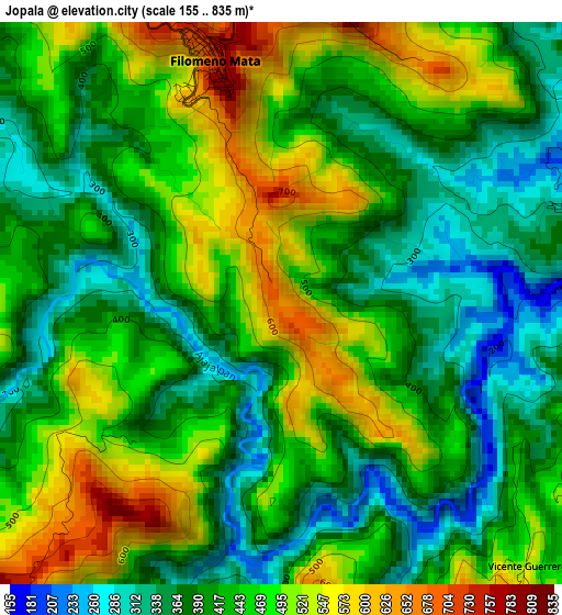
Below is the Elevation map of Jopala, which displays elevation range with different colors. Scale of the first map is from 155 to 835 m (509 to 2740 ft) with average elevation of 436.8 meters (=1433 ft) [note 1]
These maps also provides idea of topography and contour of this city, they are displayed at different zoom levels. More info about maps, scale and edge coordinates you can find below images.
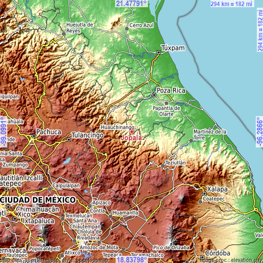
| \ | Map #1 | Topo.Map |
| Scale [m] | 155..835 m | × |
| Scale [ft] | 509..2740 ft | × |
| Average | 436.8 m = 1433 ft | × |
| Width | 9.17 km = 5.7 mi | 293.5 km = 182.4 mi |
| Height | 9.17 km = 5.7 mi | 293.6 km = 182.4 mi |
| ↑Max Latitude | 20.204777° | 21.47791° |
| Latitude at center | 20.16353° | 20.16353° |
| ↓Min Latitude | 20.122273° | 18.83798° |
| ← Min Longitude | -97.736795° | -99.0991° |
| Longitude center | -97.69285° | -97.69285° |
| →Max Longitude | -97.648905° | -96.2866° |
Nearby cities:
Cities around Jopala sort by population:
• Filomeno Mata elevation 705 m
4.2 km,  344°
344°
• Mecatlán 855 m
5.3 km,  12°
12°
• Cinco de Mayo 616 m
7.5 km,  118°
118°
• Olintla 734 m
6.9 km,  172°
172°
• Buenos Aires 585 m
5.9 km,  258°
258°
• Ricardo Flores Magón 335 m
8.3 km,  67°
67°
• Vicente Guerrero 526 m
6 km,  137°
137°
• Putlunichuchut (Vista Hermosa) 591 m
8.1 km,  95°
95°
• Cerro Grande 326 m
8.4 km, 7°
• Bienvenido 783 m
7.1 km,  229°
229°
• Lacapan Camallagne 535 m
5.7 km,  133°
133°
• Rancho Alegre 464 m
7.4 km,  49°
49°
Multilingual:
 En español:
Jopala elevación 646 m.
 En France:
Jopala élévation 646 m.


Sources and notes:
- [note 1] Map square and city borders are not equal. Map elevation data is calculated only from area inside that square.
- [src 1] Elevation data from geonames database provided with same terms of usage.
- [src 2] The elevation map of Jopala is generated using elevation data from NASA's 3 arcsec (90m) resolution SRTM data.
- [src 3] Base (background) map © OpenStreetMap contributors tiles are generated by Geofabrik and OpenTopoMap.
Copyright & License:
This Jopala Elevation Map is licensed under CC BY-SA. You may reuse any part from this page, if you give a proper credit by linking to this URL:
 More info on terms of use page.