Chalmita elevation
Chalmita (State of Mexico, Ocuilan), Mexico elevation is 1796 meters and Chalmita elevation in feet is 5892 ft above sea level [src 1]. Chalmita is a populated place (feature code) with elevation that is 482 meters (1581 ft) bigger than average city elevation in Mexico.
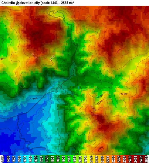
Below is the Elevation map of Chalmita, which displays elevation range with different colors. Scale of the first map is from 1443 to 2535 m (4734 to 8317 ft) with average elevation of 2016.6 meters (=6616 ft) [note 1]
These maps also provides idea of topography and contour of this city, they are displayed at different zoom levels. More info about maps, scale and edge coordinates you can find below images.
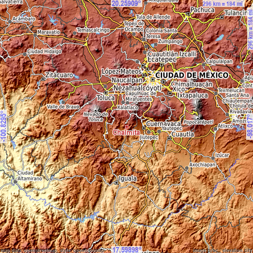
| \ | Map #1 | Topo.Map |
| Scale [m] | 1443..2535 m | × |
| Scale [ft] | 4734..8317 ft | × |
| Average | 2016.6 m = 6616 ft | × |
| Width | 9.24 km = 5.7 mi | 295.8 km = 183.8 mi |
| Height | 9.24 km = 5.7 mi | 295.8 km = 183.8 mi |
| ↑Max Latitude | 18.975892° | 20.25909° |
| Latitude at center | 18.93433° | 18.93433° |
| ↓Min Latitude | 18.892757° | 17.59898° |
| ← Min Longitude | -99.467195° | -100.8295° |
| Longitude center | -99.42325° | -99.42325° |
| →Max Longitude | -99.379305° | -98.017° |
Nearby cities:
Cities around Chalmita sort by population:
• Malinalco elevation 1748 m
7.8 km,  281°
281°
• San Miguel Tecomatlán 2087 m
12.1 km,  293°
293°
• Santa Mónica 2331 m
6.5 km,  359°
359°
• San Simón el Alto 2412 m
10.9 km,  309°
309°
• San José Tenería (Tenería) 2061 m
12.7 km, 278°
• Ocuilan de Arteaga 2353 m
4.9 km,  4°
4°
• Chalma 1664 m
1.3 km,  250°
250°
• Santa Lucía 2700 m
11 km,  20°
20°
• Santa Ana 2377 m
6 km,  10°
10°
• Plaza Nueva 1695 m
1.3 km, 245°
• Colonia Doctor Gustavo Baz 2585 m
9.2 km, 17°
• Jalmolonga (La Hacienda) 1573 m
7.7 km,  256°
256°
Multilingual:
 En español:
Chalmita elevación 1796 m.
 En France:
Chalmita élévation 1796 m.
 Auf Deutsch:
Chalmita höhe über dem Meeresspiegel ist 1796 m.

Sources and notes:
- [note 1] Map square and city borders are not equal. Map elevation data is calculated only from area inside that square.
- [src 1] Elevation data from geonames database provided with same terms of usage.
- [src 2] The elevation map of Chalmita is generated using elevation data from NASA's 3 arcsec (90m) resolution SRTM data.
- [src 3] Base (background) map © OpenStreetMap contributors tiles are generated by Geofabrik and OpenTopoMap.
Copyright & License:
This Chalmita Elevation Map is licensed under CC BY-SA. You may reuse any part from this page, if you give a proper credit by linking to this URL:
 More info on terms of use page.