Malinalco elevation
Malinalco (State of Mexico), Mexico elevation is 1748 meters and Malinalco elevation in feet is 5735 ft above sea level [src 1]. Malinalco is a seat of a second-order administrative division (feature code) with elevation that is 434 meters (1424 ft) bigger than average city elevation in Mexico.
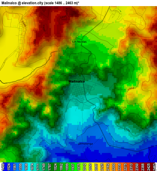
Below is the Elevation map of Malinalco, which displays elevation range with different colors. Scale of the first map is from 1486 to 2463 m (4875 to 8081 ft) with average elevation of 1929.5 meters (=6330 ft) [note 1]
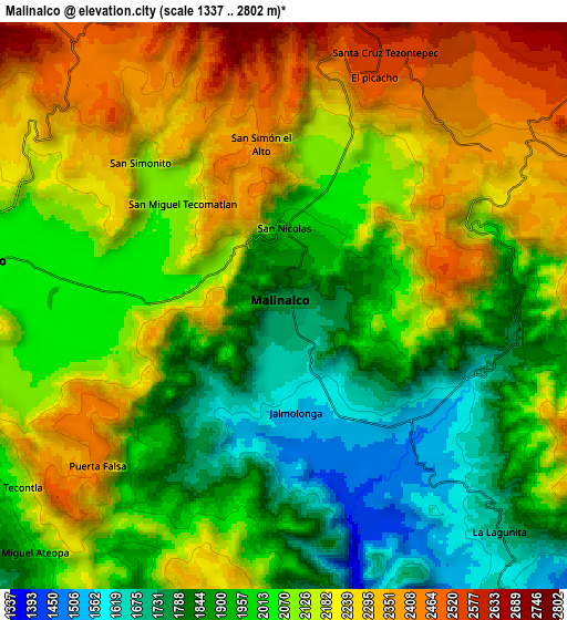
These maps also provides idea of topography and contour of this city, they are displayed at different zoom levels. More info about maps, scale and edge coordinates you can find below images.
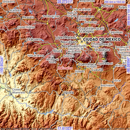
| \ | Map #1 | Map #2 | Topo.Map |
| Scale [m] | 1486..2463 m | 1337..2802 m | × |
| Scale [ft] | 4875..8081 ft | 4386..9193 ft | × |
| Average | 1929.5 m = 6330 ft | 2073.2 m = 6802 ft | × |
| Width | 9.24 km = 5.7 mi | 18.49 km = 11.5 mi | 295.8 km = 183.8 mi |
| Height | 9.24 km = 5.7 mi | 18.49 km = 11.5 mi | 295.8 km = 183.8 mi |
| ↑Max Latitude | 18.990029° | 19.031577° | 20.27311° |
| Latitude at center | 18.94847° | 18.94847° | 18.94847° |
| ↓Min Latitude | 18.906901° | 18.865321° | 17.61323° |
| ← Min Longitude | -99.540135° | -99.584081° | -100.90244° |
| Longitude center | -99.49619° | -99.49619° | -99.49619° |
| →Max Longitude | -99.452245° | -99.408299° | -98.08994° |
Nearby cities:
Cities around Malinalco sort by population:
• San Miguel Tecomatlán elevation 2087 m
4.8 km,  314°
314°
• San Simón el Alto 2412 m
5.4 km,  351°
351°
• Colonia Emiliano Zapata Ejido de Tenancingo 2043 m
6.6 km,  274°
274°
• San José Tenería (Tenería) 2061 m
4.9 km, 272°
• San Simonito 2125 m
6.6 km,  316°
316°
• Chalma 1664 m
6.7 km,  107°
107°
• San Nicolás 2051 m
7.8 km,  257°
257°
• Chalmita 1796 m
7.8 km,  101°
101°
• Tepoxtepec 2052 m
6.5 km,  284°
284°
• Plaza Nueva 1695 m
6.8 km, 108°
• El Carmen (El Desierto del Carmen) 2428 m
7.1 km,  243°
243°
• Jalmolonga (La Hacienda) 1573 m
3.4 km,  176°
176°
Multilingual:
 En español:
Malinalco elevación 1748 m.
 En France:
Malinalco élévation 1748 m.
 Auf Deutsch:
Malinalco höhe über dem Meeresspiegel ist 1748 m.

Sources and notes:
- [note 1] Map square and city borders are not equal. Map elevation data is calculated only from area inside that square.
- [src 1] Elevation data from geonames database provided with same terms of usage.
- [src 2] The elevation map of Malinalco is generated using elevation data from NASA's 3 arcsec (90m) resolution SRTM data.
- [src 3] Base (background) map © OpenStreetMap contributors tiles are generated by Geofabrik and OpenTopoMap.
Copyright & License:
This Malinalco Elevation Map is licensed under CC BY-SA. You may reuse any part from this page, if you give a proper credit by linking to this URL:
 More info on terms of use page.