San José Tenería (Tenería) elevation
San José Tenería (Tenería) (State of Mexico, Tenancingo), Mexico elevation is 2061 meters and San José Tenería (Tenería) elevation in feet is 6762 ft above sea level [src 1]. San José Tenería (Tenería) is a populated place (feature code) with elevation that is 747 meters (2451 ft) bigger than average city elevation in Mexico.
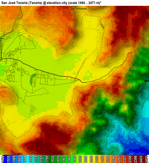
Below is the Elevation map of San José Tenería (Tenería), which displays elevation range with different colors. Scale of the first map is from 1494 to 2471 m (4902 to 8107 ft) with average elevation of 2076.7 meters (=6813 ft) [note 1]
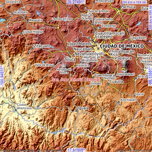
These maps also provides idea of topography and contour of this city, they are displayed at different zoom levels. More info about maps, scale and edge coordinates you can find below images.
| \ | Map #1 | Topo.Map |
| Scale [m] | 1494..2471 m | × |
| Scale [ft] | 4902..8107 ft | × |
| Average | 2076.7 m = 6813 ft | × |
| Width | 9.24 km = 5.7 mi | 295.7 km = 183.7 mi |
| Height | 9.24 km = 5.7 mi | 295.8 km = 183.8 mi |
| ↑Max Latitude | 18.991838° | 20.27491° |
| Latitude at center | 18.95028° | 18.95028° |
| ↓Min Latitude | 18.908711° | 17.61505° |
| ← Min Longitude | -99.587005° | -100.94931° |
| Longitude center | -99.54306° | -99.54306° |
| →Max Longitude | -99.499115° | -98.13681° |
Nearby cities:
Cities around San José Tenería (Tenería) sort by population:
• San José el Cuartel elevation 2037 m
3.7 km,  286°
286°
• Zumpahuacán 2376 m
4.5 km,  212°
212°
• La Trinidad 2034 m
4.4 km, 294°
• San Miguel Tecomatlán 2087 m
3.5 km,  25°
25°
• La Ciénega 2029 m
4.1 km,  279°
279°
• Colonia Emiliano Zapata Ejido de Tenancingo 2043 m
1.7 km, 282°
• Colonia San Ramón 2033 m
3.7 km,  303°
303°
• San Nicolás 2051 m
3.3 km,  234°
234°
• Tepoxtepec 2052 m
2 km,  314°
314°
• Chalchihuapan 2060 m
4.5 km, 311°
• Pueblo Nuevo 2056 m
4.3 km,  266°
266°
• El Carmen (El Desierto del Carmen) 2428 m
3.6 km,  203°
203°
Multilingual:
 En español:
San José Tenería (Tenería) elevación 2061 m.
 En France:
San José Tenería (Tenería) élévation 2061 m.
 Auf Deutsch:
San José Tenería (Tenería) höhe über dem Meeresspiegel ist 2061 m.
 На русском:
San José Tenería (Tenería) высота над уровнем моря 2061 м
Sources and notes:
- [note 1] Map square and city borders are not equal. Map elevation data is calculated only from area inside that square.
- [src 1] Elevation data from geonames database provided with same terms of usage.
- [src 2] The elevation map of San José Tenería (Tenería) is generated using elevation data from NASA's 3 arcsec (90m) resolution SRTM data.
- [src 3] Base (background) map © OpenStreetMap contributors tiles are generated by Geofabrik and OpenTopoMap.
Copyright & License:
This San José Tenería (Tenería) Elevation Map is licensed under CC BY-SA. You may reuse any part from this page, if you give a proper credit by linking to this URL:
 More info on terms of use page.