Chontalpa elevation
Chontalpa (Tabasco, Huimanguillo), Mexico elevation is 54 meters and Chontalpa elevation in feet is 177 ft above sea level [src 1]. Chontalpa is a populated place (feature code) with elevation that is 1260 meters (4134 ft) smaller than average city elevation in Mexico.
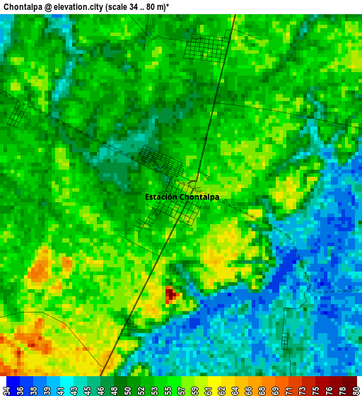
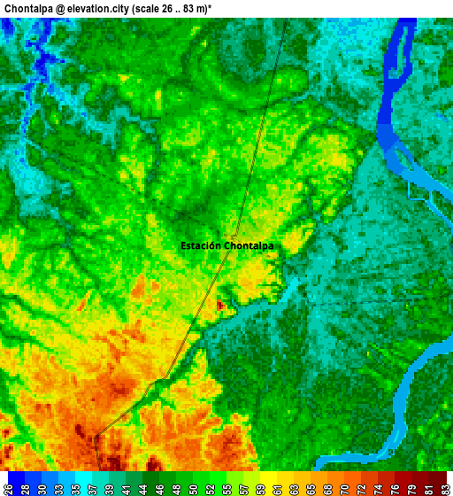
Below is the Elevation map of Chontalpa, which displays elevation range with different colors. Scale of the first map is from 34 to 80 m (112 to 262 ft) with average elevation of 51.5 meters (=169 ft) [note 1]
These maps also provides idea of topography and contour of this city, they are displayed at different zoom levels. More info about maps, scale and edge coordinates you can find below images.
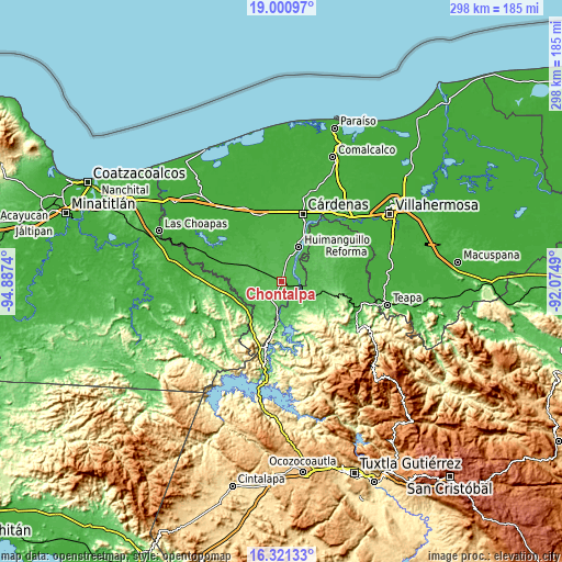
| \ | Map #1 | Map #2 | Topo.Map |
| Scale [m] | 34..80 m | 26..83 m | × |
| Scale [ft] | 112..262 ft | 85..272 ft | × |
| Average | 51.5 m = 169 ft | 48.9 m = 160 ft | × |
| Width | 9.31 km = 5.8 mi | 18.62 km = 11.6 mi | 297.9 km = 185.1 mi |
| Height | 9.31 km = 5.8 mi | 18.62 km = 11.6 mi | 298 km = 185.2 mi |
| ↑Max Latitude | 17.708008° | 17.749866° | 19.00097° |
| Latitude at center | 17.66614° | 17.66614° | 17.66614° |
| ↓Min Latitude | 17.624262° | 17.582375° | 16.32133° |
| ← Min Longitude | -93.525095° | -93.569041° | -94.8874° |
| Longitude center | -93.48115° | -93.48115° | -93.48115° |
| →Max Longitude | -93.437205° | -93.393259° | -92.0749° |
Nearby cities:
Cities around Chontalpa sort by population:
• Huimanguillo elevation 37 m
21 km,  27°
27°
• C-41 (Licenciado Carlos A. Madrazo) 29 m
28.8 km,  6°
6°
• Libertad 36 m
19.8 km,  19°
19°
• Ocuapan 41 m
20.9 km,  357°
357°
• Mecatepec 33 m
25.3 km,  349°
349°
• Nuevo Juan del Grijalva 286 m
29 km,  156°
156°
• Plan de Ayala 60 m
21.4 km,  181°
181°
• Nuevo Xochimilco 270 m
26.4 km,  153°
153°
• Estación San Manuel 50 m
10.4 km,  98°
98°
• El Triunfo 1ra. Sección (Cardona) 83 m
27.1 km, 103°
• El Dorado 33 m
27 km, 26°
• Caobanal 1ra. Sección (Mezcalapa) 44 m
9.4 km, 102°
Multilingual:
 En español:
Chontalpa elevación 54 m.
 En France:
Chontalpa élévation 54 m.
 Auf Deutsch:
Chontalpa höhe über dem Meeresspiegel ist 54 m.

Sources and notes:
- [note 1] Map square and city borders are not equal. Map elevation data is calculated only from area inside that square.
- [src 1] Elevation data from geonames database provided with same terms of usage.
- [src 2] The elevation map of Chontalpa is generated using elevation data from NASA's 3 arcsec (90m) resolution SRTM data.
- [src 3] Base (background) map © OpenStreetMap contributors tiles are generated by Geofabrik and OpenTopoMap.
Copyright & License:
This Chontalpa Elevation Map is licensed under CC BY-SA. You may reuse any part from this page, if you give a proper credit by linking to this URL:
 More info on terms of use page.