Cotaxtla elevation
Cotaxtla (Veracruz), Mexico elevation is 43 meters and Cotaxtla elevation in feet is 141 ft above sea level [src 1]. Cotaxtla is a populated place (feature code) with elevation that is 1271 meters (4170 ft) smaller than average city elevation in Mexico.
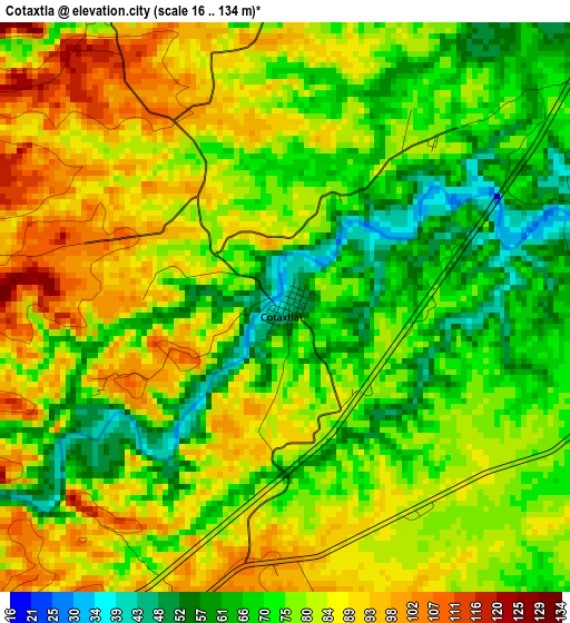
Below is the Elevation map of Cotaxtla, which displays elevation range with different colors. Scale of the first map is from 16 to 134 m (52 to 440 ft) with average elevation of 78.3 meters (=257 ft) [note 1]
These maps also provides idea of topography and contour of this city, they are displayed at different zoom levels. More info about maps, scale and edge coordinates you can find below images.
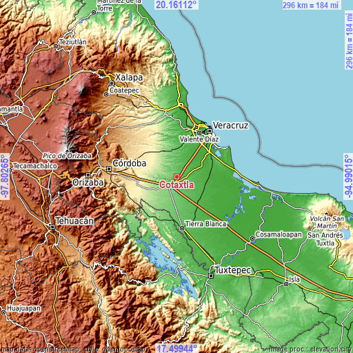
| \ | Map #1 | Topo.Map |
| Scale [m] | 16..134 m | × |
| Scale [ft] | 52..440 ft | × |
| Average | 78.3 m = 257 ft | × |
| Width | 9.25 km = 5.7 mi | 296 km = 183.9 mi |
| Height | 9.25 km = 5.7 mi | 296 km = 183.9 mi |
| ↑Max Latitude | 18.877137° | 20.16112° |
| Latitude at center | 18.83555° | 18.83555° |
| ↓Min Latitude | 18.793953° | 17.49944° |
| ← Min Longitude | -96.440345° | -97.80265° |
| Longitude center | -96.3964° | -96.3964° |
| →Max Longitude | -96.352455° | -94.99015° |
Nearby cities:
Cities around Cotaxtla sort by population:
• Soledad de Doblado elevation 102 m
23.6 km,  353°
353°
• Piedras Negras 33 m
24.7 km,  107°
107°
• Manlio Fabio Altamirano 55 m
29.5 km,  12°
12°
• Jamapa 23 m
28.1 km,  35°
35°
• Joachín 47 m
27.8 km,  141°
141°
• La Tinaja 136 m
10.9 km,  220°
220°
• Rodríguez Tejeda 107 m
22.7 km,  185°
185°
• La Capilla 30 m
17.6 km,  68°
68°
• Huixcolotla 142 m
21.7 km,  209°
209°
• Ejidal 24 m
19.5 km, 67°
• Rincón de Barrabás 223 m
24 km,  322°
322°
• El Palmar 290 m
28.6 km,  262°
262°
Multilingual:
 En español:
Cotaxtla elevación 43 m.
 En France:
Cotaxtla élévation 43 m.


Sources and notes:
- [note 1] Map square and city borders are not equal. Map elevation data is calculated only from area inside that square.
- [src 1] Elevation data from geonames database provided with same terms of usage.
- [src 2] The elevation map of Cotaxtla is generated using elevation data from NASA's 3 arcsec (90m) resolution SRTM data.
- [src 3] Base (background) map © OpenStreetMap contributors tiles are generated by Geofabrik and OpenTopoMap.
Copyright & License:
This Cotaxtla Elevation Map is licensed under CC BY-SA. You may reuse any part from this page, if you give a proper credit by linking to this URL:
 More info on terms of use page.