La Tinaja elevation
La Tinaja (Veracruz, Cotaxtla), Mexico elevation is 136 meters and La Tinaja elevation in feet is 446 ft above sea level [src 1]. La Tinaja is a populated place (feature code) with elevation that is 1178 meters (3865 ft) smaller than average city elevation in Mexico.
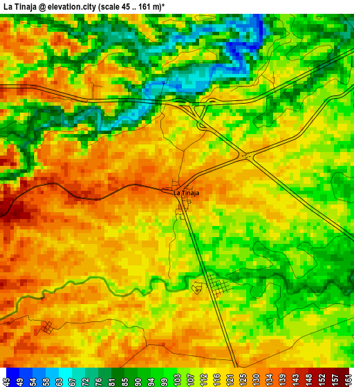
Below is the Elevation map of La Tinaja, which displays elevation range with different colors. Scale of the first map is from 45 to 161 m (148 to 528 ft) with average elevation of 111.2 meters (=365 ft) [note 1]
These maps also provides idea of topography and contour of this city, they are displayed at different zoom levels. More info about maps, scale and edge coordinates you can find below images.
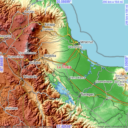
| \ | Map #1 | Topo.Map |
| Scale [m] | 45..161 m | × |
| Scale [ft] | 148..528 ft | × |
| Average | 111.2 m = 365 ft | × |
| Width | 9.25 km = 5.7 mi | 296.1 km = 184 mi |
| Height | 9.25 km = 5.7 mi | 296.1 km = 184 mi |
| ↑Max Latitude | 18.802425° | 20.08699° |
| Latitude at center | 18.76082° | 18.76082° |
| ↓Min Latitude | 18.719204° | 17.42414° |
| ← Min Longitude | -96.506775° | -97.86908° |
| Longitude center | -96.46283° | -96.46283° |
| →Max Longitude | -96.418885° | -95.05658° |
Nearby cities:
Cities around La Tinaja sort by population:
• Cuitláhuac elevation 378 m
28 km,  282°
282°
• Tetela 92 m
28 km,  179°
179°
• Joachín 47 m
27.7 km,  119°
119°
• Rodríguez Tejeda 107 m
15.2 km,  160°
160°
• Mata Tenatito (Casco Hacienda) 261 m
21.5 km,  258°
258°
• La Capilla 30 m
27.6 km,  57°
57°
• Almolonga 198 m
26.9 km,  230°
230°
• Huixcolotla 142 m
11.2 km,  199°
199°
• Cotaxtla 43 m
10.9 km,  40°
40°
• Loma Angosta 292 m
22.6 km, 276°
• El Palmar 290 m
21.9 km, 282°
• Mata Naranjo 336 m
26.4 km,  274°
274°
Multilingual:
 En español:
La Tinaja elevación 136 m.
 En France:
La Tinaja élévation 136 m.
 Auf Deutsch:
La Tinaja höhe über dem Meeresspiegel ist 136 m.

Sources and notes:
- [note 1] Map square and city borders are not equal. Map elevation data is calculated only from area inside that square.
- [src 1] Elevation data from geonames database provided with same terms of usage.
- [src 2] The elevation map of La Tinaja is generated using elevation data from NASA's 3 arcsec (90m) resolution SRTM data.
- [src 3] Base (background) map © OpenStreetMap contributors tiles are generated by Geofabrik and OpenTopoMap.
Copyright & License:
This La Tinaja Elevation Map is licensed under CC BY-SA. You may reuse any part from this page, if you give a proper credit by linking to this URL:
 More info on terms of use page.