Cuentepec elevation
Cuentepec (Morelos, Temixco), Mexico elevation is 1490 meters and Cuentepec elevation in feet is 4888 ft above sea level [src 1]. Cuentepec is a populated place (feature code) with elevation that is 176 meters (577 ft) bigger than average city elevation in Mexico.
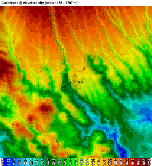
Below is the Elevation map of Cuentepec, which displays elevation range with different colors. Scale of the first map is from 1155 to 1707 m (3789 to 5600 ft) with average elevation of 1462.2 meters (=4797 ft) [note 1]
These maps also provides idea of topography and contour of this city, they are displayed at different zoom levels. More info about maps, scale and edge coordinates you can find below images.
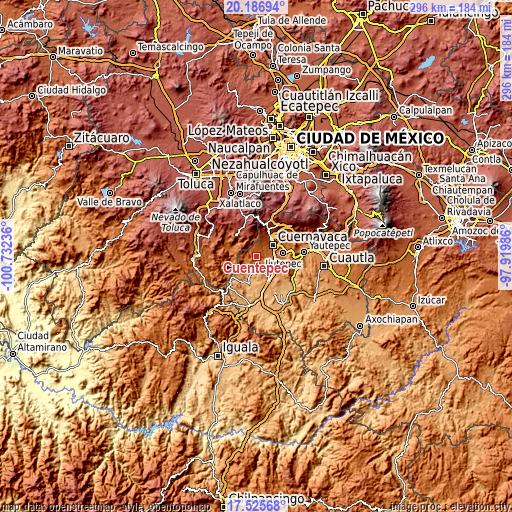
| \ | Map #1 | Topo.Map |
| Scale [m] | 1155..1707 m | × |
| Scale [ft] | 3789..5600 ft | × |
| Average | 1462.2 m = 4797 ft | × |
| Width | 9.25 km = 5.7 mi | 295.9 km = 183.9 mi |
| Height | 9.25 km = 5.7 mi | 295.9 km = 183.9 mi |
| ↑Max Latitude | 18.90317° | 20.18694° |
| Latitude at center | 18.86159° | 18.86159° |
| ↓Min Latitude | 18.819999° | 17.52568° |
| ← Min Longitude | -99.370055° | -100.73236° |
| Longitude center | -99.32611° | -99.32611° |
| →Max Longitude | -99.282165° | -97.91986° |
Nearby cities:
Cities around Cuentepec sort by population:
• Cuernavaca elevation 1540 m
12.3 km,  54°
54°
• Temixco 1268 m
10.6 km,  95°
95°
• Xochitepec 1123 m
13.5 km,  131°
131°
• Tres de Mayo 1379 m
12.4 km,  86°
86°
• Unidad Habitacional José María Morelos y Pavón 1273 m
8.1 km,  124°
124°
• Fraccionamiento Lomas de Ahuatlán 1745 m
12.6 km,  35°
35°
• Miacatlán 1032 m
11.6 km,  197°
197°
• Chalmita 1796 m
13 km,  308°
308°
• El Mirador 1064 m
10.2 km,  189°
189°
• Xochicalco (Cirenio Longares) 1183 m
8.7 km,  161°
161°
• Plaza Nueva 1695 m
13.7 km,  303°
303°
• El Rodeo 1119 m
9.2 km,  177°
177°
Multilingual:
 En español:
Cuentepec elevación 1490 m.
 En France:
Cuentepec élévation 1490 m.
 Auf Deutsch:
Cuentepec höhe über dem Meeresspiegel ist 1490 m.

Sources and notes:
- [note 1] Map square and city borders are not equal. Map elevation data is calculated only from area inside that square.
- [src 1] Elevation data from geonames database provided with same terms of usage.
- [src 2] The elevation map of Cuentepec is generated using elevation data from NASA's 3 arcsec (90m) resolution SRTM data.
- [src 3] Base (background) map © OpenStreetMap contributors tiles are generated by Geofabrik and OpenTopoMap.
Copyright & License:
This Cuentepec Elevation Map is licensed under CC BY-SA. You may reuse any part from this page, if you give a proper credit by linking to this URL:
 More info on terms of use page.