Xochitepec elevation
Xochitepec (Morelos), Mexico elevation is 1123 meters and Xochitepec elevation in feet is 3684 ft above sea level [src 1]. Xochitepec is a seat of a second-order administrative division (feature code) with elevation that is 191 meters (627 ft) smaller than average city elevation in Mexico.
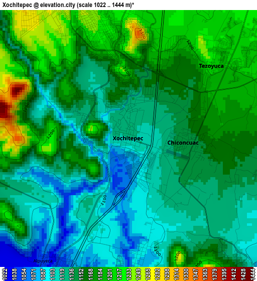
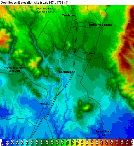
Below is the Elevation map of Xochitepec, which displays elevation range with different colors. Scale of the first map is from 1022 to 1444 m (3353 to 4738 ft) with average elevation of 1151 meters (=3776 ft) [note 1]
These maps also provides idea of topography and contour of this city, they are displayed at different zoom levels. More info about maps, scale and edge coordinates you can find below images.
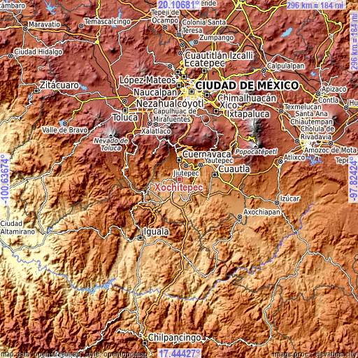
| \ | Map #1 | Map #2 | Topo.Map |
| Scale [m] | 1022..1444 m | 947..1701 m | × |
| Scale [ft] | 3353..4738 ft | 3107..5581 ft | × |
| Average | 1151 m = 3776 ft | 1184.9 m = 3887 ft | × |
| Width | 9.25 km = 5.7 mi | 18.5 km = 11.5 mi | 296 km = 183.9 mi |
| Height | 9.25 km = 5.7 mi | 18.5 km = 11.5 mi | 296.1 km = 184 mi |
| ↑Max Latitude | 18.8224° | 18.863991° | 20.10681° |
| Latitude at center | 18.7808° | 18.7808° | 18.7808° |
| ↓Min Latitude | 18.739189° | 18.697568° | 17.44427° |
| ← Min Longitude | -99.274435° | -99.318381° | -100.63674° |
| Longitude center | -99.23049° | -99.23049° | -99.23049° |
| →Max Longitude | -99.186545° | -99.142599° | -97.82424° |
Nearby cities:
Cities around Xochitepec sort by population:
• Temixco elevation 1268 m
8 km,  3°
3°
• Emiliano Zapata 1272 m
8.2 km,  35°
35°
• Unidad Habitacional José María Morelos y Pavón 1273 m
5.5 km,  322°
322°
• Alpuyeca 1044 m
5.5 km,  213°
213°
• Chiconcuac 1153 m
2.5 km,  84°
84°
• Tezoyuca 1216 m
4 km,  48°
48°
• Atlacholoaya 1087 m
4.3 km,  174°
174°
• Tetecalita 1182 m
5.8 km,  104°
104°
• Ninguno [Centro de Readaptación Social de Atlacholoaya] 1090 m
2.6 km,  177°
177°
• Tepetzingo 1209 m
5.6 km, 84°
• Temimilcingo 1021 m
9.3 km,  127°
127°
• Xochicalco (Cirenio Longares) 1183 m
7.3 km,  275°
275°
Multilingual:
 En español:
Xochitepec elevación 1123 m.
 En France:
Xochitepec élévation 1123 m.
 Auf Deutsch:
Xochitepec höhe über dem Meeresspiegel ist 1123 m.

Sources and notes:
- [note 1] Map square and city borders are not equal. Map elevation data is calculated only from area inside that square.
- [src 1] Elevation data from geonames database provided with same terms of usage.
- [src 2] The elevation map of Xochitepec is generated using elevation data from NASA's 3 arcsec (90m) resolution SRTM data.
- [src 3] Base (background) map © OpenStreetMap contributors tiles are generated by Geofabrik and OpenTopoMap.
Copyright & License:
This Xochitepec Elevation Map is licensed under CC BY-SA. You may reuse any part from this page, if you give a proper credit by linking to this URL:
 More info on terms of use page.