Cuetzalan elevation
Cuetzalan (Puebla, Cuetzalan del Progreso), Mexico elevation is 979 meters and Cuetzalan elevation in feet is 3212 ft above sea level [src 1]. Cuetzalan is a seat of a second-order administrative division (feature code) with elevation that is 335 meters (1099 ft) smaller than average city elevation in Mexico.
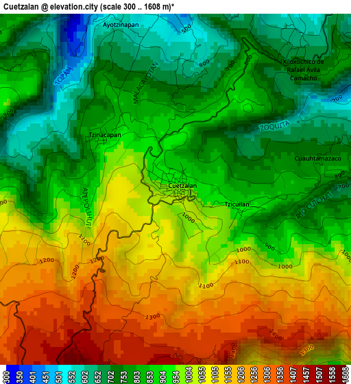
Below is the Elevation map of Cuetzalan, which displays elevation range with different colors. Scale of the first map is from 300 to 1608 m (984 to 5276 ft) with average elevation of 939.4 meters (=3082 ft) [note 1]
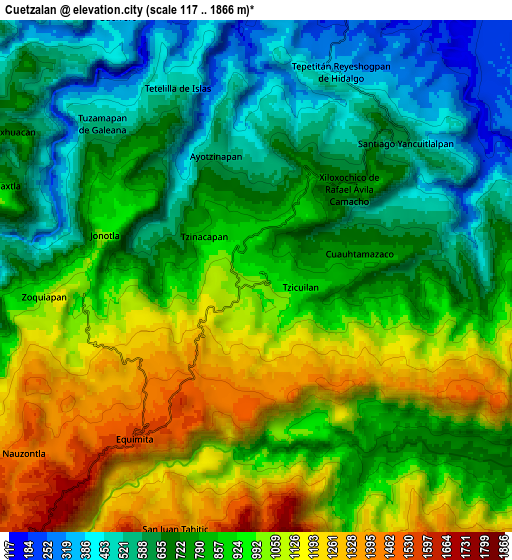
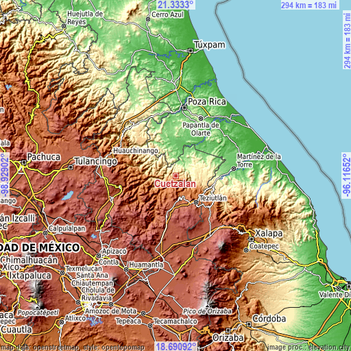
These maps also provides idea of topography and contour of this city, they are displayed at different zoom levels. More info about maps, scale and edge coordinates you can find below images.
| \ | Map #1 | Map #2 | Topo.Map |
| Scale [m] | 300..1608 m | 117..1866 m | × |
| Scale [ft] | 984..5276 ft | 384..6122 ft | × |
| Average | 939.4 m = 3082 ft | 846.8 m = 2778 ft | × |
| Width | 9.18 km = 5.7 mi | 18.36 km = 11.4 mi | 293.8 km = 182.6 mi |
| Height | 9.18 km = 5.7 mi | 18.36 km = 11.4 mi | 293.8 km = 182.6 mi |
| ↑Max Latitude | 20.058945° | 20.100219° | 21.3333° |
| Latitude at center | 20.01766° | 20.01766° | 20.01766° |
| ↓Min Latitude | 19.976364° | 19.935057° | 18.69092° |
| ← Min Longitude | -97.566715° | -97.610661° | -98.92902° |
| Longitude center | -97.52277° | -97.52277° | -97.52277° |
| →Max Longitude | -97.478825° | -97.434879° | -96.11652° |
Nearby cities:
Cities around Cuetzalan sort by population:
• Ciudad de Cuetzalan elevation 960 m
0.2 km,  58°
58°
• Caxhuacán 700 m
10.2 km,  300°
300°
• Tzinacapan 871 m
2.3 km,  305°
305°
• San Juan Tahitic 1448 m
9.5 km,  197°
197°
• Tuzamapan 540 m
7.7 km, 314°
• Ozelonacaxtla 856 m
10.1 km,  288°
288°
• Tepetitán Reyeshogpan de Hidalgo 354 m
7.9 km,  22°
22°
• Xiloxochico de Rafael Ávila Camacho 742 m
4.6 km,  46°
46°
• Cuauhtamazaco 748 m
3.8 km,  77°
77°
• Jonotla 1011 m
5.7 km,  284°
284°
• Santiago Yancuictlalpan 611 m
7.1 km, 47°
• Zoquiopan 1048 m
7.7 km,  262°
262°
Multilingual:
 En español:
Ciudad de Cuetzalan elevación 979 m.
 En France:
Cuetzalan élévation 979 m.
 Auf Deutsch:
Cuetzalan höhe über dem Meeresspiegel ist 979 m.

Sources and notes:
- [note 1] Map square and city borders are not equal. Map elevation data is calculated only from area inside that square.
- [src 1] Elevation data from geonames database provided with same terms of usage.
- [src 2] The elevation map of Cuetzalan is generated using elevation data from NASA's 3 arcsec (90m) resolution SRTM data.
- [src 3] Base (background) map © OpenStreetMap contributors tiles are generated by Geofabrik and OpenTopoMap.
Copyright & License:
This Cuetzalan Elevation Map is licensed under CC BY-SA. You may reuse any part from this page, if you give a proper credit by linking to this URL:
 More info on terms of use page.