Ozelonacaxtla elevation
Ozelonacaxtla (Puebla, Huehuetla), Mexico elevation is 856 meters and Ozelonacaxtla elevation in feet is 2808 ft above sea level [src 1]. Ozelonacaxtla is a populated place (feature code) with elevation that is 458 meters (1503 ft) smaller than average city elevation in Mexico.
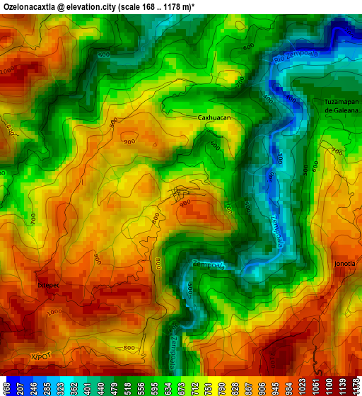
Below is the Elevation map of Ozelonacaxtla, which displays elevation range with different colors. Scale of the first map is from 168 to 1178 m (551 to 3865 ft) with average elevation of 719.1 meters (=2359 ft) [note 1]
These maps also provides idea of topography and contour of this city, they are displayed at different zoom levels. More info about maps, scale and edge coordinates you can find below images.
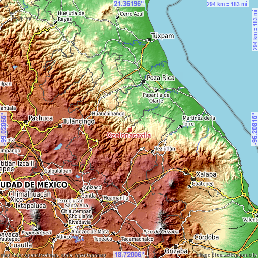
| \ | Map #1 | Topo.Map |
| Scale [m] | 168..1178 m | × |
| Scale [ft] | 551..3865 ft | × |
| Average | 719.1 m = 2359 ft | × |
| Width | 9.18 km = 5.7 mi | 293.8 km = 182.6 mi |
| Height | 9.18 km = 5.7 mi | 293.8 km = 182.6 mi |
| ↑Max Latitude | 20.087847° | 21.36196° |
| Latitude at center | 20.04657° | 20.04657° |
| ↓Min Latitude | 20.005282° | 18.72006° |
| ← Min Longitude | -97.658345° | -99.02065° |
| Longitude center | -97.6144° | -97.6144° |
| →Max Longitude | -97.570455° | -96.20815° |
Nearby cities:
Cities around Ozelonacaxtla sort by population:
• Caxhuacán elevation 700 m
2 km,  22°
22°
• Ixtepec 1059 m
4.1 km,  233°
233°
• Tuxtla 908 m
6.7 km,  219°
219°
• Leacaman 787 m
6.5 km,  332°
332°
• Zozocolco de Guerrero 263 m
7.9 km,  36°
36°
• Huehuetla 545 m
6.7 km,  350°
350°
• Tuzamapan 540 m
4.6 km,  62°
62°
• Atlequizayan 809 m
4 km,  195°
195°
• Lipuntahuaca 465 m
5.2 km,  341°
341°
• Ignacio Allende (Concepción) 880 m
4.5 km,  207°
207°
• Jonotla 1011 m
4.5 km,  113°
113°
• Zoquiopan 1048 m
4.6 km,  155°
155°
Multilingual:
 En español:
Ozelonacaxtla elevación 856 m.
 En France:
Ozelonacaxtla élévation 856 m.
 Auf Deutsch:
Ozelonacaxtla höhe über dem Meeresspiegel ist 856 m.

Sources and notes:
- [note 1] Map square and city borders are not equal. Map elevation data is calculated only from area inside that square.
- [src 1] Elevation data from geonames database provided with same terms of usage.
- [src 2] The elevation map of Ozelonacaxtla is generated using elevation data from NASA's 3 arcsec (90m) resolution SRTM data.
- [src 3] Base (background) map © OpenStreetMap contributors tiles are generated by Geofabrik and OpenTopoMap.
Copyright & License:
This Ozelonacaxtla Elevation Map is licensed under CC BY-SA. You may reuse any part from this page, if you give a proper credit by linking to this URL:
 More info on terms of use page.