Cuauhtamazaco elevation
Cuauhtamazaco (Puebla, Cuetzalan del Progreso), Mexico elevation is 748 meters and Cuauhtamazaco elevation in feet is 2454 ft above sea level [src 1]. Cuauhtamazaco is a populated place (feature code) with elevation that is 566 meters (1857 ft) smaller than average city elevation in Mexico.
Below is the Elevation map of Cuauhtamazaco, which displays elevation range with different colors. Scale of the first map is from 153 to 1453 m (502 to 4767 ft) with average elevation of 789.9 meters (=2592 ft) [note 1]
These maps also provides idea of topography and contour of this city, they are displayed at different zoom levels. More info about maps, scale and edge coordinates you can find below images.
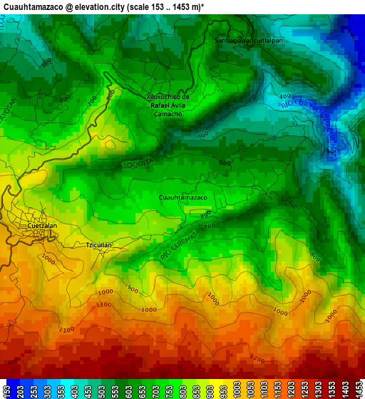
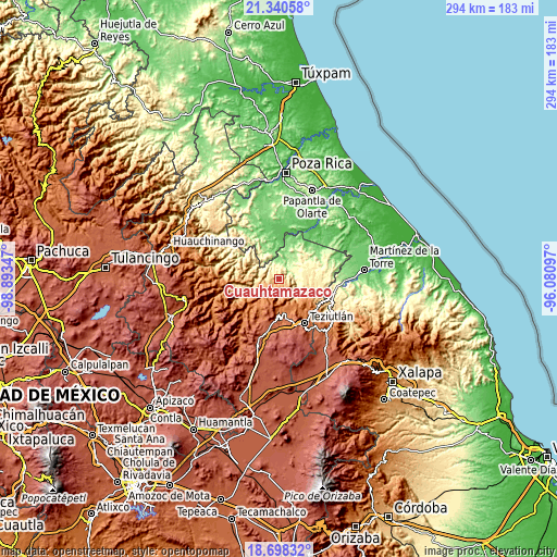
| \ | Map #1 | Topo.Map |
| Scale [m] | 153..1453 m | × |
| Scale [ft] | 502..4767 ft | × |
| Average | 789.9 m = 2592 ft | × |
| Width | 9.18 km = 5.7 mi | 293.8 km = 182.6 mi |
| Height | 9.18 km = 5.7 mi | 293.8 km = 182.6 mi |
| ↑Max Latitude | 20.066283° | 21.34058° |
| Latitude at center | 20.025° | 20.025° |
| ↓Min Latitude | 19.983706° | 18.69832° |
| ← Min Longitude | -97.531165° | -98.89347° |
| Longitude center | -97.48722° | -97.48722° |
| →Max Longitude | -97.443275° | -96.08097° |
Nearby cities:
Cities around Cuauhtamazaco sort by population:
• Ciudad de Cuetzalan elevation 960 m
3.6 km,  258°
258°
• Cuetzalan 979 m
3.8 km, 257°
• Tzinacapan 871 m
5.6 km,  275°
275°
• Ayotoxco de Guerrero 303 m
11.3 km,  45°
45°
• Tuzamapan 540 m
10.2 km,  296°
296°
• Mazatepec 645 m
7.2 km,  97°
97°
• Buena Vista 127 m
11.9 km,  17°
17°
• Tepetitán Reyeshogpan de Hidalgo 354 m
6.6 km,  354°
354°
• Xiloxochico de Rafael Ávila Camacho 742 m
2.3 km, 350°
• Jonotla 1011 m
9.2 km,  273°
273°
• Santiago Yancuictlalpan 611 m
4.3 km, 21°
• Zoquiopan 1048 m
11.5 km, 261°
Multilingual:
 En español:
Cuauhtamazaco elevación 748 m.
 En France:
Cuauhtamazaco élévation 748 m.
 Auf Deutsch:
Cuauhtamazaco höhe über dem Meeresspiegel ist 748 m.

Sources and notes:
- [note 1] Map square and city borders are not equal. Map elevation data is calculated only from area inside that square.
- [src 1] Elevation data from geonames database provided with same terms of usage.
- [src 2] The elevation map of Cuauhtamazaco is generated using elevation data from NASA's 3 arcsec (90m) resolution SRTM data.
- [src 3] Base (background) map © OpenStreetMap contributors tiles are generated by Geofabrik and OpenTopoMap.
Copyright & License:
This Cuauhtamazaco Elevation Map is licensed under CC BY-SA. You may reuse any part from this page, if you give a proper credit by linking to this URL:
 More info on terms of use page.