El Ocotito elevation
El Ocotito (Guerrero, Chilpancingo de los Bravo), Mexico elevation is 714 meters and El Ocotito elevation in feet is 2343 ft above sea level [src 1]. El Ocotito is a populated place (feature code) with elevation that is 600 meters (1969 ft) smaller than average city elevation in Mexico.
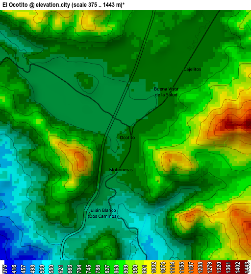
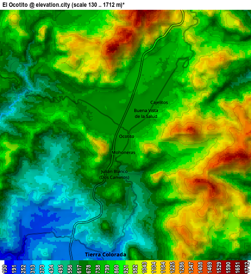
Below is the Elevation map of El Ocotito, which displays elevation range with different colors. Scale of the first map is from 375 to 1443 m (1230 to 4734 ft) with average elevation of 774.3 meters (=2540 ft) [note 1]
These maps also provides idea of topography and contour of this city, they are displayed at different zoom levels. More info about maps, scale and edge coordinates you can find below images.
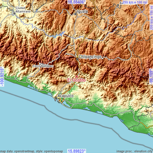
| \ | Map #1 | Map #2 | Topo.Map |
| Scale [m] | 375..1443 m | 130..1712 m | × |
| Scale [ft] | 1230..4734 ft | 427..5617 ft | × |
| Average | 774.3 m = 2540 ft | 790.4 m = 2593 ft | × |
| Width | 9.33 km = 5.8 mi | 18.67 km = 11.6 mi | 298.6 km = 185.5 mi |
| Height | 9.33 km = 5.8 mi | 18.67 km = 11.6 mi | 298.7 km = 185.6 mi |
| ↑Max Latitude | 17.287995° | 17.32995° | 18.58406° |
| Latitude at center | 17.24603° | 17.24603° | 17.24603° |
| ↓Min Latitude | 17.204056° | 17.162072° | 15.89823° |
| ← Min Longitude | -99.559195° | -99.603141° | -100.9215° |
| Longitude center | -99.51525° | -99.51525° | -99.51525° |
| →Max Longitude | -99.471305° | -99.427359° | -98.109° |
Nearby cities:
Cities around El Ocotito sort by population:
• Tierra Colorada elevation 287 m
9 km,  188°
188°
• Mazatlán 1282 m
21.8 km,  14°
14°
• Palo Blanco 1175 m
18.3 km,  16°
16°
• Buena Vista de la Salud 708 m
2.2 km,  40°
40°
• Julián Blanco (Dos Caminos) 640 m
3.2 km,  198°
198°
• Mohoneras 712 m
1.2 km,  184°
184°
• Coacoyulillo 469 m
17.3 km,  304°
304°
• La Palma 232 m
18.3 km, 178°
• Cajelitos 718 m
3.4 km, 44°
• Acahuizotla 831 m
13.7 km, 21°
• El Fresno 1957 m
21.9 km,  339°
339°
• Pueblo Madero (El Playón) 410 m
21.4 km,  231°
231°
Multilingual:
 En español:
El Ocotito elevación 714 m.
 En France:
El Ocotito élévation 714 m.
 Auf Deutsch:
El Ocotito höhe über dem Meeresspiegel ist 714 m.

Sources and notes:
- [note 1] Map square and city borders are not equal. Map elevation data is calculated only from area inside that square.
- [src 1] Elevation data from geonames database provided with same terms of usage.
- [src 2] The elevation map of El Ocotito is generated using elevation data from NASA's 3 arcsec (90m) resolution SRTM data.
- [src 3] Base (background) map © OpenStreetMap contributors tiles are generated by Geofabrik and OpenTopoMap.
Copyright & License:
This El Ocotito Elevation Map is licensed under CC BY-SA. You may reuse any part from this page, if you give a proper credit by linking to this URL:
 More info on terms of use page.