La Palma elevation
La Palma (Guerrero, Juan R. Escudero), Mexico elevation is 232 meters and La Palma elevation in feet is 761 ft above sea level [src 1]. La Palma is a populated place (feature code) with elevation that is 1082 meters (3550 ft) smaller than average city elevation in Mexico.
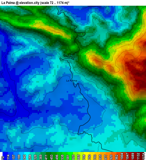
Below is the Elevation map of La Palma, which displays elevation range with different colors. Scale of the first map is from 72 to 1174 m (236 to 3852 ft) with average elevation of 340.7 meters (=1118 ft) [note 1]
These maps also provides idea of topography and contour of this city, they are displayed at different zoom levels. More info about maps, scale and edge coordinates you can find below images.
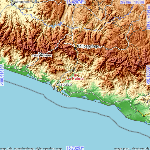
| \ | Map #1 | Topo.Map |
| Scale [m] | 72..1174 m | × |
| Scale [ft] | 236..3852 ft | × |
| Average | 340.7 m = 1118 ft | × |
| Width | 9.34 km = 5.8 mi | 298.9 km = 185.7 mi |
| Height | 9.34 km = 5.8 mi | 298.9 km = 185.7 mi |
| ↑Max Latitude | 17.123482° | 18.42074° |
| Latitude at center | 17.08148° | 17.08148° |
| ↓Min Latitude | 17.039468° | 15.73253° |
| ← Min Longitude | -99.553885° | -100.91619° |
| Longitude center | -99.50994° | -99.50994° |
| →Max Longitude | -99.465995° | -98.10369° |
Nearby cities:
Cities around La Palma sort by population:
• Tierra Colorada elevation 287 m
9.6 km,  348°
348°
• El Ocotito 714 m
18.3 km,  358°
358°
• Las Mesas 429 m
9.9 km,  145°
145°
• Julián Blanco (Dos Caminos) 640 m
15.4 km, 354°
• Dos Arroyos 224 m
16.3 km,  245°
245°
• Mohoneras 712 m
17.1 km, 357°
• El Limón 611 m
17 km,  124°
124°
• Las Cruces 426 m
13.9 km, 150°
• Pochotillo 363 m
11.1 km,  127°
127°
• Llano Grande 325 m
17.7 km, 152°
• El Terrero 348 m
17.8 km,  74°
74°
• Pueblo Madero (El Playón) 410 m
18 km,  286°
286°
Multilingual:
 En español:
La Palma elevación 232 m.
 En France:
La Palma élévation 232 m.
 Auf Deutsch:
La Palma höhe über dem Meeresspiegel ist 232 m.

Sources and notes:
- [note 1] Map square and city borders are not equal. Map elevation data is calculated only from area inside that square.
- [src 1] Elevation data from geonames database provided with same terms of usage.
- [src 2] The elevation map of La Palma is generated using elevation data from NASA's 3 arcsec (90m) resolution SRTM data.
- [src 3] Base (background) map © OpenStreetMap contributors tiles are generated by Geofabrik and OpenTopoMap.
Copyright & License:
This La Palma Elevation Map is licensed under CC BY-SA. You may reuse any part from this page, if you give a proper credit by linking to this URL:
 More info on terms of use page.