Mazatlán elevation
Mazatlán (Guerrero, Chilpancingo de los Bravo), Mexico elevation is 1282 meters and Mazatlán elevation in feet is 4206 ft above sea level [src 1]. Mazatlán is a populated place (feature code) with elevation that is 32 meters (105 ft) smaller than average city elevation in Mexico.
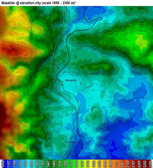
Below is the Elevation map of Mazatlán, which displays elevation range with different colors. Scale of the first map is from 1059 to 2300 m (3474 to 7546 ft) with average elevation of 1446.6 meters (=4746 ft) [note 1]
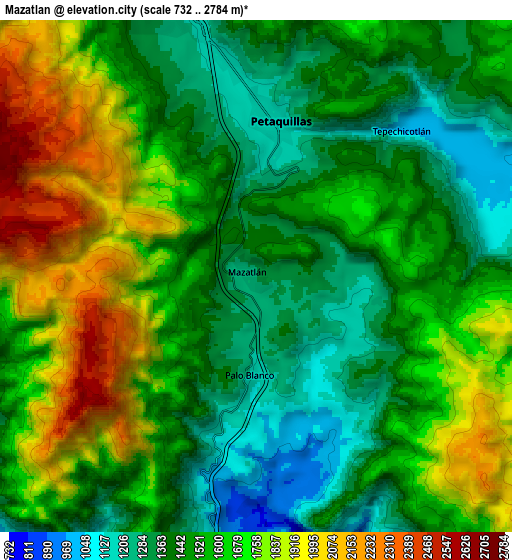
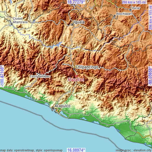
These maps also provides idea of topography and contour of this city, they are displayed at different zoom levels. More info about maps, scale and edge coordinates you can find below images.
| \ | Map #1 | Map #2 | Topo.Map |
| Scale [m] | 1059..2300 m | 732..2784 m | × |
| Scale [ft] | 3474..7546 ft | 2402..9134 ft | × |
| Average | 1446.6 m = 4746 ft | 1572 m = 5157 ft | × |
| Width | 9.32 km = 5.8 mi | 18.65 km = 11.6 mi | 298.3 km = 185.4 mi |
| Height | 9.32 km = 5.8 mi | 18.65 km = 11.6 mi | 298.3 km = 185.4 mi |
| ↑Max Latitude | 17.478121° | 17.520033° | 18.77279° |
| Latitude at center | 17.4362° | 17.4362° | 17.4362° |
| ↓Min Latitude | 17.394269° | 17.352329° | 16.08974° |
| ← Min Longitude | -99.508775° | -99.552721° | -100.87108° |
| Longitude center | -99.46483° | -99.46483° | -99.46483° |
| →Max Longitude | -99.420885° | -99.376939° | -98.05858° |
Nearby cities:
Cities around Mazatlán sort by population:
• Chilpancingo elevation 1242 m
13.4 km,  341°
341°
• Tixtla de Guerrero 1354 m
16.2 km,  25°
25°
• Petaquillas 1153 m
5.6 km,  9°
9°
• Mochitlán 1010 m
10.8 km,  68°
68°
• Palo Blanco 1175 m
3.6 km,  182°
182°
• Buena Vista de la Salud 708 m
19.9 km,  191°
191°
• Tepechicotlán 1042 m
7.4 km,  45°
45°
• Cajelitos 718 m
19 km, 189°
• San Martín 1017 m
18.3 km,  80°
80°
• El Durazno 1917 m
21.1 km,  61°
61°
• Acahuizotla 831 m
8.4 km, 181°
• El Fresno 1957 m
12.9 km,  267°
267°
Multilingual:
 En español:
Mazatlán elevación 1282 m.
 En France:
Mazatlán élévation 1282 m.
 Auf Deutsch:
Mazatlán höhe über dem Meeresspiegel ist 1282 m.

Sources and notes:
- [note 1] Map square and city borders are not equal. Map elevation data is calculated only from area inside that square.
- [src 1] Elevation data from geonames database provided with same terms of usage.
- [src 2] The elevation map of Mazatlán is generated using elevation data from NASA's 3 arcsec (90m) resolution SRTM data.
- [src 3] Base (background) map © OpenStreetMap contributors tiles are generated by Geofabrik and OpenTopoMap.
Copyright & License:
This Mazatlán Elevation Map is licensed under CC BY-SA. You may reuse any part from this page, if you give a proper credit by linking to this URL:
 More info on terms of use page.