Tixtla de Guerrero elevation
Tixtla de Guerrero (Guerrero), Mexico elevation is 1354 meters and Tixtla de Guerrero elevation in feet is 4442 ft above sea level [src 1]. Tixtla de Guerrero is a populated place (feature code) with elevation that is 40 meters (131 ft) bigger than average city elevation in Mexico.
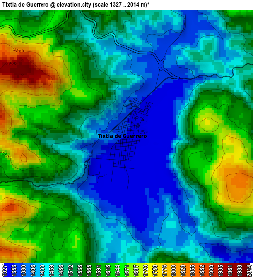
Below is the Elevation map of Tixtla de Guerrero, which displays elevation range with different colors. Scale of the first map is from 1327 to 2014 m (4354 to 6608 ft) with average elevation of 1528.9 meters (=5016 ft) [note 1]
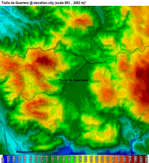
These maps also provides idea of topography and contour of this city, they are displayed at different zoom levels. More info about maps, scale and edge coordinates you can find below images.
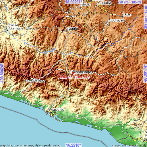
| \ | Map #1 | Map #2 | Topo.Map |
| Scale [m] | 1327..2014 m | 983..2063 m | × |
| Scale [ft] | 4354..6608 ft | 3225..6768 ft | × |
| Average | 1528.9 m = 5016 ft | 1499.8 m = 4921 ft | × |
| Width | 9.32 km = 5.8 mi | 18.63 km = 11.6 mi | 298.1 km = 185.2 mi |
| Height | 9.32 km = 5.8 mi | 18.63 km = 11.6 mi | 298.1 km = 185.2 mi |
| ↑Max Latitude | 17.609211° | 17.651092° | 18.90291° |
| Latitude at center | 17.56732° | 17.56732° | 17.56732° |
| ↓Min Latitude | 17.525419° | 17.483509° | 16.2218° |
| ← Min Longitude | -99.441935° | -99.485881° | -100.80424° |
| Longitude center | -99.39799° | -99.39799° | -99.39799° |
| →Max Longitude | -99.354045° | -99.310099° | -97.99174° |
Nearby cities:
Cities around Tixtla de Guerrero sort by population:
• Chilpancingo elevation 1242 m
11.6 km,  260°
260°
• Petaquillas 1153 m
10.9 km,  214°
214°
• Atliaca 1291 m
9.7 km,  14°
14°
• Mochitlán 1010 m
11 km,  164°
164°
• Acatempa 1287 m
9.1 km,  21°
21°
• Cuonetzingo 1946 m
14.7 km,  107°
107°
• Hueyitlalpan 1660 m
16.2 km,  42°
42°
• Tepechicotlán 1042 m
9.5 km,  191°
191°
• Zoquiapa 1881 m
13.1 km,  101°
101°
• Almolonga 1725 m
13.5 km,  54°
54°
• San Martín 1017 m
16 km,  136°
136°
• El Durazno 1917 m
12.2 km, 110°
Multilingual:
 En español:
Tixtla de Guerrero elevación 1354 m.
 En France:
Tixtla de Guerrero élévation 1354 m.
 Auf Deutsch:
Tixtla de Guerrero höhe über dem Meeresspiegel ist 1354 m.
 На русском:
Тихтла-де-Герреро высота над уровнем моря 1354 м
Sources and notes:
- [note 1] Map square and city borders are not equal. Map elevation data is calculated only from area inside that square.
- [src 1] Elevation data from geonames database provided with same terms of usage.
- [src 2] The elevation map of Tixtla de Guerrero is generated using elevation data from NASA's 3 arcsec (90m) resolution SRTM data.
- [src 3] Base (background) map © OpenStreetMap contributors tiles are generated by Geofabrik and OpenTopoMap.
Copyright & License:
This Tixtla de Guerrero Elevation Map is licensed under CC BY-SA. You may reuse any part from this page, if you give a proper credit by linking to this URL:
 More info on terms of use page.