Huajintepec elevation
Huajintepec (Oaxaca), Mexico elevation is 333 meters and Huajintepec elevation in feet is 1093 ft above sea level [src 1]. Huajintepec is a populated place (feature code) with elevation that is 981 meters (3219 ft) smaller than average city elevation in Mexico.
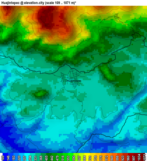
Below is the Elevation map of Huajintepec, which displays elevation range with different colors. Scale of the first map is from 109 to 1071 m (358 to 3514 ft) with average elevation of 401.5 meters (=1317 ft) [note 1]
These maps also provides idea of topography and contour of this city, they are displayed at different zoom levels. More info about maps, scale and edge coordinates you can find below images.
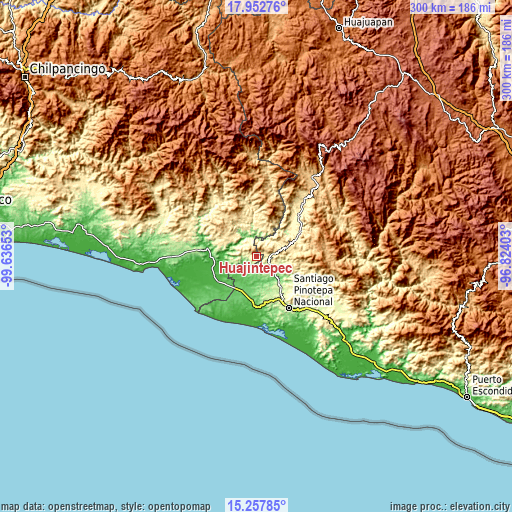
| \ | Map #1 | Topo.Map |
| Scale [m] | 109..1071 m | × |
| Scale [ft] | 358..3514 ft | × |
| Average | 401.5 m = 1317 ft | × |
| Width | 9.36 km = 5.8 mi | 299.6 km = 186.2 mi |
| Height | 9.36 km = 5.8 mi | 299.7 km = 186.2 mi |
| ↑Max Latitude | 16.652137° | 17.95276° |
| Latitude at center | 16.61003° | 16.61003° |
| ↓Min Latitude | 16.567914° | 15.25785° |
| ← Min Longitude | -98.274225° | -99.63653° |
| Longitude center | -98.23028° | -98.23028° |
| →Max Longitude | -98.186335° | -96.82403° |
Nearby cities:
Cities around Huajintepec sort by population:
• San Pedro Amuzgos elevation 509 m
15.5 km,  71°
71°
• Zacoalpan 207 m
16.2 km,  337°
337°
• San Juan Cacahuatepec 424 m
8 km,  85°
85°
• Huixtepec 371 m
9.3 km,  301°
301°
• Guadalupe Victoria 456 m
17 km,  17°
17°
• San Juan Bautista Lo de Soto 74 m
16.6 km,  228°
228°
• Santiago Llano Grande 77 m
14.9 km,  205°
205°
• San Sebastián Ixcapa 244 m
11.6 km,  128°
128°
• La Guadalupe 432 m
9.4 km, 338°
• Los Liros 301 m
14.5 km,  5°
5°
• San Antonio Ocotlán 719 m
8.1 km,  57°
57°
• Camotinchan 200 m
12.6 km,  116°
116°
Multilingual:
 En español:
Huajintepec elevación 333 m.
 En France:
Huajintepec élévation 333 m.
 Auf Deutsch:
Huajintepec höhe über dem Meeresspiegel ist 333 m.

Sources and notes:
- [note 1] Map square and city borders are not equal. Map elevation data is calculated only from area inside that square.
- [src 1] Elevation data from geonames database provided with same terms of usage.
- [src 2] The elevation map of Huajintepec is generated using elevation data from NASA's 3 arcsec (90m) resolution SRTM data.
- [src 3] Base (background) map © OpenStreetMap contributors tiles are generated by Geofabrik and OpenTopoMap.
Copyright & License:
This Huajintepec Elevation Map is licensed under CC BY-SA. You may reuse any part from this page, if you give a proper credit by linking to this URL:
 More info on terms of use page.