Zacoalpan elevation
Zacoalpan (Guerrero, Ometepec), Mexico elevation is 207 meters and Zacoalpan elevation in feet is 679 ft above sea level [src 1]. Zacoalpan is a populated place (feature code) with elevation that is 1107 meters (3632 ft) smaller than average city elevation in Mexico.
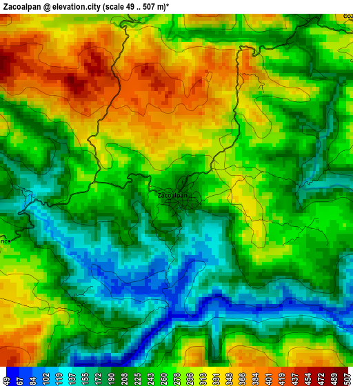
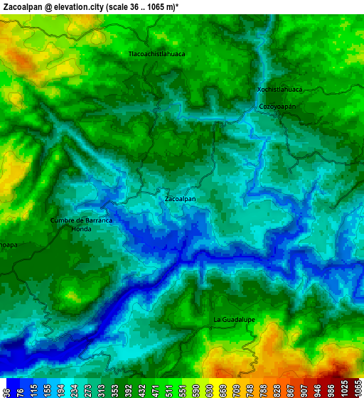
Below is the Elevation map of Zacoalpan, which displays elevation range with different colors. Scale of the first map is from 49 to 507 m (161 to 1663 ft) with average elevation of 254.3 meters (=834 ft) [note 1]
These maps also provides idea of topography and contour of this city, they are displayed at different zoom levels. More info about maps, scale and edge coordinates you can find below images.
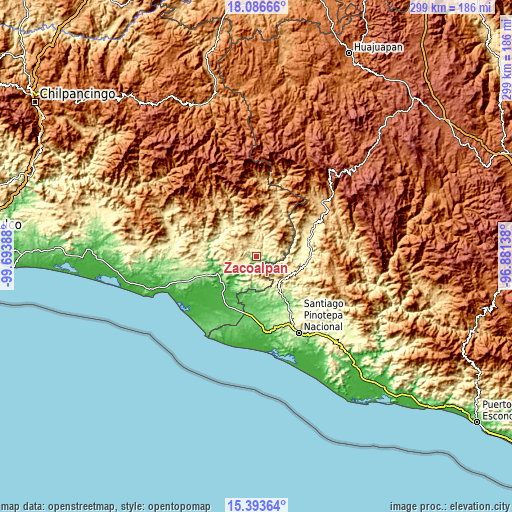
| \ | Map #1 | Map #2 | Topo.Map |
| Scale [m] | 49..507 m | 36..1065 m | × |
| Scale [ft] | 161..1663 ft | 118..3494 ft | × |
| Average | 254.3 m = 834 ft | 361 m = 1184 ft | × |
| Width | 9.36 km = 5.8 mi | 18.72 km = 11.6 mi | 299.4 km = 186 mi |
| Height | 9.36 km = 5.8 mi | 18.72 km = 11.6 mi | 299.5 km = 186.1 mi |
| ↑Max Latitude | 16.786987° | 16.829055° | 18.08666° |
| Latitude at center | 16.74491° | 16.74491° | 16.74491° |
| ↓Min Latitude | 16.702823° | 16.660728° | 15.39364° |
| ← Min Longitude | -98.331575° | -98.375521° | -99.69388° |
| Longitude center | -98.28763° | -98.28763° | -98.28763° |
| →Max Longitude | -98.243685° | -98.199739° | -96.88138° |
Nearby cities:
Cities around Zacoalpan sort by population:
• Ometepec elevation 334 m
14.2 km,  244°
244°
• Tlacoachistlahuaca 414 m
7.4 km,  349°
349°
• Cochoapa 397 m
9.3 km,  254°
254°
• Xochistlahuaca 375 m
7.4 km,  42°
42°
• Huixtepec 371 m
10.3 km,  190°
190°
• Acatepec 628 m
14.9 km,  266°
266°
• Guadalupe Victoria 456 m
11.4 km,  83°
83°
• Santa María 575 m
11.4 km,  284°
284°
• Colonia Renacimiento 478 m
11.4 km, 79°
• Cumbre de Barranca Honda 320 m
5.4 km, 254°
• La Guadalupe 432 m
6.8 km,  156°
156°
• Los Liros 301 m
7.5 km,  94°
94°
Multilingual:
 En español:
Zacoalpan elevación 207 m.
 En France:
Zacoalpan élévation 207 m.
 Auf Deutsch:
Zacoalpan höhe über dem Meeresspiegel ist 207 m.

Sources and notes:
- [note 1] Map square and city borders are not equal. Map elevation data is calculated only from area inside that square.
- [src 1] Elevation data from geonames database provided with same terms of usage.
- [src 2] The elevation map of Zacoalpan is generated using elevation data from NASA's 3 arcsec (90m) resolution SRTM data.
- [src 3] Base (background) map © OpenStreetMap contributors tiles are generated by Geofabrik and OpenTopoMap.
Copyright & License:
This Zacoalpan Elevation Map is licensed under CC BY-SA. You may reuse any part from this page, if you give a proper credit by linking to this URL:
 More info on terms of use page.