Huajintlán elevation
Huajintlán (Morelos, Amacuzac), Mexico elevation is 930 meters and Huajintlán elevation in feet is 3051 ft above sea level [src 1]. Huajintlán is a populated place (feature code) with elevation that is 384 meters (1260 ft) smaller than average city elevation in Mexico.
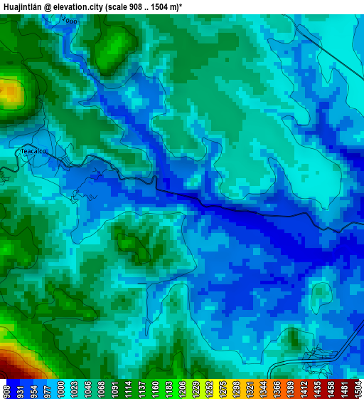
Below is the Elevation map of Huajintlán, which displays elevation range with different colors. Scale of the first map is from 908 to 1504 m (2979 to 4934 ft) with average elevation of 1025.5 meters (=3365 ft) [note 1]
These maps also provides idea of topography and contour of this city, they are displayed at different zoom levels. More info about maps, scale and edge coordinates you can find below images.
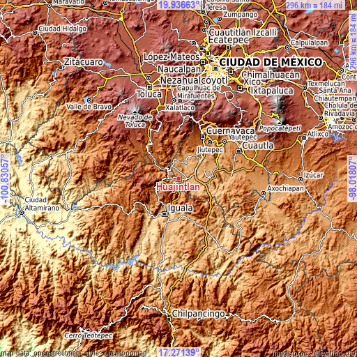
| \ | Map #1 | Topo.Map |
| Scale [m] | 908..1504 m | × |
| Scale [ft] | 2979..4934 ft | × |
| Average | 1025.5 m = 3365 ft | × |
| Width | 9.26 km = 5.8 mi | 296.3 km = 184.1 mi |
| Height | 9.26 km = 5.8 mi | 296.4 km = 184.2 mi |
| ↑Max Latitude | 18.650873° | 19.93663° |
| Latitude at center | 18.60923° | 18.60923° |
| ↓Min Latitude | 18.567577° | 17.27139° |
| ← Min Longitude | -99.468265° | -100.83057° |
| Longitude center | -99.42432° | -99.42432° |
| →Max Longitude | -99.380375° | -98.01807° |
Nearby cities:
Cities around Huajintlán sort by population:
• Puente de Ixtla elevation 911 m
11.2 km,  86°
86°
• La Joya 1010 m
7.8 km,  325°
325°
• Amacuzac 922 m
5.9 km,  101°
101°
• Acuitlapan 1579 m
12.5 km,  266°
266°
• San Gabriel las Palmas 928 m
8.2 km, 86°
• Cuauchichinola 945 m
7.9 km,  40°
40°
• Casahuatlán 985 m
5.4 km,  138°
138°
• Axixintla 1222 m
9.9 km, 265°
• Santa Fe Tepetlapa 1056 m
6.7 km,  180°
180°
• Palmillas 1112 m
9.7 km, 180°
• Coahuixtla 929 m
6.9 km,  124°
124°
• Michapa 1202 m
11.9 km, 330°
Multilingual:
 En español:
Huajintlán elevación 930 m.
 En France:
Huajintlán élévation 930 m.
 Auf Deutsch:
Huajintlán höhe über dem Meeresspiegel ist 930 m.

Sources and notes:
- [note 1] Map square and city borders are not equal. Map elevation data is calculated only from area inside that square.
- [src 1] Elevation data from geonames database provided with same terms of usage.
- [src 2] The elevation map of Huajintlán is generated using elevation data from NASA's 3 arcsec (90m) resolution SRTM data.
- [src 3] Base (background) map © OpenStreetMap contributors tiles are generated by Geofabrik and OpenTopoMap.
Copyright & License:
This Huajintlán Elevation Map is licensed under CC BY-SA. You may reuse any part from this page, if you give a proper credit by linking to this URL:
 More info on terms of use page.