Puente de Ixtla elevation
Puente de Ixtla (Morelos), Mexico elevation is 911 meters and Puente de Ixtla elevation in feet is 2989 ft above sea level [src 1]. Puente de Ixtla is a populated place (feature code) with elevation that is 403 meters (1322 ft) smaller than average city elevation in Mexico.
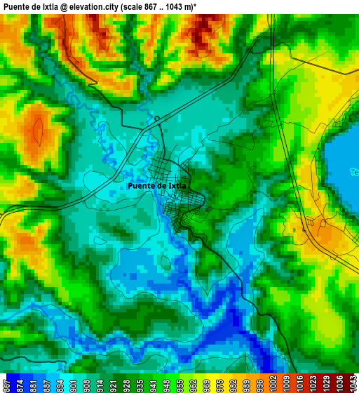
Below is the Elevation map of Puente de Ixtla, which displays elevation range with different colors. Scale of the first map is from 867 to 1043 m (2844 to 3422 ft) with average elevation of 931.3 meters (=3055 ft) [note 1]
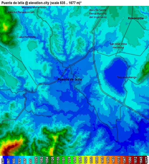
These maps also provides idea of topography and contour of this city, they are displayed at different zoom levels. More info about maps, scale and edge coordinates you can find below images.
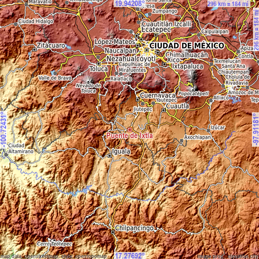
| \ | Map #1 | Map #2 | Topo.Map |
| Scale [m] | 867..1043 m | 835..1677 m | × |
| Scale [ft] | 2844..3422 ft | 2740..5502 ft | × |
| Average | 931.3 m = 3055 ft | 975.1 m = 3199 ft | × |
| Width | 9.26 km = 5.8 mi | 18.52 km = 11.5 mi | 296.3 km = 184.1 mi |
| Height | 9.26 km = 5.8 mi | 18.52 km = 11.5 mi | 296.4 km = 184.2 mi |
| ↑Max Latitude | 18.656361° | 18.697992° | 19.94208° |
| Latitude at center | 18.61472° | 18.61472° | 18.61472° |
| ↓Min Latitude | 18.573069° | 18.531407° | 17.27692° |
| ← Min Longitude | -99.362005° | -99.405951° | -100.72431° |
| Longitude center | -99.31806° | -99.31806° | -99.31806° |
| →Max Longitude | -99.274115° | -99.230169° | -97.91181° |
Nearby cities:
Cities around Puente de Ixtla sort by population:
• Tehuixtla elevation 894 m
7.9 km,  141°
141°
• Amacuzac 922 m
5.7 km,  251°
251°
• San José Vista Hermosa 1002 m
7 km,  51°
51°
• Unidad Habitacional José María Morelos y Pavón 961 m
10.5 km,  86°
86°
• Tequesquitengo 932 m
6.1 km, 93°
• San Gabriel las Palmas 928 m
3 km,  268°
268°
• Cuauchichinola 945 m
8.2 km,  311°
311°
• Casahuatlán 985 m
9 km,  238°
238°
• El Estudiante 871 m
4.7 km,  151°
151°
• Ahuehuetzingo 975 m
7.4 km,  8°
8°
• Jicarero 959 m
10 km, 89°
• Coahuixtla 929 m
7.1 km,  230°
230°
Multilingual:
 En español:
Puente de Ixtla elevación 911 m.
 En France:
Puente de Ixtla élévation 911 m.
 Auf Deutsch:
Puente de Ixtla höhe über dem Meeresspiegel ist 911 m.

Sources and notes:
- [note 1] Map square and city borders are not equal. Map elevation data is calculated only from area inside that square.
- [src 1] Elevation data from geonames database provided with same terms of usage.
- [src 2] The elevation map of Puente de Ixtla is generated using elevation data from NASA's 3 arcsec (90m) resolution SRTM data.
- [src 3] Base (background) map © OpenStreetMap contributors tiles are generated by Geofabrik and OpenTopoMap.
Copyright & License:
This Puente de Ixtla Elevation Map is licensed under CC BY-SA. You may reuse any part from this page, if you give a proper credit by linking to this URL:
 More info on terms of use page.