Joaquín Miguel Gutiérrez elevation
Joaquín Miguel Gutiérrez (Chiapas, Frontera Comalapa), Mexico elevation is 605 meters and Joaquín Miguel Gutiérrez elevation in feet is 1985 ft above sea level [src 1]. Joaquín Miguel Gutiérrez is a populated place (feature code) with elevation that is 709 meters (2326 ft) smaller than average city elevation in Mexico.
Below is the Elevation map of Joaquín Miguel Gutiérrez, which displays elevation range with different colors. Scale of the first map is from 570 to 743 m (1870 to 2438 ft) with average elevation of 610.6 meters (=2003 ft) [note 1]
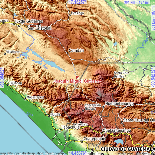
These maps also provides idea of topography and contour of this city, they are displayed at different zoom levels. More info about maps, scale and edge coordinates you can find below images.
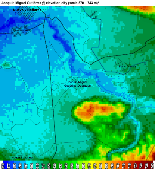
| \ | Map #1 | Topo.Map |
| Scale [m] | 570..743 m | × |
| Scale [ft] | 1870..2438 ft | × |
| Average | 610.6 m = 2003 ft | × |
| Width | 9.4 km = 5.8 mi | 300.9 km = 187 mi |
| Height | 9.4 km = 5.8 mi | 300.9 km = 187 mi |
| ↑Max Latitude | 15.856468° | 17.16257° |
| Latitude at center | 15.81419° | 15.81419° |
| ↓Min Latitude | 15.771904° | 14.45676° |
| ← Min Longitude | -91.992515° | -93.35482° |
| Longitude center | -91.94857° | -91.94857° |
| →Max Longitude | -91.904625° | -90.54232° |
Nearby cities:
Cities around Joaquín Miguel Gutiérrez sort by population:
• Paso Hondo elevation 695 m
16.3 km,  207°
207°
• Ciudad Cuauhtémoc 707 m
17.5 km,  199°
199°
• Rodulfo Figueroa 751 m
12.7 km,  22°
22°
• Verapaz 702 m
16.7 km,  226°
226°
• Doctor Rodulfo Figueroa (Tierra Blanca) 588 m
12.8 km,  288°
288°
• Las Delicias 889 m
19.5 km,  27°
27°
• La Gloria 799 m
16.7 km,  353°
353°
• Sabinalito 679 m
13.1 km, 197°
• San Caralampio 584 m
9.5 km,  280°
280°
• Monte Redondo 773 m
21.1 km, 211°
• Nueva Libertad (El Colorado) 594 m
15.1 km,  308°
308°
• Sinaloa 575 m
21.2 km, 294°
Multilingual:
 En español:
Joaquín Miguel Gutiérrez, Quespala elevación 605 m.
 En France:
Joaquín Miguel Gutiérrez élévation 605 m.
 Auf Deutsch:
Joaquín Miguel Gutiérrez höhe über dem Meeresspiegel ist 605 m.
 На русском:
Joaquín Miguel Gutiérrez высота над уровнем моря 605 м
Sources and notes:
- [note 1] Map square and city borders are not equal. Map elevation data is calculated only from area inside that square.
- [src 1] Elevation data from geonames database provided with same terms of usage.
- [src 2] The elevation map of Joaquín Miguel Gutiérrez is generated using elevation data from NASA's 3 arcsec (90m) resolution SRTM data.
- [src 3] Base (background) map © OpenStreetMap contributors tiles are generated by Geofabrik and OpenTopoMap.
Copyright & License:
This Joaquín Miguel Gutiérrez Elevation Map is licensed under CC BY-SA. You may reuse any part from this page, if you give a proper credit by linking to this URL:
 More info on terms of use page.