Sinaloa elevation
Sinaloa (Chiapas, Frontera Comalapa), Mexico elevation is 575 meters and Sinaloa elevation in feet is 1886 ft above sea level [src 1]. Sinaloa is a populated place (feature code) with elevation that is 739 meters (2425 ft) smaller than average city elevation in Mexico.
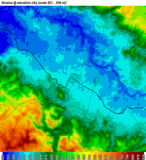
Below is the Elevation map of Sinaloa, which displays elevation range with different colors. Scale of the first map is from 521 to 830 m (1709 to 2723 ft) with average elevation of 607.1 meters (=1992 ft) [note 1]
These maps also provides idea of topography and contour of this city, they are displayed at different zoom levels. More info about maps, scale and edge coordinates you can find below images.
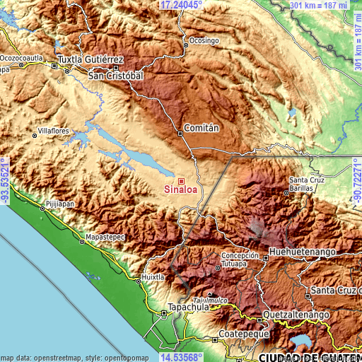
| \ | Map #1 | Topo.Map |
| Scale [m] | 521..830 m | × |
| Scale [ft] | 1709..2723 ft | × |
| Average | 607.1 m = 1992 ft | × |
| Width | 9.4 km = 5.8 mi | 300.7 km = 186.8 mi |
| Height | 9.4 km = 5.8 mi | 300.8 km = 186.9 mi |
| ↑Max Latitude | 15.934871° | 17.24045° |
| Latitude at center | 15.89261° | 15.89261° |
| ↓Min Latitude | 15.85034° | 14.53568° |
| ← Min Longitude | -92.172905° | -93.53521° |
| Longitude center | -92.12896° | -92.12896° |
| →Max Longitude | -92.085015° | -90.72271° |
Nearby cities:
Cities around Sinaloa sort by population:
• Pablo L. Sidar elevation 622 m
17.5 km,  246°
246°
• Verapaz 702 m
21.4 km,  160°
160°
• Doctor Rodulfo Figueroa (Tierra Blanca) 588 m
8.5 km,  123°
123°
• Nueva Independencia 706 m
14.9 km,  214°
214°
• La Gloria 799 m
19.2 km,  65°
65°
• Joaquín Miguel Gutiérrez 605 m
21.2 km,  114°
114°
• San Caralampio 584 m
12.2 km,  125°
125°
• Nueva Libertad 711 m
17 km, 207°
• Nueva Libertad (El Colorado) 594 m
7.5 km,  84°
84°
• Chihuahua 893 m
22.6 km,  47°
47°
• Nueva América 599 m
19.2 km,  280°
280°
• Guadalupe Grijalva 634 m
21.9 km,  189°
189°
Multilingual:
 En español:
Sinaloa elevación 575 m.
 En France:
Sinaloa élévation 575 m.


Sources and notes:
- [note 1] Map square and city borders are not equal. Map elevation data is calculated only from area inside that square.
- [src 1] Elevation data from geonames database provided with same terms of usage.
- [src 2] The elevation map of Sinaloa is generated using elevation data from NASA's 3 arcsec (90m) resolution SRTM data.
- [src 3] Base (background) map © OpenStreetMap contributors tiles are generated by Geofabrik and OpenTopoMap.
Copyright & License:
This Sinaloa Elevation Map is licensed under CC BY-SA. You may reuse any part from this page, if you give a proper credit by linking to this URL:
 More info on terms of use page.