Chihuahua elevation
Chihuahua (Chiapas, La Trinitaria), Mexico elevation is 893 meters and Chihuahua elevation in feet is 2930 ft above sea level [src 1]. Chihuahua is a populated place (feature code) with elevation that is 421 meters (1381 ft) smaller than average city elevation in Mexico.
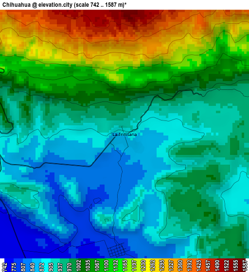
Below is the Elevation map of Chihuahua, which displays elevation range with different colors. Scale of the first map is from 742 to 1587 m (2434 to 5207 ft) with average elevation of 1003.6 meters (=3293 ft) [note 1]
These maps also provides idea of topography and contour of this city, they are displayed at different zoom levels. More info about maps, scale and edge coordinates you can find below images.
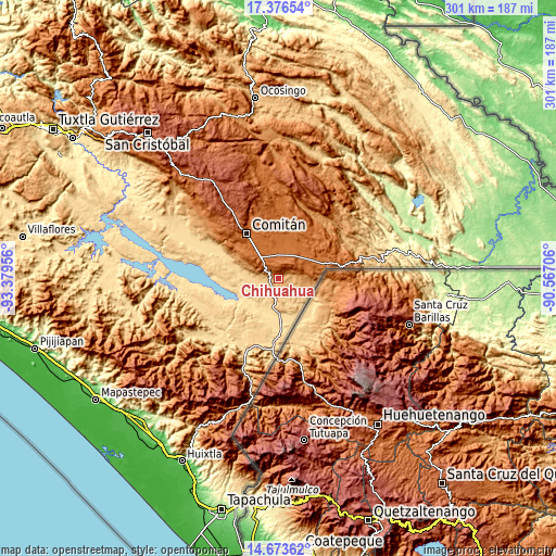
| \ | Map #1 | Topo.Map |
| Scale [m] | 742..1587 m | × |
| Scale [ft] | 2434..5207 ft | × |
| Average | 1003.6 m = 3293 ft | × |
| Width | 9.39 km = 5.8 mi | 300.5 km = 186.7 mi |
| Height | 9.39 km = 5.8 mi | 300.6 km = 186.8 mi |
| ↑Max Latitude | 16.071892° | 17.37654° |
| Latitude at center | 16.02966° | 16.02966° |
| ↓Min Latitude | 15.987419° | 14.67362° |
| ← Min Longitude | -92.017255° | -93.37956° |
| Longitude center | -91.97331° | -91.97331° |
| →Max Longitude | -91.929365° | -90.56706° |
Nearby cities:
Cities around Chihuahua sort by population:
• La Trinitaria elevation 1564 m
13 km,  319°
319°
• José María Morelos 1294 m
15.2 km,  84°
84°
• La Esperanza 1519 m
17.6 km,  39°
39°
• Rodulfo Figueroa 751 m
14.3 km,  148°
148°
• Las Delicias 889 m
13.6 km,  119°
119°
• La Gloria 799 m
7.4 km,  173°
173°
• Álvaro Obregón 1453 m
15.7 km,  62°
62°
• El Progreso 1543 m
15.4 km,  51°
51°
• Santa Rita 1573 m
11.3 km,  359°
359°
• Emiliano Zapata 1511 m
16.9 km,  1°
1°
• Nueva Libertad (El Colorado) 594 m
17.2 km,  212°
212°
• Unión Juárez 1566 m
11.8 km,  21°
21°
Multilingual:
 En español:
Chihuahua elevación 893 m.
 En France:
Chihuahua élévation 893 m.
 Auf Deutsch:
Chihuahua höhe über dem Meeresspiegel ist 893 m.

Sources and notes:
- [note 1] Map square and city borders are not equal. Map elevation data is calculated only from area inside that square.
- [src 1] Elevation data from geonames database provided with same terms of usage.
- [src 2] The elevation map of Chihuahua is generated using elevation data from NASA's 3 arcsec (90m) resolution SRTM data.
- [src 3] Base (background) map © OpenStreetMap contributors tiles are generated by Geofabrik and OpenTopoMap.
Copyright & License:
This Chihuahua Elevation Map is licensed under CC BY-SA. You may reuse any part from this page, if you give a proper credit by linking to this URL:
 More info on terms of use page.