La Trinitaria elevation
La Trinitaria (Chiapas), Mexico elevation is 1564 meters and La Trinitaria elevation in feet is 5131 ft above sea level [src 1]. La Trinitaria is a seat of a second-order administrative division (feature code) with elevation that is 250 meters (820 ft) bigger than average city elevation in Mexico.
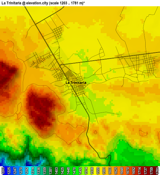
Below is the Elevation map of La Trinitaria, which displays elevation range with different colors. Scale of the first map is from 1203 to 1781 m (3947 to 5843 ft) with average elevation of 1560.4 meters (=5119 ft) [note 1]
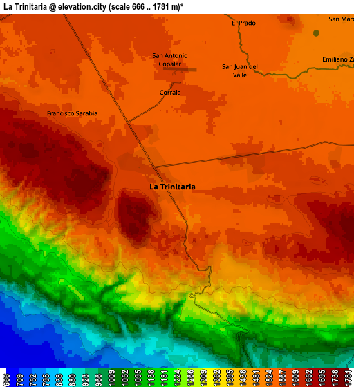
These maps also provides idea of topography and contour of this city, they are displayed at different zoom levels. More info about maps, scale and edge coordinates you can find below images.
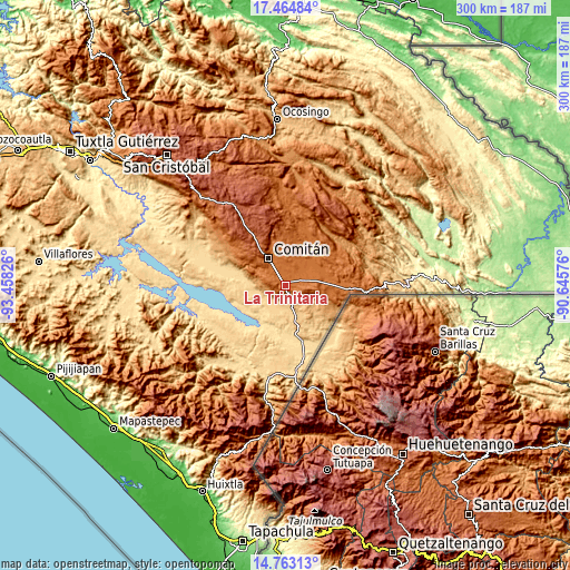
| \ | Map #1 | Map #2 | Topo.Map |
| Scale [m] | 1203..1781 m | 666..1781 m | × |
| Scale [ft] | 3947..5843 ft | 2185..5843 ft | × |
| Average | 1560.4 m = 5119 ft | 1433.4 m = 4703 ft | × |
| Width | 9.39 km = 5.8 mi | 18.78 km = 11.7 mi | 300.4 km = 186.7 mi |
| Height | 9.39 km = 5.8 mi | 18.78 km = 11.7 mi | 300.4 km = 186.7 mi |
| ↑Max Latitude | 16.160803° | 16.203008° | 17.46484° |
| Latitude at center | 16.11859° | 16.11859° | 16.11859° |
| ↓Min Latitude | 16.076368° | 16.034136° | 14.76313° |
| ← Min Longitude | -92.095955° | -92.139901° | -93.45826° |
| Longitude center | -92.05201° | -92.05201° | -92.05201° |
| →Max Longitude | -92.008065° | -91.964119° | -90.64576° |
Nearby cities:
Cities around La Trinitaria sort by population:
• Comitán elevation 1632 m
16.8 km,  328°
328°
• Tzimol 1382 m
16.3 km,  296°
296°
• Venustiano Carranza 1516 m
15.5 km,  59°
59°
• La Independencia 1561 m
15.2 km,  11°
11°
• San José Yocnajab 1600 m
15.5 km,  346°
346°
• Francisco Sarabia 1569 m
7.2 km,  308°
308°
• Cash 1594 m
16.9 km,  343°
343°
• Buenavista 1525 m
15.4 km,  26°
26°
• Santa Rita 1573 m
8.4 km,  79°
79°
• Emiliano Zapata 1511 m
11.4 km,  51°
51°
• Chihuahua 893 m
13 km,  139°
139°
• Unión Juárez 1566 m
12.7 km,  85°
85°
Multilingual:
 En español:
La Trinitaria elevación 1564 m.
 En France:
La Trinitaria élévation 1564 m.
 Auf Deutsch:
La Trinitaria höhe über dem Meeresspiegel ist 1564 m.

Sources and notes:
- [note 1] Map square and city borders are not equal. Map elevation data is calculated only from area inside that square.
- [src 1] Elevation data from geonames database provided with same terms of usage.
- [src 2] The elevation map of La Trinitaria is generated using elevation data from NASA's 3 arcsec (90m) resolution SRTM data.
- [src 3] Base (background) map © OpenStreetMap contributors tiles are generated by Geofabrik and OpenTopoMap.
Copyright & License:
This La Trinitaria Elevation Map is licensed under CC BY-SA. You may reuse any part from this page, if you give a proper credit by linking to this URL:
 More info on terms of use page.