Tzimol elevation
Tzimol (Chiapas, Comitán Municipality), Mexico elevation is 1382 meters and Tzimol elevation in feet is 4534 ft above sea level [src 1]. Tzimol is a seat of a second-order administrative division (feature code) with elevation that is 68 meters (223 ft) bigger than average city elevation in Mexico.
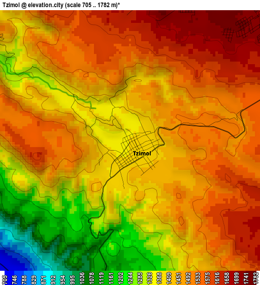
Below is the Elevation map of Tzimol, which displays elevation range with different colors. Scale of the first map is from 705 to 1782 m (2313 to 5846 ft) with average elevation of 1434.3 meters (=4706 ft) [note 1]
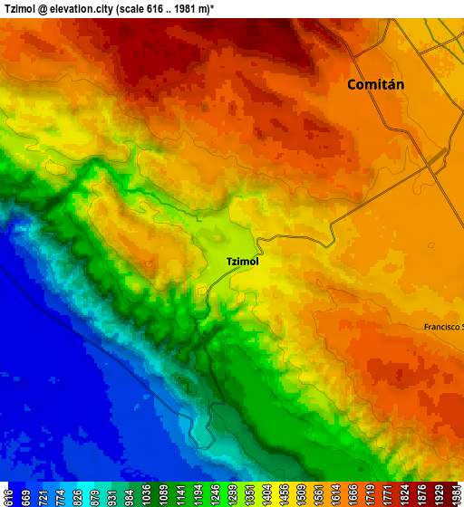
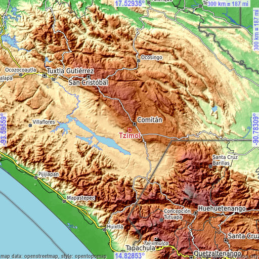
These maps also provides idea of topography and contour of this city, they are displayed at different zoom levels. More info about maps, scale and edge coordinates you can find below images.
| \ | Map #1 | Map #2 | Topo.Map |
| Scale [m] | 705..1782 m | 616..1981 m | × |
| Scale [ft] | 2313..5846 ft | 2021..6499 ft | × |
| Average | 1434.3 m = 4706 ft | 1366.5 m = 4483 ft | × |
| Width | 9.39 km = 5.8 mi | 18.77 km = 11.7 mi | 300.3 km = 186.6 mi |
| Height | 9.39 km = 5.8 mi | 18.77 km = 11.7 mi | 300.3 km = 186.6 mi |
| ↑Max Latitude | 16.225759° | 16.26795° | 17.52935° |
| Latitude at center | 16.18356° | 16.18356° | 16.18356° |
| ↓Min Latitude | 16.141352° | 16.099134° | 14.82853° |
| ← Min Longitude | -92.233285° | -92.277231° | -93.59559° |
| Longitude center | -92.18934° | -92.18934° | -92.18934° |
| →Max Longitude | -92.145395° | -92.101449° | -90.78309° |
Nearby cities:
Cities around Tzimol sort by population:
• Comitán elevation 1632 m
9.1 km,  39°
39°
• La Trinitaria 1564 m
16.3 km,  116°
116°
• San Vicente la Mesilla 627 m
11.1 km,  267°
267°
• San José Yocnajab 1600 m
13.4 km,  54°
54°
• Los Riegos 1589 m
15.1 km,  27°
27°
• Francisco Sarabia 1569 m
9.5 km,  106°
106°
• Cash 1594 m
13.3 km, 47°
• Señor del Pozo 1611 m
15 km, 33°
• Ochusjob 1422 m
8.1 km,  304°
304°
• Tzinil 1161 m
16.4 km, 300°
• Chacaljocóm 1823 m
12.9 km,  2°
2°
• Héroes de Chapultepec 736 m
16.4 km,  219°
219°
Multilingual:
 En español:
Tzimol elevación 1382 m.
 En France:
Tzimol élévation 1382 m.


Sources and notes:
- [note 1] Map square and city borders are not equal. Map elevation data is calculated only from area inside that square.
- [src 1] Elevation data from geonames database provided with same terms of usage.
- [src 2] The elevation map of Tzimol is generated using elevation data from NASA's 3 arcsec (90m) resolution SRTM data.
- [src 3] Base (background) map © OpenStreetMap contributors tiles are generated by Geofabrik and OpenTopoMap.
Copyright & License:
This Tzimol Elevation Map is licensed under CC BY-SA. You may reuse any part from this page, if you give a proper credit by linking to this URL:
 More info on terms of use page.