Paso Hondo elevation
Paso Hondo (Chiapas, Frontera Comalapa), Mexico elevation is 695 meters and Paso Hondo elevation in feet is 2280 ft above sea level [src 1]. Paso Hondo is a populated place (feature code) with elevation that is 619 meters (2031 ft) smaller than average city elevation in Mexico.
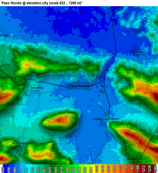
Below is the Elevation map of Paso Hondo, which displays elevation range with different colors. Scale of the first map is from 632 to 1260 m (2073 to 4134 ft) with average elevation of 768.3 meters (=2521 ft) [note 1]
These maps also provides idea of topography and contour of this city, they are displayed at different zoom levels. More info about maps, scale and edge coordinates you can find below images.

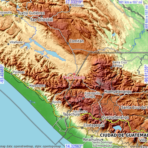
| \ | Map #1 | Map #2 | Topo.Map |
| Scale [m] | 632..1260 m | 611..1948 m | × |
| Scale [ft] | 2073..4134 ft | 2005..6391 ft | × |
| Average | 768.3 m = 2521 ft | 848.8 m = 2785 ft | × |
| Width | 9.41 km = 5.8 mi | 18.82 km = 11.7 mi | 301.1 km = 187.1 mi |
| Height | 9.41 km = 5.8 mi | 18.82 km = 11.7 mi | 301.1 km = 187.1 mi |
| ↑Max Latitude | 15.726205° | 15.768501° | 17.03319° |
| Latitude at center | 15.6839° | 15.6839° | 15.6839° |
| ↓Min Latitude | 15.641586° | 15.599264° | 14.32563° |
| ← Min Longitude | -92.062545° | -92.106491° | -93.42485° |
| Longitude center | -92.0186° | -92.0186° | -92.0186° |
| →Max Longitude | -91.974655° | -91.930709° | -90.61235° |
Nearby cities:
Cities around Paso Hondo sort by population:
• Comalapa elevation 657 m
13.5 km,  258°
258°
• El Pacayal 1031 m
9.8 km,  195°
195°
• Ciudad Cuauhtémoc 707 m
2.5 km,  141°
141°
• Verapaz 702 m
5.6 km,  303°
303°
• Potrerillo 717 m
5.9 km,  182°
182°
• Sabinalito 679 m
4 km,  59°
59°
• Guadalupe Victoria 1213 m
9.8 km,  208°
208°
• Agua Zarca 661 m
14.6 km,  247°
247°
• El Triunfo de las Tres Maravillas 681 m
15.3 km, 254°
• Monte Redondo 773 m
4.9 km,  224°
224°
• Nueva Morelia 664 m
15.4 km,  241°
241°
• El Portal 701 m
8.3 km, 264°
Multilingual:
 En español:
Paso Hondo elevación 695 m.
 En France:
Paso Hondo élévation 695 m.
 Auf Deutsch:
Paso Hondo höhe über dem Meeresspiegel ist 695 m.

Sources and notes:
- [note 1] Map square and city borders are not equal. Map elevation data is calculated only from area inside that square.
- [src 1] Elevation data from geonames database provided with same terms of usage.
- [src 2] The elevation map of Paso Hondo is generated using elevation data from NASA's 3 arcsec (90m) resolution SRTM data.
- [src 3] Base (background) map © OpenStreetMap contributors tiles are generated by Geofabrik and OpenTopoMap.
Copyright & License:
This Paso Hondo Elevation Map is licensed under CC BY-SA. You may reuse any part from this page, if you give a proper credit by linking to this URL:
 More info on terms of use page.