Laguna de Farfán elevation
Laguna de Farfán (Veracruz, Juchique de Ferrer), Mexico elevation is 667 meters and Laguna de Farfán elevation in feet is 2188 ft above sea level [src 1]. Laguna de Farfán is a populated place (feature code) with elevation that is 647 meters (2123 ft) smaller than average city elevation in Mexico.
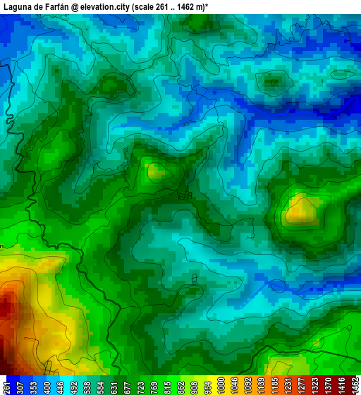
Below is the Elevation map of Laguna de Farfán, which displays elevation range with different colors. Scale of the first map is from 261 to 1462 m (856 to 4797 ft) with average elevation of 608.6 meters (=1997 ft) [note 1]
These maps also provides idea of topography and contour of this city, they are displayed at different zoom levels. More info about maps, scale and edge coordinates you can find below images.
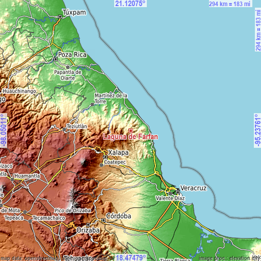
| \ | Map #1 | Topo.Map |
| Scale [m] | 261..1462 m | × |
| Scale [ft] | 856..4797 ft | × |
| Average | 608.6 m = 1997 ft | × |
| Width | 9.19 km = 5.7 mi | 294.2 km = 182.8 mi |
| Height | 9.19 km = 5.7 mi | 294.2 km = 182.8 mi |
| ↑Max Latitude | 19.844611° | 21.12075° |
| Latitude at center | 19.80327° | 19.80327° |
| ↓Min Latitude | 19.761918° | 18.47479° |
| ← Min Longitude | -96.687805° | -98.05011° |
| Longitude center | -96.64386° | -96.64386° |
| →Max Longitude | -96.599915° | -95.23761° |
Nearby cities:
Cities around Laguna de Farfán sort by population:
• Villa Emilio Carranza elevation 65 m
18.9 km,  10°
10°
• Alto Lucero 1119 m
22 km,  205°
205°
• Chiconquiaco 2066 m
19.5 km,  249°
249°
• Yecuatla 468 m
15.7 km,  296°
296°
• Juchique de Ferrer 385 m
6.7 km,  307°
307°
• Colipa 193 m
15.9 km,  326°
326°
• Plan de las Hayas 1057 m
5.9 km, 214°
• Tepetlán 1197 m
21.6 km,  227°
227°
• El Huérfano 1603 m
12.7 km,  236°
236°
• Mafafas 1335 m
19.9 km,  216°
216°
• Monte Verde Chivería 1468 m
12.4 km, 206°
• La Sombra 1221 m
9.4 km, 231°
Multilingual:
 En español:
Laguna de Farfán elevación 667 m.
 En France:
Laguna de Farfán élévation 667 m.
 Auf Deutsch:
Laguna de Farfán höhe über dem Meeresspiegel ist 667 m.

Sources and notes:
- [note 1] Map square and city borders are not equal. Map elevation data is calculated only from area inside that square.
- [src 1] Elevation data from geonames database provided with same terms of usage.
- [src 2] The elevation map of Laguna de Farfán is generated using elevation data from NASA's 3 arcsec (90m) resolution SRTM data.
- [src 3] Base (background) map © OpenStreetMap contributors tiles are generated by Geofabrik and OpenTopoMap.
Copyright & License:
This Laguna de Farfán Elevation Map is licensed under CC BY-SA. You may reuse any part from this page, if you give a proper credit by linking to this URL:
 More info on terms of use page.