Alto Lucero elevation
Alto Lucero (Veracruz, Alto Lucero de Gutiérrez Barrios), Mexico elevation is 1119 meters and Alto Lucero elevation in feet is 3671 ft above sea level [src 1]. Alto Lucero is a seat of a second-order administrative division (feature code) with elevation that is 195 meters (640 ft) smaller than average city elevation in Mexico.
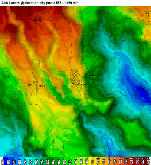
Below is the Elevation map of Alto Lucero, which displays elevation range with different colors. Scale of the first map is from 553 to 1460 m (1814 to 4790 ft) with average elevation of 971.7 meters (=3188 ft) [note 1]
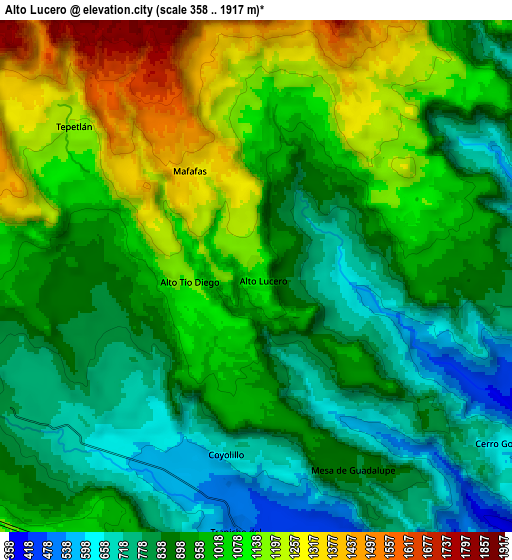
These maps also provides idea of topography and contour of this city, they are displayed at different zoom levels. More info about maps, scale and edge coordinates you can find below images.
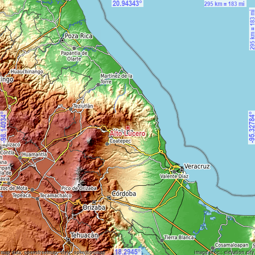
| \ | Map #1 | Map #2 | Topo.Map |
| Scale [m] | 553..1460 m | 358..1917 m | × |
| Scale [ft] | 1814..4790 ft | 1175..6289 ft | × |
| Average | 971.7 m = 3188 ft | 963.2 m = 3160 ft | × |
| Width | 9.2 km = 5.7 mi | 18.41 km = 11.4 mi | 294.5 km = 183 mi |
| Height | 9.2 km = 5.7 mi | 18.41 km = 11.4 mi | 294.6 km = 183.1 mi |
| ↑Max Latitude | 19.665807° | 19.707184° | 20.94343° |
| Latitude at center | 19.62442° | 19.62442° | 19.62442° |
| ↓Min Latitude | 19.583022° | 19.541613° | 18.2945° |
| ← Min Longitude | -96.778035° | -96.821981° | -98.14034° |
| Longitude center | -96.73409° | -96.73409° | -96.73409° |
| →Max Longitude | -96.690145° | -96.646199° | -95.32784° |
Nearby cities:
Cities around Alto Lucero sort by population:
• Mesa de Guadalupe elevation 834 m
7.6 km,  151°
151°
• Tepetlán 1197 m
8.6 km,  309°
309°
• Blanca Espuma 686 m
6.8 km,  135°
135°
• El Huérfano 1603 m
13 km,  354°
354°
• Chicuasen 350 m
12.5 km, 148°
• Mafafas 1335 m
4.4 km,  329°
329°
• La Reforma 684 m
11 km,  106°
106°
• Trapiche del Rosario 481 m
9.1 km,  184°
184°
• Cerro Gordo 644 m
10.9 km,  124°
124°
• El Terrero 1065 m
11.9 km,  215°
215°
• Otates 528 m
11.7 km,  170°
170°
• Monte Verde Chivería 1468 m
9.6 km,  24°
24°
Multilingual:
 En español:
Alto Lucero elevación 1119 m.
 En France:
Alto Lucero élévation 1119 m.
 Auf Deutsch:
Alto Lucero höhe über dem Meeresspiegel ist 1119 m.

Sources and notes:
- [note 1] Map square and city borders are not equal. Map elevation data is calculated only from area inside that square.
- [src 1] Elevation data from geonames database provided with same terms of usage.
- [src 2] The elevation map of Alto Lucero is generated using elevation data from NASA's 3 arcsec (90m) resolution SRTM data.
- [src 3] Base (background) map © OpenStreetMap contributors tiles are generated by Geofabrik and OpenTopoMap.
Copyright & License:
This Alto Lucero Elevation Map is licensed under CC BY-SA. You may reuse any part from this page, if you give a proper credit by linking to this URL:
 More info on terms of use page.