Mafafas elevation
Mafafas (Veracruz, Tepetlán), Mexico elevation is 1335 meters and Mafafas elevation in feet is 4380 ft above sea level [src 1]. Mafafas is a populated place (feature code) with elevation that is 21 meters (69 ft) bigger than average city elevation in Mexico.
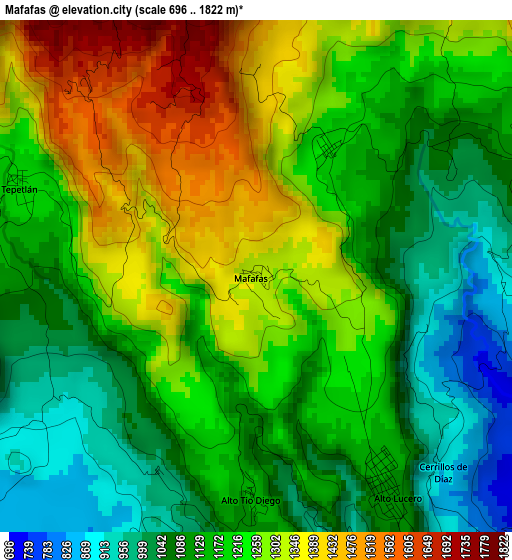
Below is the Elevation map of Mafafas, which displays elevation range with different colors. Scale of the first map is from 696 to 1822 m (2283 to 5978 ft) with average elevation of 1194.5 meters (=3919 ft) [note 1]
These maps also provides idea of topography and contour of this city, they are displayed at different zoom levels. More info about maps, scale and edge coordinates you can find below images.
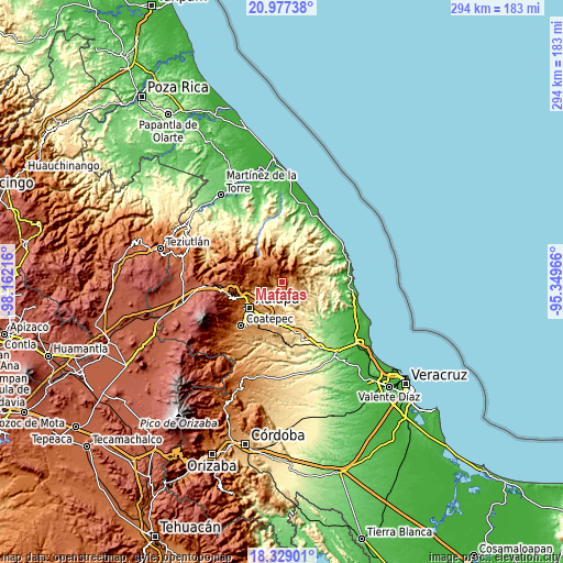
| \ | Map #1 | Topo.Map |
| Scale [m] | 696..1822 m | × |
| Scale [ft] | 2283..5978 ft | × |
| Average | 1194.5 m = 3919 ft | × |
| Width | 9.2 km = 5.7 mi | 294.5 km = 183 mi |
| Height | 9.2 km = 5.7 mi | 294.5 km = 183 mi |
| ↑Max Latitude | 19.700039° | 20.97738° |
| Latitude at center | 19.65866° | 19.65866° |
| ↓Min Latitude | 19.617271° | 18.32901° |
| ← Min Longitude | -96.799855° | -98.16216° |
| Longitude center | -96.75591° | -96.75591° |
| →Max Longitude | -96.711965° | -95.34966° |
Nearby cities:
Cities around Mafafas sort by population:
• Naolinco de Victoria elevation 1555 m
12.3 km,  267°
267°
• Alto Lucero 1119 m
4.4 km,  149°
149°
• Chiconquiaco 2066 m
11.4 km,  324°
324°
• Mesa de Guadalupe 834 m
12.1 km, 150°
• Acatlán 1749 m
10 km,  295°
295°
• Tepetlán 1197 m
4.6 km,  290°
290°
• El Espinal 986 m
12.8 km,  252°
252°
• Blanca Espuma 686 m
11.2 km,  140°
140°
• El Huérfano 1603 m
9.2 km,  6°
6°
• Trapiche del Rosario 481 m
12.9 km,  173°
173°
• Monte Verde Chivería 1468 m
8 km,  51°
51°
• La Sombra 1221 m
11.1 km,  23°
23°
Multilingual:
 En español:
Mafafas elevación 1335 m.
 En France:
Mafafas élévation 1335 m.
 Auf Deutsch:
Mafafas höhe über dem Meeresspiegel ist 1335 m.

Sources and notes:
- [note 1] Map square and city borders are not equal. Map elevation data is calculated only from area inside that square.
- [src 1] Elevation data from geonames database provided with same terms of usage.
- [src 2] The elevation map of Mafafas is generated using elevation data from NASA's 3 arcsec (90m) resolution SRTM data.
- [src 3] Base (background) map © OpenStreetMap contributors tiles are generated by Geofabrik and OpenTopoMap.
Copyright & License:
This Mafafas Elevation Map is licensed under CC BY-SA. You may reuse any part from this page, if you give a proper credit by linking to this URL:
 More info on terms of use page.