La Isla elevation
La Isla (Veracruz, Tierra Blanca), Mexico elevation is 23 meters and La Isla elevation in feet is 75 ft above sea level [src 1]. La Isla is a populated place (feature code) with elevation that is 1291 meters (4236 ft) smaller than average city elevation in Mexico.
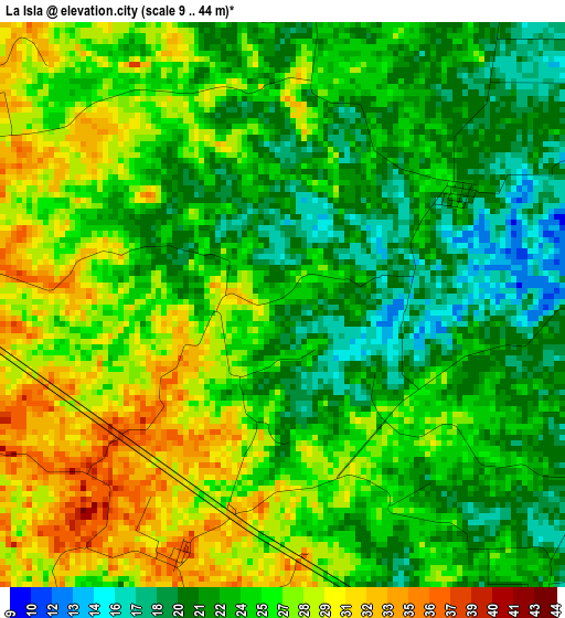
Below is the Elevation map of La Isla, which displays elevation range with different colors. Scale of the first map is from 9 to 44 m (30 to 144 ft) with average elevation of 24.8 meters (=81 ft) [note 1]
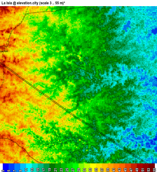
These maps also provides idea of topography and contour of this city, they are displayed at different zoom levels. More info about maps, scale and edge coordinates you can find below images.
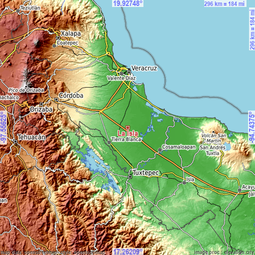
| \ | Map #1 | Map #2 | Topo.Map |
| Scale [m] | 9..44 m | 3..55 m | × |
| Scale [ft] | 30..144 ft | 10..180 ft | × |
| Average | 24.8 m = 81 ft | 24.6 m = 81 ft | × |
| Width | 9.26 km = 5.8 mi | 18.52 km = 11.5 mi | 296.4 km = 184.2 mi |
| Height | 9.26 km = 5.8 mi | 18.52 km = 11.5 mi | 296.4 km = 184.2 mi |
| ↑Max Latitude | 18.641645° | 18.68328° | 19.92748° |
| Latitude at center | 18.6° | 18.6° | 18.6° |
| ↓Min Latitude | 18.558345° | 18.51668° | 17.26209° |
| ← Min Longitude | -96.193945° | -96.237891° | -97.55625° |
| Longitude center | -96.15° | -96.15° | -96.15° |
| →Max Longitude | -96.106055° | -96.062109° | -94.74375° |
Nearby cities:
Cities around La Isla sort by population:
• Tierra Blanca elevation 67 m
27.8 km,  232°
232°
• Piedras Negras 33 m
19.1 km,  353°
353°
• Ignacio de la Llave 12 m
22.2 km,  50°
50°
• Los Naranjos 32 m
27.3 km,  183°
183°
• Tlalixcoyan 11 m
24.4 km,  22°
22°
• Tetela 92 m
34.1 km,  252°
252°
• Joachín 47 m
9.8 km,  296°
296°
• Poblado Dos 20 m
33.3 km,  159°
159°
• El Cocuite 20 m
14.8 km,  27°
27°
• Rodríguez Tejeda 107 m
28.2 km,  277°
277°
• Nuevo San José Independencia 22 m
25.2 km, 158°
• Zacate Colorado Segundo (Fraternidad) 7 m
21 km,  63°
63°
Multilingual:
 En español:
La Isla elevación 23 m.
 En France:
La Isla élévation 23 m.


Sources and notes:
- [note 1] Map square and city borders are not equal. Map elevation data is calculated only from area inside that square.
- [src 1] Elevation data from geonames database provided with same terms of usage.
- [src 2] The elevation map of La Isla is generated using elevation data from NASA's 3 arcsec (90m) resolution SRTM data.
- [src 3] Base (background) map © OpenStreetMap contributors tiles are generated by Geofabrik and OpenTopoMap.
Copyright & License:
This La Isla Elevation Map is licensed under CC BY-SA. You may reuse any part from this page, if you give a proper credit by linking to this URL:
 More info on terms of use page.