Tlalixcoyan elevation
Tlalixcoyan (Veracruz), Mexico elevation is 11 meters and Tlalixcoyan elevation in feet is 36 ft above sea level [src 1]. Tlalixcoyan is a populated place (feature code) with elevation that is 1303 meters (4275 ft) smaller than average city elevation in Mexico.
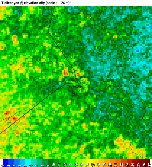
Below is the Elevation map of Tlalixcoyan, which displays elevation range with different colors. Scale of the first map is from 1 to 24 m (3 to 79 ft) with average elevation of 10.9 meters (=36 ft) [note 1]
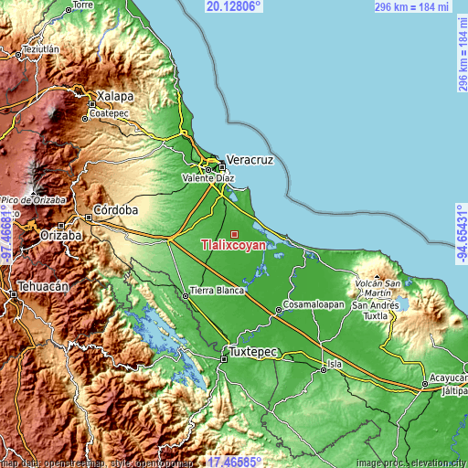
These maps also provides idea of topography and contour of this city, they are displayed at different zoom levels. More info about maps, scale and edge coordinates you can find below images.
| \ | Map #1 | Topo.Map |
| Scale [m] | 1..24 m | × |
| Scale [ft] | 3..79 ft | × |
| Average | 10.9 m = 36 ft | × |
| Width | 9.25 km = 5.7 mi | 296 km = 183.9 mi |
| Height | 9.25 km = 5.7 mi | 296 km = 183.9 mi |
| ↑Max Latitude | 18.843815° | 20.12806° |
| Latitude at center | 18.80222° | 18.80222° |
| ↓Min Latitude | 18.760615° | 17.46585° |
| ← Min Longitude | -96.104505° | -97.46681° |
| Longitude center | -96.06056° | -96.06056° |
| →Max Longitude | -96.016615° | -94.65431° |
Nearby cities:
Cities around Tlalixcoyan sort by population:
• La Isla elevation 23 m
24.4 km,  202°
202°
• Piedras Negras 33 m
12.2 km,  253°
253°
• Ignacio de la Llave 12 m
11.5 km,  137°
137°
• Los Robles 30 m
19.9 km,  342°
342°
• Joachín 47 m
25.7 km,  224°
224°
• La Laguna y Monte del Castillo 14 m
20.2 km,  354°
354°
• El Cocuite 20 m
9.7 km,  194°
194°
• La Capilla 30 m
21.6 km,  298°
298°
• Ejidal 24 m
20.7 km, 303°
• Zacate Colorado Segundo (Fraternidad) 7 m
16.2 km, 144°
• Arbolillo 8 m
23.7 km,  86°
86°
• Salinas 10 m
15.8 km,  51°
51°
Multilingual:
 En español:
Tlalixcoyan elevación 11 m.
 En France:
Tlalixcoyan élévation 11 m.
 Auf Deutsch:
Tlalixcoyan höhe über dem Meeresspiegel ist 11 m.

Sources and notes:
- [note 1] Map square and city borders are not equal. Map elevation data is calculated only from area inside that square.
- [src 1] Elevation data from geonames database provided with same terms of usage.
- [src 2] The elevation map of Tlalixcoyan is generated using elevation data from NASA's 3 arcsec (90m) resolution SRTM data.
- [src 3] Base (background) map © OpenStreetMap contributors tiles are generated by Geofabrik and OpenTopoMap.
Copyright & License:
This Tlalixcoyan Elevation Map is licensed under CC BY-SA. You may reuse any part from this page, if you give a proper credit by linking to this URL:
 More info on terms of use page.