Malinaltepec elevation
Malinaltepec (Guerrero), Mexico elevation is 1522 meters and Malinaltepec elevation in feet is 4993 ft above sea level [src 1]. Malinaltepec is a seat of a second-order administrative division (feature code) with elevation that is 208 meters (682 ft) bigger than average city elevation in Mexico.
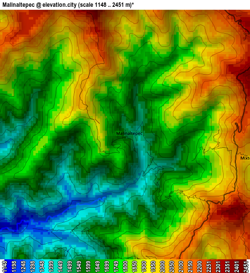
Below is the Elevation map of Malinaltepec, which displays elevation range with different colors. Scale of the first map is from 1148 to 2451 m (3766 to 8041 ft) with average elevation of 1783.7 meters (=5852 ft) [note 1]
These maps also provides idea of topography and contour of this city, they are displayed at different zoom levels. More info about maps, scale and edge coordinates you can find below images.
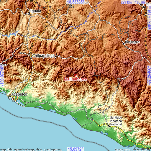
| \ | Map #1 | Topo.Map |
| Scale [m] | 1148..2451 m | × |
| Scale [ft] | 3766..8041 ft | × |
| Average | 1783.7 m = 5852 ft | × |
| Width | 9.33 km = 5.8 mi | 298.6 km = 185.5 mi |
| Height | 9.33 km = 5.8 mi | 298.7 km = 185.6 mi |
| ↑Max Latitude | 17.286975° | 18.58305° |
| Latitude at center | 17.24501° | 17.24501° |
| ↓Min Latitude | 17.203035° | 15.8972° |
| ← Min Longitude | -98.714855° | -100.07716° |
| Longitude center | -98.67091° | -98.67091° |
| →Max Longitude | -98.626965° | -97.26466° |
Nearby cities:
Cities around Malinaltepec sort by population:
• Tototepec elevation 1677 m
22.6 km,  23°
23°
• Cuatzoquitengo 2038 m
7.6 km,  50°
50°
• Iliatenco 1050 m
22.2 km,  184°
184°
• Tlacoapa 1411 m
8.5 km,  284°
284°
• Santa Anita 1571 m
20.7 km,  345°
345°
• Patlicha 1423 m
22.3 km, 346°
• Colombia de Guadalupe 1385 m
19.8 km,  208°
208°
• Paraje Montero (Paraje Montero de Zaragoza) 1988 m
9.7 km,  201°
201°
• Zilacayotitlán 2255 m
14 km,  66°
66°
• El Tejocote 2489 m
9.4 km,  7°
7°
• Totomixtlahuaca 858 m
17 km,  235°
235°
• Moyotepec (Moyotepec de Juárez) 2264 m
9.8 km, 350°
Multilingual:
 En español:
Malinaltepec elevación 1522 m.
 En France:
Malinaltepec élévation 1522 m.
 Auf Deutsch:
Malinaltepec höhe über dem Meeresspiegel ist 1522 m.

Sources and notes:
- [note 1] Map square and city borders are not equal. Map elevation data is calculated only from area inside that square.
- [src 1] Elevation data from geonames database provided with same terms of usage.
- [src 2] The elevation map of Malinaltepec is generated using elevation data from NASA's 3 arcsec (90m) resolution SRTM data.
- [src 3] Base (background) map © OpenStreetMap contributors tiles are generated by Geofabrik and OpenTopoMap.
Copyright & License:
This Malinaltepec Elevation Map is licensed under CC BY-SA. You may reuse any part from this page, if you give a proper credit by linking to this URL:
 More info on terms of use page.