Cuatzoquitengo elevation
Cuatzoquitengo (Guerrero, Malinaltepec), Mexico elevation is 2038 meters and Cuatzoquitengo elevation in feet is 6686 ft above sea level [src 1]. Cuatzoquitengo is a populated place (feature code) with elevation that is 724 meters (2375 ft) bigger than average city elevation in Mexico.
Below is the Elevation map of Cuatzoquitengo, which displays elevation range with different colors. Scale of the first map is from 1591 to 2885 m (5220 to 9465 ft) with average elevation of 2130.3 meters (=6989 ft) [note 1]
These maps also provides idea of topography and contour of this city, they are displayed at different zoom levels. More info about maps, scale and edge coordinates you can find below images.
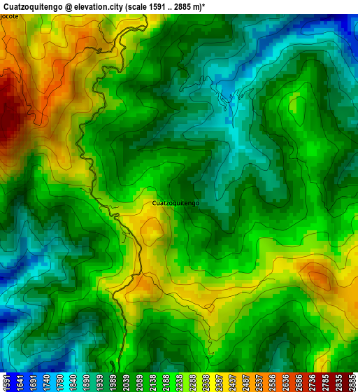
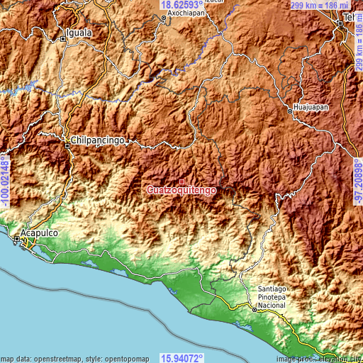
| \ | Map #1 | Topo.Map |
| Scale [m] | 1591..2885 m | × |
| Scale [ft] | 5220..9465 ft | × |
| Average | 2130.3 m = 6989 ft | × |
| Width | 9.33 km = 5.8 mi | 298.6 km = 185.5 mi |
| Height | 9.33 km = 5.8 mi | 298.6 km = 185.5 mi |
| ↑Max Latitude | 17.330175° | 18.62593° |
| Latitude at center | 17.28822° | 17.28822° |
| ↓Min Latitude | 17.246255° | 15.94072° |
| ← Min Longitude | -98.659175° | -100.02148° |
| Longitude center | -98.61523° | -98.61523° |
| →Max Longitude | -98.571285° | -97.20898° |
Nearby cities:
Cities around Cuatzoquitengo sort by population:
• Tototepec elevation 1677 m
16.3 km,  10°
10°
• Cochoapa el Grande 2017 m
20 km,  122°
122°
• Tlacoapa 1411 m
14.4 km,  259°
259°
• Cahuatache 1556 m
16.8 km,  31°
31°
• Santa Anita 1571 m
18.8 km,  324°
324°
• Malinaltepec 1522 m
7.6 km,  230°
230°
• Paraje Montero (Paraje Montero de Zaragoza) 1988 m
16.8 km,  214°
214°
• Ocotequila 1706 m
19.1 km,  339°
339°
• Zilacayotitlán 2255 m
7 km,  83°
83°
• El Tejocote 2489 m
6.5 km,  314°
314°
• Melchor Ocampo 1535 m
19.5 km,  66°
66°
• Moyotepec (Moyotepec de Juárez) 2264 m
8.9 km,  302°
302°
Multilingual:
 En español:
Cuatzoquitengo elevación 2038 m.
 En France:
Cuatzoquitengo élévation 2038 m.
 Auf Deutsch:
Cuatzoquitengo höhe über dem Meeresspiegel ist 2038 m.

Sources and notes:
- [note 1] Map square and city borders are not equal. Map elevation data is calculated only from area inside that square.
- [src 1] Elevation data from geonames database provided with same terms of usage.
- [src 2] The elevation map of Cuatzoquitengo is generated using elevation data from NASA's 3 arcsec (90m) resolution SRTM data.
- [src 3] Base (background) map © OpenStreetMap contributors tiles are generated by Geofabrik and OpenTopoMap.
Copyright & License:
This Cuatzoquitengo Elevation Map is licensed under CC BY-SA. You may reuse any part from this page, if you give a proper credit by linking to this URL:
 More info on terms of use page.